Towns & cities · South Wales
Argoed
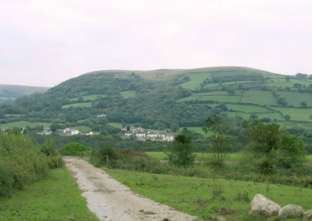
Argoed — village and community in Caerphilly County Borough, Wales.

Wikimedia Commons contributors — see linked file page for photographer and licence licence
Plan your visit
- Typical visit
- 3 h–6 h
- Nearest railway station
- Gilfach Fargoed · 2.6 km
- Free entry
- Family-friendly
- Dog-friendly
About
Argoed is a town, city, village or settlement in the United Kingdom. It covers approximately 1,567 km². Recent population estimates put it at around 2,515 people. Wikidata describes it as: "village and community in Caerphilly County Borough, Wales". Coordinates: 51.6903°, -3.1914°.
Photo gallery
Heritage listing
http://cadwpublic-api.azurewebsites.net/reports/listedbuilding/FullReport?lang=en&id=82646
From Cadw under OGL v3.
From the Wikipedia article
Argoed (Welsh for 'by a wood' / 'by a grove') is a village, community and an electoral ward in the Sirhowy Valley between Blackwood and Tredegar in Caerphilly County Borough in south Wales. The population of the community and ward at the 2011 census was 2,769. As a community, Argoed also contains the villages of Markham and Hollybush. Before 1960 the village was served by Argoed railway station. This was initially a stop on the Sirhowy Tramroad, which opened in 1822. The tramroad was converted to a conventional standard gauge railway in 1865, the Sirhowy Railway. The station closed in 1960 and the railway has been converted into a cycle path. Zephaniah Williams, prosecuted for his part in the Chartist Newport Rising in 1839, was born in the village in 1795.
Excerpt from Wikipedia under CC BY-SA 4.0. See the source article linked in Sources below.
- Coordinates
- 51.6903, -3.1914
- District
- Caerphilly
- Parish
- Argoed
- Postcode
- NP12 0AL
- Parliamentary constituency
- Newport West and Islwyn
- Population
- 2,515
- Nearest railway station
- Gilfach Fargoed — 2.6 km
Sources
- wikidata: Q378738 (CC0)
- wikipedia: Argoed, Caerphilly (CC BY-SA 4.0)
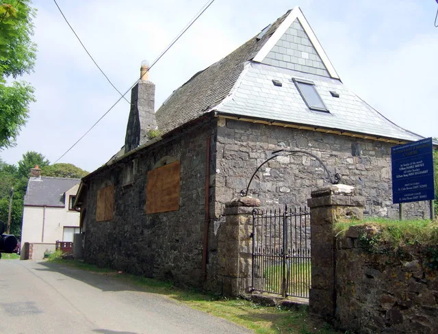
- commons: Argoed Baptist Chapel - geograph.org.uk - 1992369.jpg (CC BY-SA 4.0)
Other places nearby
Loading nearby places…
Nearby
 📷 5
📷 5Historic churches · South Wales
St Sannan's Church
St Sannan's Church — Grade II* listed building-listed church in wales-south, United Kingdom.
 📷 5
📷 5Historic bridges · South Wales
Pont Syr Dafydd
Pont Syr Dafydd — Grade II listed building-listed bridge in wales-south, United Kingdom.
 📷 3
📷 3Forests & woodlands · South Wales
Aberbargoed Grasslands National Nature Reserve
Aberbargoed Grasslands National Nature Reserve is a forest or woodland in the United Kingdom.
 📷 3
📷 3Theatres · South Wales
Oakdale Picture House
Oakdale Picture House in Wales South, United Kingdom.
Caravan parks · South Wales
Pen y fan Caravan and Leisure Park
Pen y fan Caravan and Leisure Park — a caravan park in wales south.
 📷 3
📷 3Memorials & monuments · South Wales
Markham War Memorial
Markham War Memorial — a memorial in wales-south, United Kingdom.
More towns in this region
 Flagship📷 3
Towns & cities · South Wales
Betws
Betws — village and community in Carmarthenshire, Wales.
 Flagship📷 5
Towns & cities · South Wales
Caerleon
Caerleon — village and community in Newport, Wales, UK.
 Flagship📷 3
Towns & cities · South Wales
Camrose
Camrose — village and community in Pembrokeshire, Wales, UK.
 Flagship📷 4
Towns & cities · South Wales
Cardiff
Cardiff — capital city of Wales, United Kingdom.
Frequently asked questions
- Where is Argoed?
- Argoed is in South Wales, United Kingdom (postcode NP12 0AL), in the parish of Argoed.
- Is Argoed a listed building?
- Argoed is officially recognised as II listed.
- Is Argoed free to visit?
- Yes, Argoed is free to enter.
- How do I get to Argoed?
- The nearest railway station is Gilfach Fargoed, about 2.6 km away. Drivers can navigate to postcode NP12 0AL.