Towns & cities · Mid Wales
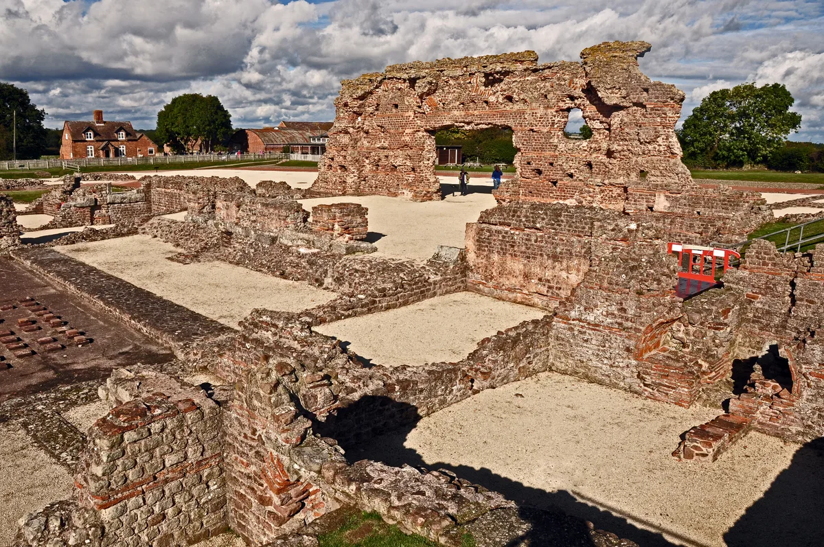
Wroxeter
Also known as: Caerwrygion
Wroxeter — village in Shropshire, England, UK.

Wikimedia Commons contributors — see linked file page for photographer and licence licence
Plan your visit
- Typical visit
- 3 h–6 h
- Nearest railway station
- Shrewsbury · 8.3 km
- Free entry
- Family-friendly
- Dog-friendly
About
Wroxeter is a town, city, village or settlement in the United Kingdom. Address: SY5. Wikidata describes it as: "village in Shropshire, England, UK". Coordinates: 52.6706°, -2.6475°.
Photo gallery
Protected designations
- Area of Outstanding Natural Beauty: Shropshire Hills
Designations sourced from Natural England open data under OGL v3.
From the Wikipedia article
Wroxeter ( ROK-sit-ər) is a village and former civil parish, now in the parish of Wroxeter and Uppington, in the Shropshire district, in the ceremonial county of Shropshire, England. It is beside the River Severn, 5 miles (8.0 km) east-south-east of Shrewsbury. In 1961 the parish had a population of 657. Viroconium Cornoviorum, the fourth largest city in Roman Britain, was sited here, and is gradually being excavated. In 2024, archaeologists uncovered a 2,000-year-old mosaic depicting dolphins and fish. The village contains one of Shropshire's commercial vineyards.
Excerpt from Wikipedia under CC BY-SA 4.0. See the source article linked in Sources below.
Background
History
Roman Wroxeter, near the end of the Watling Street Roman road that ran across Romanised Celtic Britain from Dubris (Dover), was a key frontier position lying on the bank of the River Severn whose valley penetrated deep into what later became known as Wales, and also on a route south leading to the Wye valley. Archaeology has shown that the site of the later city first was established about AD 55 as a frontier post for a Thracian legionary cohort located at a fort near the Severn river crossing. A few years later a legionary fortress (castrum) was built within the site of the later city for the Legio XIV Gemina during their invasion of Wales. The local British tribe of the Cornovii had their…
Sourced from Wikipedia under CC BY-SA 4.0.
- Coordinates
- 52.6706, -2.6475
- District
- Shropshire
- Parish
- Wroxeter and Uppington
- Postcode
- SY5
- Parliamentary constituency
- South Shropshire
- Nearest railway station
- Shrewsbury — 8.3 km
- Official site
- www.2shrop.net
Sources
- wikidata: Q1848222 (CC0)
- wikipedia: Wroxeter (CC BY-SA 4.0)
- commons: WroxeterRomanCity.jpg (CC BY-SA 4.0)
Other places nearby
Loading nearby places…
Nearby
 📷 4
📷 4Historic churches · Mid Wales
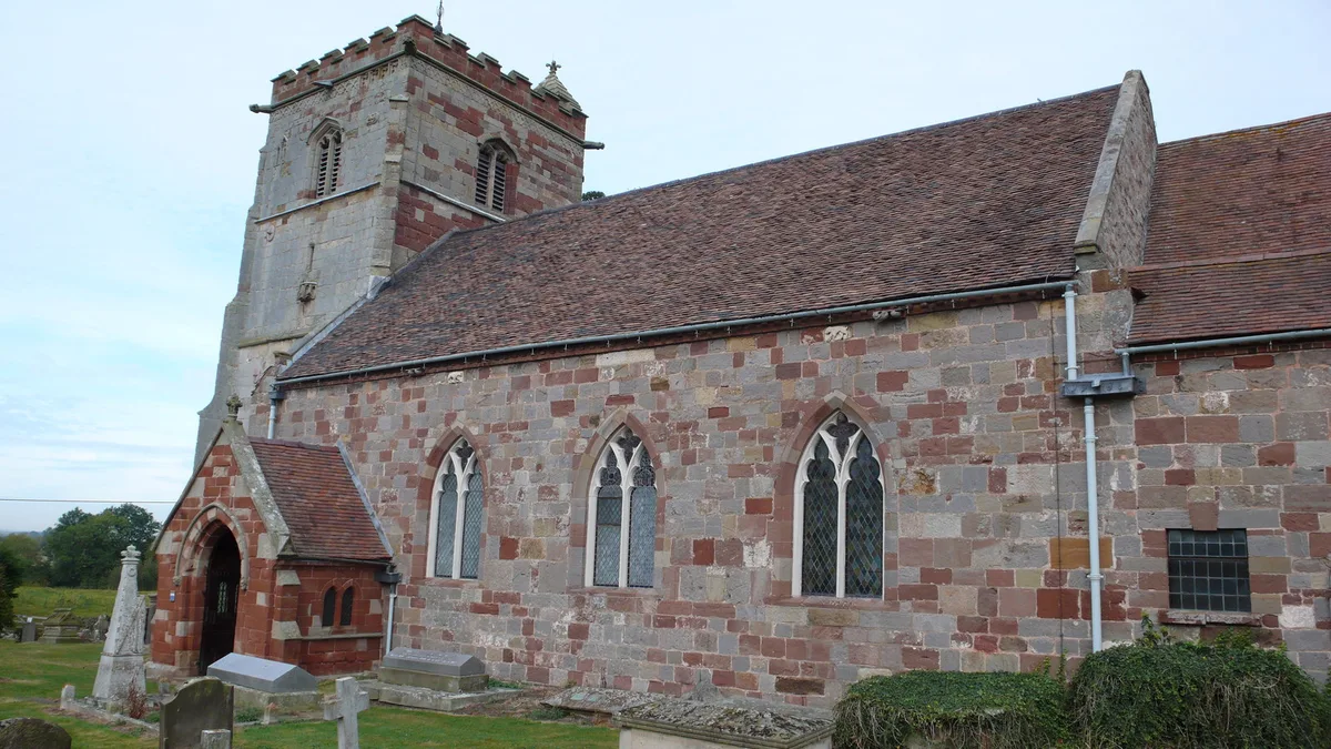
St Andrew's Church, Wroxeter
St Andrew's Church, Wroxeter — church in Wroxeter, Shropshire, England, UK.
 📷 3
📷 3Museums · Mid Wales
Wroxeter Roman Site Museum
Wroxeter Roman Site Museum — a museum in wales-mid, United Kingdom.
 📷 3
📷 3Archaeological sites · Mid Wales
Wroxeter Roman City/Viroconium
Wroxeter Roman City/Viroconium — a archaeological in wales-mid, United Kingdom.
 📷 3
📷 3Museums · Mid Wales
Wroxeter Roman City Museum
Wroxeter Roman City Museum — a museum in wales-mid, United Kingdom.
 📷 5
📷 5Follies · Mid Wales
Roman temple at insula I, Wroxeter
Roman temple at insula I, Wroxeter — a temple folly in wales-mid, United Kingdom.
 📷 3
📷 3Hill forts · Mid Wales
Viroconium Cornoviorum
Viroconium Cornoviorum — Roman town, near Wroxeter in modern-day Shropshire, England.
More towns in this region
 📷 4
📷 4Towns & cities · Mid Wales
Aberdyfi
Aberdyfi — village and community in Gwynedd, Wales.
 Flagship📷 3
Towns & cities · Mid Wales
Aberporth
Aberporth — village and community in Ceredigion, Wales, UK.
 📷 4
📷 4Towns & cities · Mid Wales
Borth
Borth — village and community in Ceredigion, Wales, UK.
 Flagship📷 5
Towns & cities · Mid Wales
Caersws
Caersws — village and community in Powys, Wales.
Frequently asked questions
- Where is Wroxeter?
- Wroxeter is in Mid Wales, United Kingdom (postcode SY5), in the parish of Wroxeter and Uppington.
- Is Wroxeter a protected site?
- Yes — Wroxeter is part of the Shropshire Hills National Landscape (AONB).
- Is Wroxeter free to visit?
- Yes, Wroxeter is free to enter.
- How do I get to Wroxeter?
- Drivers can navigate to postcode SY5. It sits within the South Shropshire parliamentary constituency.