Towns & cities · East of England
Wordwell
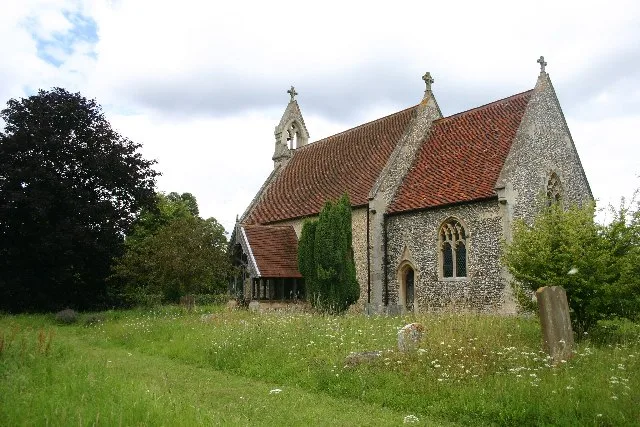
Wordwell — village in Suffolk, England, UK.

Philip Halling — CC BY-SA 2.0 via Wikimedia Commons licence
Plan your visit
- Typical visit
- 3 h–6 h
- Nearest railway station
- Bury St Edmunds · 7.3 km
- Free entry
- Family-friendly
- Dog-friendly
About
Wordwell is a town, city, village or settlement in the United Kingdom. Recent population estimates put it at around 21 people. Wikidata describes it as: "village in Suffolk, England, UK". Coordinates: 52.3170°, 0.6830°.
Photo gallery
Protected designations
- Site of Special Scientific Interest: Breckland Forest SSSI
- Site of Special Scientific Interest: Breckland Farmland SSSI
Designations sourced from Natural England open data under OGL v3.
From the Wikipedia article
Wordwell is a small village and civil parish in the West Suffolk district of Suffolk, England, about five miles north of Bury St Edmunds. The village was hit by the Black Death in 1348 and never recovered in terms of population; in 2005 it was estimated to have only 20 residents. During the 19th and early 20th centuries it was part of the Culford Estate. From 1974 to 2019 it was in St Edmundsbury district. The village is mentioned as Wridewellan in the S1225 charter of 1040 AD where Thurketel grants the lands to Bury Abbey. All Saints Church is largely Norman but with Victorian alterations. Wordwell is also one of very few Thankful Villages, that is to say one which lost no men during either world war, but it is unclear whether any men left the village to serve in the first place. The church has carvings on benches and in stone. A mass grave, probably from the time of the Black Death, was found when electricity was provided to the church. Google Earth shows the outlines of buildings that once stood on the other side of the road.
Excerpt from Wikipedia under CC BY-SA 4.0. See the source article linked in Sources below.
- Coordinates
- 52.3170, 0.6830
- County
- Suffolk
- District
- West Suffolk
- Parish
- Wordwell
- Postcode
- IP28 6UN
- Parliamentary constituency
- West Suffolk
- Population
- 21
- Nearest railway station
- Bury St Edmunds — 7.3 km
Sources
Other places nearby
Loading nearby places…
Nearby
 📷 3
📷 3Historic churches · East of England
All Saints Church, Wordwell
All Saints Church, Wordwell — church in Wordwell, UK.
Campsites · East of England
West Stow Pods
West Stow Pods — a campsite in england east.
 📷 3
📷 3Public art & sculpture · East of England
West Stow Village Sign
West Stow Village Sign — a public art in england-east, United Kingdom.
 📷 5
📷 5Historic bridges · East of England
The Iron Bridge At Culford School
The Iron Bridge At Culford School — a Grade I-listed bridge in england-east, United Kingdom.
 📷 3
📷 3Manor houses · East of England
Culford Hall
Culford Hall — a manor in england-east, United Kingdom.
 📷 3
📷 3Public art & sculpture · East of England
Culford Village Sign
Culford Village Sign — a public art in england-east, United Kingdom.
More towns in this region
 Flagship📷 3
Towns & cities · East of England
Alburgh
Alburgh — village and civil parish in Norfolk, UK.
 Flagship📷 3
Towns & cities · East of England
Aldeby
Aldeby — village and civil parish in Norfolk, UK.
 Flagship📷 5
Towns & cities · East of England
Ashill
Ashill — village and civil parish in the English county of Norfolk.
 Flagship📷 3
Towns & cities · East of England
Aslacton
Aslacton — village and civil parish in Norfolk, UK.
Frequently asked questions
- Where is Wordwell?
- Wordwell is in Suffolk, East of England, United Kingdom (postcode IP28 6UN), in the parish of Wordwell.
- Is Wordwell a protected site?
- Yes — Wordwell is part of the Breckland Forest SSSI Site of Special Scientific Interest and the Breckland Farmland SSSI Site of Special Scientific Interest.
- Is Wordwell free to visit?
- Yes, Wordwell is free to enter.
- How do I get to Wordwell?
- The nearest railway station is Bury St Edmunds, about 7.3 km away. Drivers can navigate to postcode IP28 6UN.