Hill forts · London
White Horse Stone
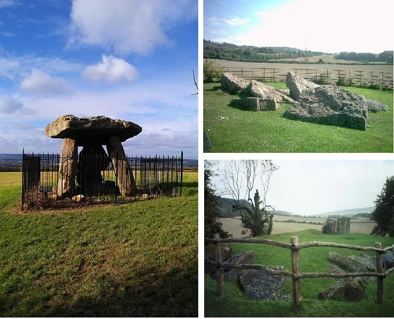
White Horse Stone — Two megaliths near Aylesford, Kent, England.

Wikimedia Commons contributors — see linked file page for photographer and licence licence
Plan your visit
- Typical visit
- 1 h–2 h
- Nearest railway station
- Aylesford · 3.7 km
- Free entry
- Dog-friendly
About
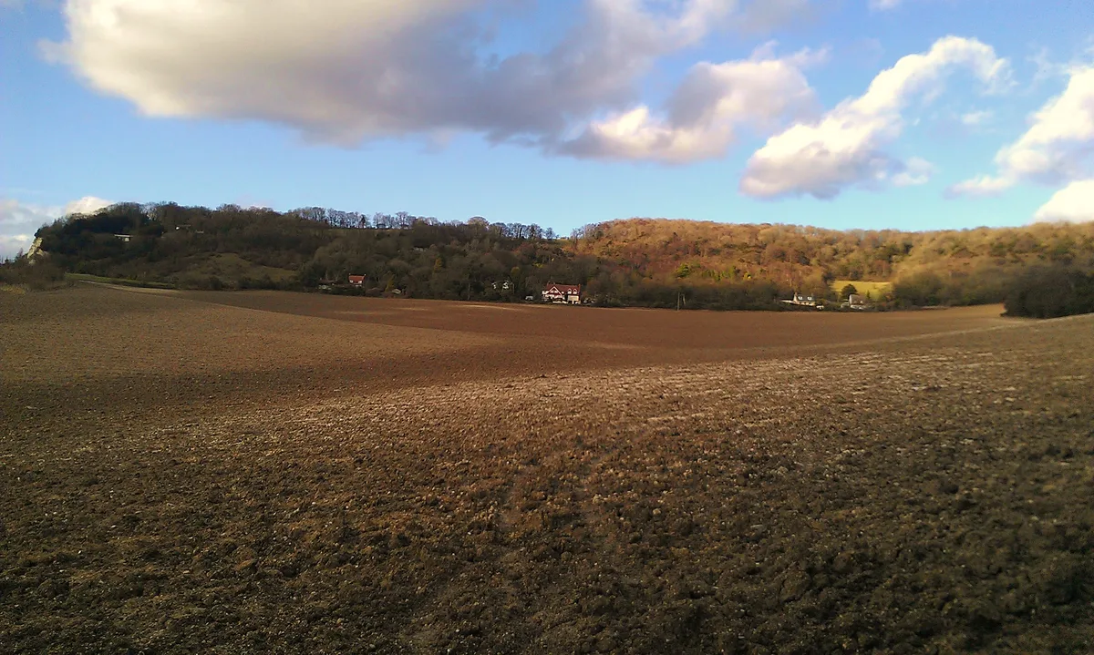
White Horse Stone is a hill fort in the United Kingdom. Wikidata describes it as: "Two megaliths near Aylesford, Kent, England". Coordinates: 51.3153°, 0.5147°.
Photo gallery
Protected designations
- Site of Special Scientific Interest: Wouldham to Detling Escarpment SSSI
- Area of Outstanding Natural Beauty: Kent Downs
Designations sourced from Natural England open data under OGL v3.
From the Wikipedia article
The White Horse Stone is a name given to two separate sarsen megaliths on the slopes of Blue Bell Hill, near the village of Aylesford in the south-eastern English county of Kent. The Lower White Horse Stone was destroyed prior to 1834, at which time the surviving Upper White Horse Stone took on its name and folkloric associations. Various archaeologists have suggested—although not proven—that the stones were each part of chambered long barrows constructed in the fourth millennium BC, during Britain's Early Neolithic period. If the White Horse Stones were originally components of chambered long barrows, then they would have been erected by pastoralist communities shortly after the introduction of agriculture to Britain from continental Europe. Long-barrow building was an architectural tradition widespread across Neolithic Europe although comprised various localised regional variants; one of these was in the vicinity of the River Medway, examples of which are now known as the Medway Megaliths. The White Horse Stones lie on the eastern side of the river, along with the chambered long barrows of Little Kit's Coty House, Kit's Coty House, the (now destroyed) Smythe's Megalith, and the Coffin Stone, which may be a part of a fourth. Three other examples, the Coldrum Long Barrow, Addington Long Barrow, and Chestnuts Long Barrow, remain on the western side of the river. Excavation has revealed the existence of an Early Neolithic longhouse near to the stone. By the 19th century, antiquarians were speculating that the Lower White Horse Stone may have taken its name from the White Horse of Kent, which they in turn believed was the flag of the legendary fifth-century Anglo-Saxon warriors Hengest and Horsa. Subsequent historical research has not accepted this interpretation. After the stone was destroyed, the stories associated with it were transposed to a nearby sarsen boulder, which became known as the Upper White Horse Stone. Since at least the 1980s, the latter has been…
Excerpt from Wikipedia under CC BY-SA 4.0. See the source article linked in Sources below.
- Coordinates
- 51.3153, 0.5147
- County
- Kent
- District
- Tonbridge and Malling
- Parish
- Aylesford
- Postcode
- ME20 7EE
- Parliamentary constituency
- Chatham and Aylesford
- Nearest railway station
- Aylesford — 3.7 km
Sources
- wikidata: Q7994824 (CC0)
- wikipedia: White Horse Stone (CC BY-SA 4.0)
- commons: Upper White Horse Stone.jpg (CC BY-SA 4.0)
Other places nearby
Loading nearby places…
Nearby
 📷 5
📷 5Hill forts · London
Smythe's Megalith
Smythe's Megalith — neolithic monument in Kent, England.
 📷 5
📷 5Parks · London
Westfield Wood
Westfield Wood — park in United Kingdom.
 📷 5
📷 5Historic houses · London
Little Kit's Coty House
Little Kit's Coty House — a other in england-london, United Kingdom.
 📷 5
📷 5Memorials & monuments · South East England
Kit's Coty House
Kit's Coty House or Kit's Coty is a chambered long barrow near the village of Aylesford in the southeastern English county of Kent. Constructed circa 4000 BCE, during the Early Neolithic period of Bri
 📷 5
📷 5Museums · London
Medway megaliths
Medway megaliths — group of long barrows in Kent, England.
 📷 5
📷 5Archaeological sites · London
Tottington Stone
Tottington Stone — a archaeological in england-london, United Kingdom.
More places in this region
 📷 5
📷 5Hill forts · London
Ankerwycke Priory
Ankerwycke Priory — Benedictine nunnery with associated moat and fishponds.
 📷 5
📷 5Hill forts · London
Bartlow Hills
Bartlow Hills — Roman tumuli cemetery in Bartlow (Cambridgeshire, UK).
 📷 5
📷 5Hill forts · London
Bedford Castle
Bedford Castle — castle in Bedfordshire, England, UK.
.jpg?width=1200) 📷 5
📷 5Hill forts · London
Beech Bottom Dyke
Beech Bottom Dyke — Iron Age ditch in St Albans, Hertfordshire, England, UK.
Frequently asked questions
- Where is White Horse Stone?
- White Horse Stone is in Kent, London, United Kingdom (postcode ME20 7EE), in the parish of Aylesford.
- Is White Horse Stone a protected site?
- Yes — White Horse Stone is part of the Wouldham to Detling Escarpment SSSI Site of Special Scientific Interest and the Kent Downs National Landscape (AONB).
- Is White Horse Stone free to visit?
- Yes, White Horse Stone is free to enter.
- How do I get to White Horse Stone?
- The nearest railway station is Aylesford, about 3.7 km away. Drivers can navigate to postcode ME20 7EE.