Mountains & hills · North West England
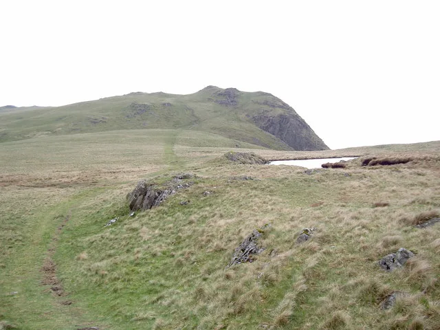
Whin Rigg
Whin Rigg — Named summit at 537 m.

Wikimedia Commons contributors — see linked file page for photographer and licence licence
Plan your visit
- Typical visit
- 3 h–8 h
- Best time of year
- Late spring – early autumn (May–Oct)
- Nearest railway station
- Fisherground Halt · 3.1 km
- Free entry
- Dog-friendly
About
Whin Rigg is a named summit in the United Kingdom. Wikidata describes it as: "Named summit at 537 m.". Coordinates: 54.4202°, -3.3099°.
Photo gallery
Protected designations
- Site of Special Scientific Interest: Wasdale Screes SSSI
Designations sourced from Natural England open data under OGL v3.
From the Wikipedia article
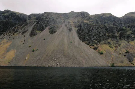
Whin Rigg is a fell in the English Lake District, situated in the western segment of the national park, 22 kilometres (14 miles) south east of the town of Whitehaven. It reaches only a modest altitude of 535 m (1,755 ft) but is part of one of the Lake District’s most dramatic landscapes in that the rugged and impressive Wastwater Screes (also known as "The Screes") fall from the fells summit to Wast Water over 450 m (1,500 ft) below. The fell's name means “gorse covered ridge” and originates from the Old Norse words “Hvin” meaning gorse and “Hryggr” meaning Ridge.
Excerpt from Wikipedia under CC BY-SA 4.0. See the source article linked in Sources below.
- Coordinates
- 54.4202, -3.3099
- District
- Cumberland
- Parish
- Eskdale
- Postcode
- CA19 1UF
- Parliamentary constituency
- Barrow and Furness
- Nearest railway station
- Fisherground Halt — 3.1 km
Sources
- osm: n29877961 (ODbL)
- wikipedia: Whin Rigg (CC BY-SA 4.0)
- commons: Whin Rigg - geograph.org.uk - 795785.jpg (CC BY-SA 4.0)
Other places nearby
Loading nearby places…
Nearby
 📷 4
📷 4Natural landmarks · North West England
Whin Rigg
Whin Rigg — mountain in the English Lake District.
Hostels · North West England
YHA Wasdale Hall
YHA Wasdale Hall — a hostel in england north west.
 📷 3
📷 3Natural landmarks · North West England
Illgill Head
Illgill Head — mountain in United Kingdom.
 📷 3
📷 3Mountains & hills · North West England
Illgill Head (summit)
Illgill Head (summit) — Named summit at 608.8 m.
 📷 3
📷 3Stone circles · North West England
White Moss Stone Circles
White Moss Stone Circles — a stone circle in england-north-west, United Kingdom.
 📷 3
📷 3Archaeological sites · North West England
Boat How Settlement
Boat How Settlement — a archaeological in england-north-west, United Kingdom.
More mountains in this region
 📷 3
📷 3Mountains & hills · North West England
Allen Crags
Allen Crags — Named summit at 785 m.
 📷 3
📷 3Mountains & hills · North West England
Alum Pot
Alum Pot — Open shaft pothole in North Yorkshire.
 📷 3
📷 3Mountains & hills · North West England
Arnside Knott
Arnside Knott — Named summit at 159 m.
 📷 3
📷 3Mountains & hills · North West England
Aye Gill Pike
Aye Gill Pike — Named summit at 556.3 m.
Frequently asked questions
- Where is Whin Rigg?
- Whin Rigg is in North-West England, United Kingdom (postcode CA19 1UF), in the parish of Eskdale.
- Is Whin Rigg a protected site?
- Yes — Whin Rigg is part of the Wasdale Screes SSSI Site of Special Scientific Interest.
- Is Whin Rigg free to visit?
- Yes, Whin Rigg is free to enter.
- How do I get to Whin Rigg?
- The nearest railway station is Fisherground Halt, about 3.1 km away. Drivers can navigate to postcode CA19 1UF.