Natural landmarks · North West England
Illgill Head
Illgill Head — mountain in United Kingdom.

Wikimedia Commons contributors — see linked file page for photographer and licence licence
Plan your visit
- Typical visit
- 1 h–2 h
- Nearest railway station
- Dalegarth · 4.2 km
- Free entry
- Dog-friendly
About
Illgill Head is a named natural landmark in the United Kingdom. Wikidata describes it as: "mountain in United Kingdom". Coordinates: 54.4327°, -3.2826°.
Photo gallery
Protected designations
- Site of Special Scientific Interest: Wast Water SSSI
- Site of Special Scientific Interest: Wasdale Screes SSSI
Designations sourced from Natural England open data under OGL v3.
From the Wikipedia article
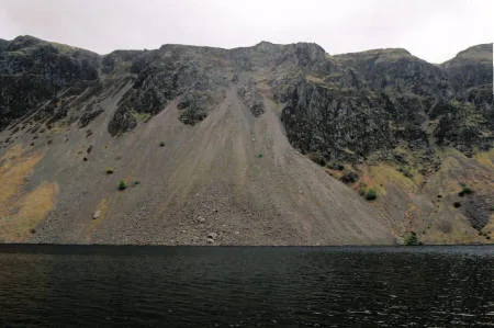
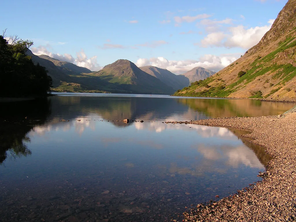
Illgill Head is a fell in the English Lake District. It is known more commonly as the northern portion of the Wastwater Screes. The fell is 609 metres (1,998 ft) high and stands along the south-east shore of Wastwater, the deepest lake in England.
Excerpt from Wikipedia under CC BY-SA 4.0. See the source article linked in Sources below.
- Coordinates
- 54.4327, -3.2826
- Address
- Cumbria, England
- Nearest railway station
- Dalegarth — 4.2 km
Sources
- wikidata: Q5999112 (CC0)
- wikipedia: Illgill Head (CC BY-SA 4.0)
- commons: Illgill Head screes.jpg (CC BY-SA 4.0)
Other places nearby
Loading nearby places…
Nearby
 📷 3
📷 3Mountains & hills · North West England
Illgill Head (summit)
Illgill Head (summit) — Named summit at 608.8 m.
 ★ Iconic📷 4
Wild swimming spots · North West England
Wast Water
England's deepest lake — 79m deep, iconic view, popular wild swim.
 📷 3
📷 3Castles · North West England
Maiden Castle Cairn
Maiden Castle Cairn — a castle in england-north-west, United Kingdom.
 📷 3
📷 3Archaeological sites · North West England
Boat How Settlement
Boat How Settlement — a archaeological in england-north-west, United Kingdom.
 📷 4
📷 4Mountains & hills · North West England
Whin Rigg
Whin Rigg — Named summit at 537 m.
 📷 4
📷 4Natural landmarks · North West England
Whin Rigg
Whin Rigg — mountain in the English Lake District.
More natural landmarks in this region
 ★ Iconic📷 4
Natural landmarks · North West England
Coniston Water
Lake District lake — Swallows and Amazons setting and Donald Campbell water-speed history.
 📷 3
📷 3Natural landmarks · North West England
Elter Water
Elter Water — lake in the United Kingdom.
 📷 3
📷 3Natural landmarks · North West England
Esthwaite Water
Esthwaite Water — lake in the United Kingdom.
 Flagship📷 5
Natural landmarks · North West England
Semerwater
Semerwater — lake in North Yorkshire, England, UK.
Frequently asked questions
- Where is Illgill Head?
- Illgill Head is in North-West England, United Kingdom.
- Is Illgill Head a protected site?
- Yes — Illgill Head is part of the Wast Water SSSI Site of Special Scientific Interest and the Wasdale Screes SSSI Site of Special Scientific Interest.
- Is Illgill Head free to visit?
- Yes, Illgill Head is free to enter.
- How do I get to Illgill Head?
- The nearest railway station is Dalegarth, about 4.2 km away.