Mountains & hills · Central Scotland
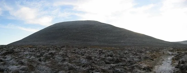
West Cairn Hill
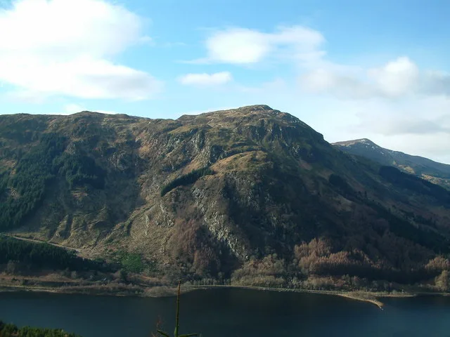
West Cairn Hill — Named summit at 562 m.

Wikimedia Commons contributors — see linked file page for photographer and licence licence
Plan your visit
- Typical visit
- 3 h–8 h
- Best time of year
- Late spring – early autumn (May–Oct)
- Nearest railway station
- Livingston South · 8.3 km
- Free entry
- Dog-friendly
About
West Cairn Hill is a named summit in the United Kingdom. Wikidata describes it as: "Named summit at 562 m.". Coordinates: 55.8106°, -3.4259°.
Photo gallery
From the Wikipedia article
West Cairn Hill is a hill in the Pentland Hills range of Scotland. With a height of 562 m (1,844 ft), it is the fifth highest elevation and lies on the western flank of the approximately 20 mi (32 km) long chain of hills. The border between the council areas of the Scottish Borders and West Lothian runs over the knoll. The closest settlement is the hamlet of Carlops around six kilometers to the southeast. West Calder is nine kilometers to the northwest and Penicuik is eleven kilometers to the east. The Cauldstane Slap pass runs at the saddle point between West and East Cairn Hill. The surrounding hills include Colzium Hill and Torweaving Hill in the southwest, East Cairn Hill in the northeast, and Wether Law in the east.
Excerpt from Wikipedia under CC BY-SA 4.0. See the source article linked in Sources below.
- Coordinates
- 55.8106, -3.4259
- Address
- Scottish Borders and West Lothian, Scotland
- Nearest railway station
- Livingston South — 8.3 km
Sources
- osm: n363604947 (ODbL)
- wikipedia: West Cairn Hill (CC BY-SA 4.0)
- commons: West Cairn Hill - geograph.org.uk - 32138.jpg (CC BY-SA 4.0)
Other places nearby
Loading nearby places…
Nearby
Mountain bike trails · Central Scotland
Little Vantage to Baddinsgill
Little Vantage to Baddinsgill — a mtb trail in scotland central.
 📷 3
📷 3Mountains & hills · Central Scotland
East Cairn Hill
East Cairn Hill — Named summit at 567 m.
 📷 3
📷 3Castles · Central Scotland
Cairns Castle
Cairns Castle — a castle in scotland-central, United Kingdom.
 📷 3
📷 3Reservoirs & lochs · Central Scotland
Harperrig Reservoir
Harperrig Reservoir — artificial lake in West Lothian, Scotland, UK, on the Water of Leith.
 📷 3
📷 3Reservoirs & lochs · Central Scotland
Baddinsgill Reservoir
Baddinsgill Reservoir — artificial lake in Scottish Borders, Scotland, UK, on Lyne Water.
 📷 3
📷 3Memorials & monuments · Central Scotland
Bore Stane
Bore Stane — a memorial in scotland-central, United Kingdom.
More mountains in this region
 📷 3
📷 3Mountains & hills · Central Scotland
Abbey Hill
Abbey Hill — Named summit at 278 m.
 📷 3
📷 3Mountains & hills · Central Scotland
Aberlady Bay
Aberlady Bay — bay on the north coast of East Lothian, Scotland, UK.
 📷 3
📷 3Mountains & hills · Central Scotland
Allermuir Hill
Allermuir Hill — Named summit at 493 m.
 📷 3
📷 3Mountains & hills · Central Scotland
Ardnandave
Ardnandave — Named summit at 715 m.
Frequently asked questions
- Where is West Cairn Hill?
- West Cairn Hill is in Central Scotland, in the United Kingdom — coordinates 55.8106°, -3.4259°. The nearest railway station is Livingston South, around 8.3 km away.
- Is West Cairn Hill free to visit?
- Yes — admission to West Cairn Hill is free.