Caves · North West England
Weathercote Cave
Weathercote Cave is a cave in the United Kingdom.

Wikimedia Commons contributors — see linked file page for photographer and licence licence
Plan your visit
- Typical visit
- 45 min–1.5 h
- Nearest railway station
- Ribblehead · 3.0 km
- Free entry
- Dog-friendly
About
Weathercote Cave is a named cave entrance in the United Kingdom. Coordinates: 54.1931°, -2.4009°. This entry is part of The Great Britain Guide, a free, ad-free, open-data tourist directory.
Photo gallery
Protected designations
- Site of Special Scientific Interest: Ingleborough SSSI
- Site of Special Scientific Interest: Whernside SSSI
- National Nature Reserve: INGLEBOROUGH
Designations sourced from Natural England open data under OGL v3.
From the Wikipedia article
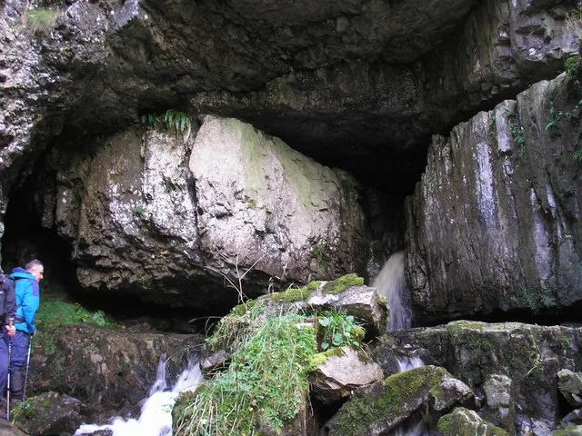
Weathercote Cave is a natural solutional cave in Chapel-le-Dale, North Yorkshire, England. It has been renowned as a natural curiosity since the eighteenth century, and was accessible to paying visitors until 1971. The entrance is a large shaft about 20 metres (66 ft) deep, dominated by a waterfall entering at one end. It lies within the designated Ingleborough Site of Special Scientific Interest.
Excerpt from Wikipedia under CC BY-SA 4.0. See the source article linked in Sources below.
Background
History
Weathercote Cave was first described in detail by Richard Pococke who undertook a tour of Yorkshire in 1751. He said that it was "one of the most extraordinary and scenes I have ever beheld". It was drawn to the public's attention in 1780 by John Hutton in an appendix to Thomas West's "A Guide to the Lakes", who described it as "the most surprising natural curiosity in the island of Great Britain". Thereafter, it became a destination for those seeking the picturesque, and is featured in most later guide books of the area. J. M. W. Turner visited the cave in 1808, and made a number of sketches and painted a view from the bottom, and in 1816 he returned when he painted the view from the top…
Description
The entrance lies in the floor of the Chapel-le-Dale valley below the Hill Inn, and is enclosed by a substantial wall. A path leads from a doorway in the wall to the open shaft, some 61 m long and up to 15 m wide. The underground Winterscales Beck emerges from a passage at the north end, and falls some 20 m down the shaft. The top of the waterfall is overhung by a massive wedged boulder known as Mohammed's Coffin. The name is an allusion to the legend that through the use of magnets or lodestones, Mohammed's coffin was suspended in mid-air in his tomb in Mecca. At the near end of the shaft, a flight of 51 steps descends beneath a natural rock arch, to the bottom, where a number of short…
Sourced from Wikipedia under CC BY-SA 4.0.
- Coordinates
- 54.1931, -2.4009
- District
- North Yorkshire
- Parish
- Ingleton
- Postcode
- LA6 3AR
- Parliamentary constituency
- Skipton and Ripon
- Nearest railway station
- Ribblehead — 3 km
- Official site
- cncc.org.uk
Sources
- osm: n1572973202 (ODbL)
- wikipedia: Weathercote Cave (CC BY-SA 4.0)
- commons: Weathercote Cave.jpg (CC BY-SA 4.0)
Other places nearby
Loading nearby places…
Nearby
 📷 5
📷 5Caves · North West England
Jingle Pot
Jingle Pot — a cave broad in england-north-west, United Kingdom.
 📷 3
📷 3Public art & sculpture · North West England
"Boggard" Statue
"Boggard" Statue — a public art in england-north-west, United Kingdom.
 📷 5
📷 5Caves · North West England
Hurtle Pot
Hurtle Pot — a cave broad in england-north-west, United Kingdom.
Campsites · North West England
Philpin Farm Campsite
Philpin Farm Campsite — a campsite in england north west.
 📷 5
📷 5Caves · North West England
Midge Hole
Midge Hole — a cave broad in england-north-west, United Kingdom.
 📷 5
📷 5Mountains & hills · North West England
Great Douk Cave
Great Douk Cave — cave in North Yorkshire, England.
More caves in this region
 📷 3
📷 3Caves · North West England
Alum Pot
Alum Pot is a cave in the United Kingdom.
 📷 3
📷 3Caves · North West England
Antler Hole
Antler Hole is a cave in the United Kingdom.
 📷 3
📷 3Caves · North West England
Aquamole Pot
Aquamole Pot is a cave in the United Kingdom.
 📷 3
📷 3Caves · North West England
Austwick Beck Head
Austwick Beck Head is a cave in the United Kingdom.
Frequently asked questions
- Where is Weathercote Cave?
- Weathercote Cave is in North-West England, United Kingdom (postcode LA6 3AR), in the parish of Ingleton.
- Is Weathercote Cave a protected site?
- Yes — Weathercote Cave is part of the Ingleborough SSSI Site of Special Scientific Interest and the Whernside SSSI Site of Special Scientific Interest.
- Is Weathercote Cave free to visit?
- Yes, Weathercote Cave is free to enter.
- How do I get to Weathercote Cave?
- The nearest railway station is Ribblehead, about 3.0 km away. Drivers can navigate to postcode LA6 3AR.