Mountains & hills · South East England
W/L Cave
W/L Cave — cave in Somerset, England.

Wikimedia Commons contributors — see linked file page for photographer and licence licence
Plan your visit
- Typical visit
- 3 h–8 h
- Best time of year
- Late spring – early autumn (May–Oct)
- Nearest railway station
- Cranmore · 4.7 km
- Free entry
- Dog-friendly
About
W/L Cave is a named summit in the United Kingdom. Part of Fairy Cave Quarry. Wikidata describes it as: "cave in Somerset, England". Coordinates: 51.2262°, -2.4919°.
Photo gallery
Protected designations
- Site of Special Scientific Interest: St. Dunstan's Well Catchment SSSI
Designations sourced from Natural England open data under OGL v3.
From the Wikipedia article
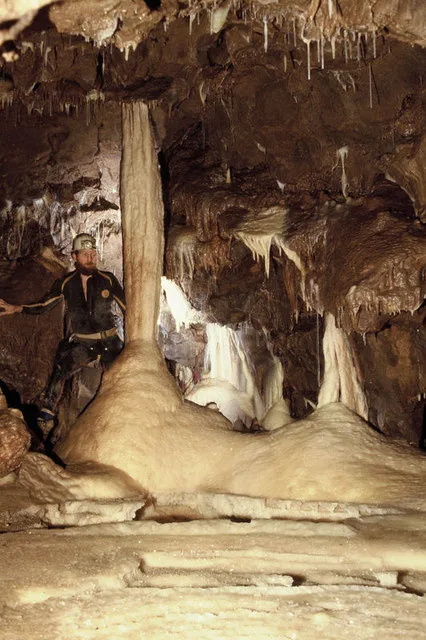
W/L Cave is part of the Fairy Cave Quarry group of caves between Stoke St Michael and Oakhill in the limestone of the Mendip Hills, in Somerset, England. It is named after the initials of its discoverers, Bob Whitaker and Jerry Lavis, was first entered in the summer of 1967. It was the first significant cave to be discovered after the destruction of Balch Cave in the same (Fairy Cave) quarry. Although short it was extremely well decorated with calcite formations and ended in a large chamber with a magnificent side grotto dubbed Pink Pool Chamber. It is almost certainly part of the Balch Cave system and is the link between Balch Cave and the other systems in Fairy Cave Quarry namely Shatter Cave and Withyhill Cave. The link was proved by a digging project conducted by Pete Rose and Nick Chipchase of the Cerberus Spelaeological Society, the HQ of which club used to lie adjacent to the quarry in cottages owned by the quarry company. Pink Pool Chamber is linked to the first chamber in Shatter Cave by a narrow passage opened by blasting by the above named cavers.
Excerpt from Wikipedia under CC BY-SA 4.0. See the source article linked in Sources below.
- Coordinates
- 51.2262, -2.4919
- District
- Somerset
- Parish
- Stoke St Michael
- Postcode
- BA3 5GJ
- Parliamentary constituency
- Frome and East Somerset
- Nearest railway station
- Cranmore — 4.7 km
Sources
- wikidata: Q7946092 (CC0)
- wikipedia: W/L Cave (CC BY-SA 4.0)
- commons: Geograph 2349812 W L Cave.jpg (CC BY-SA 4.0)
Other places nearby
Loading nearby places…
Nearby
 📷 5
📷 5Mountains & hills · South East England
Shatter Cave
Shatter Cave — cave in Somerset, England.
 📷 5
📷 5Mountains & hills · South East England
Balch Cave
Balch Cave — Cave in Somerset, England.
 📷 5
📷 5Caves · South East England
Hillier's Cave
Hillier's Cave is a cave in the United Kingdom.
 📷 5
📷 5Viewpoints · South East England
Ten Minute Arete
Ten Minute Arete is a viewpoint in the United Kingdom.
Campsites · South East England
ba35hp
ba35hp — a campsite in england south east.
 📷 5
📷 5Caves · South East England
Stoke Lane Slocker
Stoke Lane Slocker is a cave in the United Kingdom.
More mountains in this region
 📷 5
📷 5Mountains & hills · South East England
Alum Bay
Alum Bay is a mountain or hill in the United Kingdom.
 📷 5
📷 5Mountains & hills · South East England
Arish Mell
Arish Mell — bay in Dorset, England.
 📷 5
📷 5Mountains & hills · South East England
Balaclava Bay
Balaclava Bay — bay in Dorset, England.
📷 5Mountains & hills · South East England
Balch Cave
Balch Cave — Cave in Somerset, England.
Frequently asked questions
- Where is W/L Cave?
- W/L Cave is in South-East England, United Kingdom (postcode BA3 5GJ), in the parish of Stoke St Michael.
- Is W/L Cave a protected site?
- Yes — W/L Cave is part of the St. Dunstan's Well Catchment SSSI Site of Special Scientific Interest.
- Is W/L Cave free to visit?
- Yes, W/L Cave is free to enter.
- How do I get to W/L Cave?
- The nearest railway station is Cranmore, about 4.7 km away. Drivers can navigate to postcode BA3 5GJ.