Mountains & hills · South East England
Shatter Cave
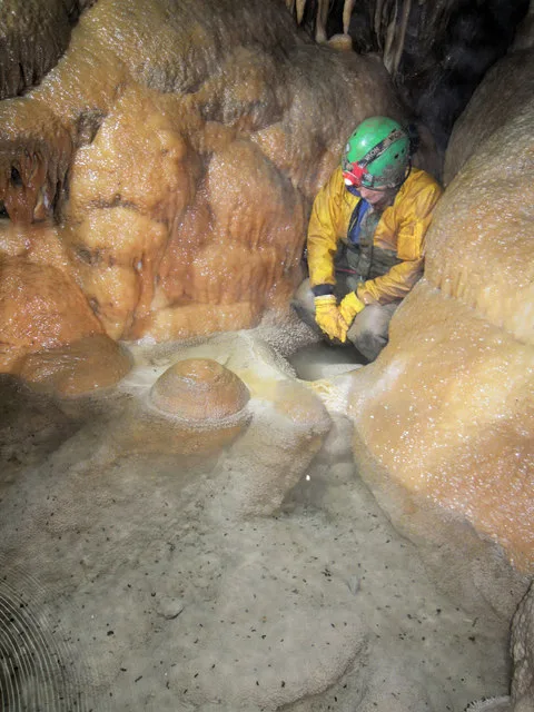
Shatter Cave — cave in Somerset, England.

Wikimedia Commons contributors — see linked file page for photographer and licence licence
Plan your visit
- Typical visit
- 3 h–8 h
- Best time of year
- Late spring – early autumn (May–Oct)
- Nearest railway station
- Cranmore · 4.6 km
- Free entry
- Dog-friendly
About
Shatter Cave is a named summit in the United Kingdom. Part of Fairy Cave Quarry. Wikidata describes it as: "cave in Somerset, England". Coordinates: 51.2259°, -2.4921°.
Photo gallery
Protected designations
- Site of Special Scientific Interest: St. Dunstan's Well Catchment SSSI
Designations sourced from Natural England open data under OGL v3.
From the Wikipedia article
Shatter Cave is a cave in Fairy Cave Quarry, near Stoke St Michael in the limestone of the Mendip Hills, in Somerset, England. It falls within the St. Dunstan's Well Catchment Site of Special Scientific Interest. The name commemorates the damage, done by blasting in the quarry, to some of the decoration within the cave.
Excerpt from Wikipedia under CC BY-SA 4.0. See the source article linked in Sources below.
Background
Description
Shatter Cave has been described as being one of the finest decorated caves in Britain in terms of their sheer abundance of pure white and translucent calcite deposits. The floor of Diesel Chamber includes some fine gours, Helicite Rift contains heligmites and a stalactite curtain, and Pillar Chamber contains a 3 m high white pillar as well as one of the finest crystalline gour floors in Great Britain. Tor Chamber, Portcullis Grottoes and Pisa Passage are also highly decorated.
Visiting
The Fairy Caves Management Committee administers the access to this cave on behalf of the quarry owners. In order to protect the calcite formations, novices are not allowed to enter Shatter Cave.
Sourced from Wikipedia under CC BY-SA 4.0.
- Coordinates
- 51.2259, -2.4921
- District
- Somerset
- Parish
- Stoke St Michael
- Postcode
- BA3 5GJ
- Parliamentary constituency
- Frome and East Somerset
- Nearest railway station
- Cranmore — 4.6 km
Sources
- wikidata: Q7490683 (CC0)
- wikipedia: Shatter Cave (CC BY-SA 4.0)
- commons: Shatter Cave.jpg (CC BY-SA 4.0)
Other places nearby
Loading nearby places…
Nearby
 📷 5
📷 5Mountains & hills · South East England
Balch Cave
Balch Cave — Cave in Somerset, England.
 📷 5
📷 5Mountains & hills · South East England
W/L Cave
W/L Cave — cave in Somerset, England.
 📷 5
📷 5Caves · South East England
Hillier's Cave
Hillier's Cave is a cave in the United Kingdom.
 📷 5
📷 5Viewpoints · South East England
Ten Minute Arete
Ten Minute Arete is a viewpoint in the United Kingdom.
Campsites · South East England
ba35hp
ba35hp — a campsite in england south east.
 📷 5
📷 5Caves · South East England
Stoke Lane Slocker
Stoke Lane Slocker is a cave in the United Kingdom.
More mountains in this region
 📷 5
📷 5Mountains & hills · South East England
Alum Bay
Alum Bay is a mountain or hill in the United Kingdom.
 📷 5
📷 5Mountains & hills · South East England
Arish Mell
Arish Mell — bay in Dorset, England.
 📷 5
📷 5Mountains & hills · South East England
Balaclava Bay
Balaclava Bay — bay in Dorset, England.
📷 5Mountains & hills · South East England
Balch Cave
Balch Cave — Cave in Somerset, England.
Frequently asked questions
- Where is Shatter Cave?
- Shatter Cave is in South-East England, United Kingdom (postcode BA3 5GJ), in the parish of Stoke St Michael.
- Is Shatter Cave a protected site?
- Yes — Shatter Cave is part of the St. Dunstan's Well Catchment SSSI Site of Special Scientific Interest.
- Is Shatter Cave free to visit?
- Yes, Shatter Cave is free to enter.
- How do I get to Shatter Cave?
- The nearest railway station is Cranmore, about 4.6 km away. Drivers can navigate to postcode BA3 5GJ.