Hill forts · Mid Wales
Tŷ Mawr
Tŷ Mawr — house near Castle Caereinion, Powys, Wales.

Wikimedia Commons contributors — see linked file page for photographer and licence licence
Plan your visit
- Typical visit
- 1 h–2 h
- Nearest railway station
- Castle Caereinion · 1.9 km
- Free entry
- Family-friendly
- Dog-friendly
About
Tŷ Mawr is a hill fort in the United Kingdom. Constructed primarily of wood. Heritage designation: Grade I listed building. Wikidata describes it as: "house near Castle Caereinion, Powys, Wales". Coordinates: 52.6307°, -3.2237°.
Photo gallery
Protected designations
- Area of Outstanding Natural Beauty: Shropshire Hills
Designations sourced from Natural England open data under OGL v3.
From the Wikipedia article
Tŷ Mawr is a Grade I-listed timber framed house in the township of Trefnant in the historic parish of Castle Caereinion, Montgomeryshire, Wales. Originally occupied by the Lloyd family, descendants of Alo ap Rhiwallon who had settled in Trefnant in the 13th century, the house was re-discovered in 1971 and fully restored to its late 17th-century appearance in 1997–8. The restoration gained the RICSs "Building of the Year" award in 2000. In 2001, a volume of the Montgomeryshire Collections was devoted to a detailed description of the discovery and the research programme that was carried out on the building. The house is open on an occasional basis or by appointment.
Excerpt from Wikipedia under CC BY-SA 4.0. See the source article linked in Sources below.
Background
History
Descended from the Alo ap Rhiwallon family (who had settled there in the 13th century), the builder of Tŷ Mawr was probably Dafydd ap Gwilym, the great-great-grandson of Alo ap Rhiwallon. The Lloyd family became the principal landowners in the Trefnant and eventually in 1911 all of Trefnant township had been acquired by the Earl of Powis's estates.
Architecture
The limewashed box-framed house, four bays long, sits on a stone platform built into the hillside, under a broad half-hipped roof (now replaced with tiles rather than slates, for which evidence was found in the archaeological excavations thatch). The principal timbers are tree-ring dated to 1460: dendrochronology has also provided dates of 1594, when a first floor was inserted within the hall, and 1631 when the internal timber-framed smoke-hood was added. The two trusses within the hall are a single pair of chamfered wooden speres or posts set in the floor and forming a box-frame which carries the roof, and a pair of arch-braced base-crucks with two tiers of cusped struts above the…
Sourced from Wikipedia under CC BY-SA 4.0.
- Coordinates
- 52.6307, -3.2237
- District
- Powys
- Parish
- Castle Caereinion
- Postcode
- SY21 9AT
- Parliamentary constituency
- Montgomeryshire and Glyndwr
- Nearest railway station
- Castle Caereinion — 1.9 km
Sources
- wikidata: Q15979588 (CC0)
- wikipedia: Tŷ Mawr, Castle Caereinion (CC BY-SA 4.0)
- commons: Tŷ Mawr, Castle Caereinion - geograph.org.uk - 1571886.jpg (CC BY-SA 4.0)
Other places nearby
Loading nearby places…
Nearby
Vineyards · Mid Wales
Lower House Camp
Lower House Camp — a UK vineyard in wales mid, producing English or Welsh wine from cool-climate grape varieties.
 📷 3
📷 3Mountains & hills · Mid Wales
Pen-y-foel
Pen-y-foel — a mountain in wales-mid, United Kingdom, 283 m.
Vineyards · Mid Wales
Pen-y-Foel
Pen-y-Foel — a UK vineyard in wales mid, producing English or Welsh wine from cool-climate grape varieties.
Vineyards · Mid Wales
Bank Farm Enclosure
Bank Farm Enclosure — a UK vineyard in wales mid, producing English or Welsh wine from cool-climate grape varieties.
 📷 2
📷 2Mountains & hills · Mid Wales
Upper Park
Upper Park — a mountain in wales-mid, United Kingdom, 352 m.
 📷 4
📷 4Castles · Mid Wales
Dolarddyn Crossing railway station
Dolarddyn Crossing railway station in Wales Mid, United Kingdom.
More places in this region
 📷 5
📷 5Hill forts · Mid Wales
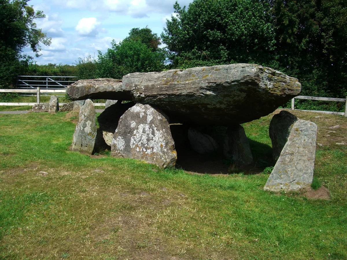
Arthur's Stone, Herefordshire
Arthur's Stone, Herefordshire is a hill fort in the United Kingdom.
 📷 3
📷 3Hill forts · Mid Wales
Aymestrey burial
Aymestrey burial — Beaker cist discovered in Herefordshire, England.
 📷 3
📷 3Hill forts · Mid Wales
Bedd Taliesin
Bedd Taliesin — listed Historic Monument and grave.
 📷 3
📷 3Hill forts · Mid Wales
Bremia
Bremia — archaeological site in Ceredigion, Wales, UK.
Frequently asked questions
- Where is Tŷ Mawr?
- Tŷ Mawr is in Mid Wales, United Kingdom (postcode SY21 9AT), in the parish of Castle Caereinion.
- Is Tŷ Mawr a listed building?
- Tŷ Mawr is officially recognised as Grade I listed building listed.
- Is Tŷ Mawr a protected site?
- Yes — Tŷ Mawr is part of the Shropshire Hills National Landscape (AONB).
- Is Tŷ Mawr free to visit?
- Yes, Tŷ Mawr is free to enter.
- How do I get to Tŷ Mawr?
- The nearest railway station is Castle Caereinion, about 1.9 km away. Drivers can navigate to postcode SY21 9AT.