Natural landmarks · Mid Wales
Trychrug
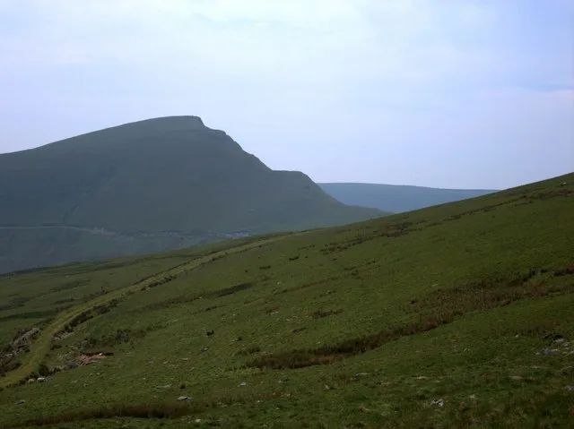
Trychrug — mountain in United Kingdom.

thejackrustles — CC BY-SA 2.0 via Wikimedia Commons licence
Plan your visit
- Typical visit
- 1 h–2 h
- Free entry
- Dog-friendly
About
Trychrug is a named natural landmark in the United Kingdom. Wikidata describes it as: "mountain in United Kingdom". Coordinates: 52.2180°, -4.1340°.
Photo gallery
From the Wikipedia article
Trychrug is a mountain in Ceredigion, Wales, which rises to 343 metres (1,125 ft) high (above sea level) at SN542599 to the north of the valley of the River Aeron and south of the valley of the Afon Wyre. It rises gently from the surrounding land and is farmed almost to the summit which is given over to coniferous forestry plantations. It is crossed, almost at the summit by an ancient drovers road now classified as the B4337 road which gave access from the northern parts of Ceredigion to South Wales before the coastal route down to Aberaeron was developed. Evidence of past use as a drovers road comes from some of the names of the farms adjoining the road such as Llundain East (East London in English). The route crossed the Afon Wyre at the old ford at Llanrhystud, passed over Trychrug before descending to the River Aeron and the crossing at Talsarn before continuing on to Lampeter.
Excerpt from Wikipedia under CC BY-SA 4.0. See the source article linked in Sources below.
- Coordinates
- 52.2180, -4.1340
- District
- Ceredigion
- Parish
- Nantcwnlle
- Postcode
- SA48 8RX
- Parliamentary constituency
- Ceredigion Preseli
Sources
Other places nearby
Loading nearby places…
Nearby
 📷 3
📷 3Historic houses · Mid Wales
Bryn-mynach
Bryn-mynach — a historic house in wales-mid, United Kingdom.
 📷 2
📷 2Historic houses · Mid Wales
Maes-mynach
Maes-mynach — a historic house in wales-mid, United Kingdom.
 📷 3
📷 3Archaeological sites · Mid Wales
Castell
Castell — a archaeological in wales-mid, United Kingdom.
 📷 5
📷 5Historic bridges · Mid Wales
Pont Glanbran
Pont Glanbran — Grade II listed building-listed bridge in wales-mid, United Kingdom.
 📷 4
📷 4Other places · Mid Wales
Cilcennin
Cilcennin in Wales Mid, United Kingdom.
 📷 3
📷 3Historic pubs · Mid Wales
The Commercial Inn
The Commercial Inn — Historic pub — listed building or notable heritage status.
More natural landmarks in this region
 Flagship📷 3
Natural landmarks · Mid Wales
Bomere Pool
Bomere Pool — lake in Shropshire, England, UK.
 📷 3
📷 3Natural landmarks · Mid Wales
Craig-y-llyn
Craig-y-llyn — mountain (622m) in Gwynedd, Wales.
 📷 3
📷 3Natural landmarks · Mid Wales
Bache Hill
Bache Hill — mountain (610m) in Powys.
 📷 3
📷 3Natural landmarks · Mid Wales
Black Hill
Black Hill — mountain in Herefordshire, England, United Kingdom.
Frequently asked questions
- Where is Trychrug?
- Trychrug is in Mid Wales, United Kingdom (postcode SA48 8RX), in the parish of Nantcwnlle.
- Is Trychrug free to visit?
- Yes, Trychrug is free to enter.
- How do I get to Trychrug?
- Drivers can navigate to postcode SA48 8RX. It sits within the Ceredigion Preseli parliamentary constituency.