Towns & cities · London
Trottiscliffe
Trottiscliffe — village and civil parish in Kent, United Kingdom.

Wikimedia Commons contributors — see linked file page for photographer and licence licence
Plan your visit
- Typical visit
- 3 h–6 h
- Nearest railway station
- Borough Green & Wrotham · 4.8 km
- Free entry
- Family-friendly
- Dog-friendly
About
Trottiscliffe is a town, city, village or settlement in the United Kingdom. Recent population estimates put it at around 485 people. Address: ME19. Wikidata describes it as: "village and civil parish in Kent, United Kingdom". Coordinates: 51.3200°, 0.3607°.
Photo gallery
Protected designations
- Site of Special Scientific Interest: Halling to Trottiscliffe Escarpment SSSI
- National Nature Reserve: NORTH KENT WOODS AND DOWNS
- Area of Outstanding Natural Beauty: Kent Downs
Designations sourced from Natural England open data under OGL v3.
From the Wikipedia article
Trottiscliffe ( trottis-cliff) is an English village in the county of Kent about 2.5 miles (4 km) north west of West Malling. It is colloquially known as Trosley to villagers which may be why the name was chosen for Trosley Country Park at the top of the North Downs, which was once part of the Trosley Towers Estate. The spelling Trottesclyve appears with nearby Hallyng in 1396. It was labelled as Trotterscliffe on the Ordnance Survey map published in 1870.
Excerpt from Wikipedia under CC BY-SA 4.0. See the source article linked in Sources below.
- Coordinates
- 51.3200, 0.3607
- County
- Kent
- District
- Tonbridge and Malling
- Parish
- Trottiscliffe
- Postcode
- ME19
- Parliamentary constituency
- Tonbridge
- Population
- 485
- Nearest railway station
- Borough Green & Wrotham — 4.8 km
Sources
- wikidata: Q1920945 (CC0)
- wikipedia: Trottiscliffe (CC BY-SA 4.0)
- commons: The Oast House, The Street-Taylor's Lane, Trottiscliffe, Kent - geograph.org.uk - 821822.jpg (CC BY-SA 4.0)
Other places nearby
Loading nearby places…
Nearby
 📷 5
📷 5Historic churches · London
Church of St Peter and St Paul, Trottiscliffe
Church of St Peter and St Paul, Trottiscliffe — Grade I listed building-listed church in england-london, United Kingdom.
 📷 5
📷 5Museums · London
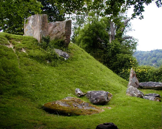
Coldrum Long Barrow
Coldrum Long Barrow — neolithic chambered long barrow near Trottiscliffe, Kent, England, UK.
 📷 5
📷 5Other places · London
Vigo Village
Vigo Village — a other in england-london, United Kingdom.
 📷 5
📷 5Parks · London
Trosley Country Park
Trosley Country Park — park in United Kingdom.
 📷 5
📷 5Burial mounds & barrows · London
Chestnuts Long Barrow
Chestnuts Long Barrow — a burial mound in england-london, United Kingdom.
 📷 5
📷 5Manor houses · London
Linderwood Manor
Linderwood Manor — a manor in england-london, United Kingdom.
More towns in this region
 Flagship📷 10
Towns & cities · London
Aldenham
Aldenham — village and civil parish in Hertfordshire, England.
 Flagship📷 10
Towns & cities · London
Ashdon
Ashdon — village and civil parish in Essex, UK.
 Flagship📷 10
Towns & cities · London
Betchworth
Betchworth — village and civil parish in the Mole Valley district of Surrey, England.
 Flagship📷 10
Towns & cities · London
Boxley
Boxley — village and civil parish in Maidstone District, Kent, England, UK.
Frequently asked questions
- Where is Trottiscliffe?
- Trottiscliffe is in Kent, London, United Kingdom (postcode ME19), in the parish of Trottiscliffe.
- Is Trottiscliffe a protected site?
- Yes — Trottiscliffe is part of the Halling to Trottiscliffe Escarpment SSSI Site of Special Scientific Interest and the NORTH KENT WOODS AND DOWNS National Nature Reserve.
- Is Trottiscliffe free to visit?
- Yes, Trottiscliffe is free to enter.
- How do I get to Trottiscliffe?
- The nearest railway station is Borough Green & Wrotham, about 4.8 km away. Drivers can navigate to postcode ME19.