Historic churches · Scottish Highlands
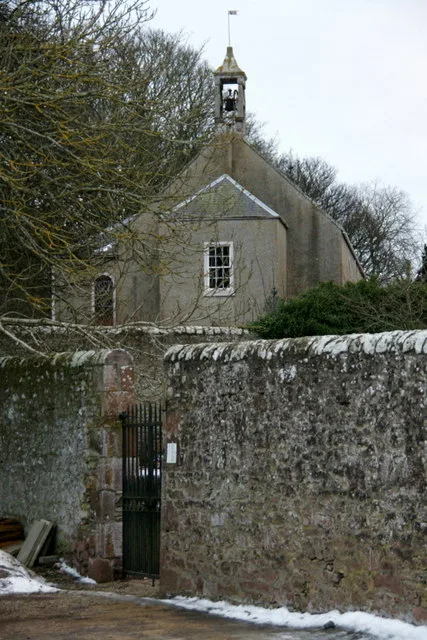
Tomintoul Parish Church and Burial Ground, Main Street, Tomintoul
Tomintoul Parish Church and Burial Ground, Main Street, Tomintoul — category B listed building-listed church in scotland-highlands, United Kingdom.

jeff collins — CC BY-SA 2.0 via Wikimedia Commons licence
Plan your visit
- Typical visit
- 30 min–1 h
- Free entry
About
Tomintoul Parish Church and Burial Ground, Main Street, Tomintoul is a category B listed building-listed church in scotland-highlands, United Kingdom, registered on the Historic Environment Scotland register (entry LB8927). Listed status protects buildings and structures of special architectural or historic interest. See the linked Wikipedia article for further details.
Photo gallery
Heritage listing
Category B Date Added 09/11/1987 Local Authority Moray Planning Authority Moray Parish Kirkmichael (Moray) National Park Cairngorms NGR NJ 16663 19066 Coordinates 316663, 819066 — Thomas Telford, 1826 church, substantially altered and re-fronted, John Robertson, Inverness, 1900. Coursed rubble, tooled dressings; rubble flanks and rear. Street frontage of 4 buttressed bays and gabled projecting porch rising full-height at SW, with pointed doorway in re-entrant angle. Pinnacled buttresses at angles; 1900 tracery and glazing to all windows; stumpy birdcage belfry (1826) at apex, N gable, Tomintoul slate roof. INTERIOR: re-cast and re-modelled in ornate Gothic style; carved oak communion table, reredos and pulpit. Some stained glass. Burial ground to rear with high rubble walls. — Ecclesiastical building in use as such. Quoad Sacra parish of Tomintoul formed 1833. "Stained glass, pulpit and communion table by Messrs Garvie of Aberdeen.
From Historic Environment Scotland under OGL v3.
Place summary
Tomintoul Parish Church and Burial Ground is located on Main Street in Tomintoul, within the Scottish Highlands. This site is designated as a category B listed building, reflecting its architectural and historical significance.
AI-generated from the structured facts on this page (operator, designation, listing, era). Not a substitute for visiting.
- Coordinates
- 57.2547, -3.3830
- District
- Moray
- Postcode
- AB37 9HA
- Parliamentary constituency
- Moray West, Nairn and Strathspey
Sources
- wikidata: Q17827265 (CC0)
Other places nearby
Loading nearby places…
Nearby
 📷 3
📷 3Museums · Scottish Highlands
Tomintoul and Glenlivet Discovery Centre
Tomintoul and Glenlivet Discovery Centre — a museum in scotland-highlands, United Kingdom.
 📷 5
📷 5Towns & cities · Scottish Highlands
Tomintoul
Tomintoul — village in Moray, Scotland, UK.
 📷 5
📷 5Historic churches · Scottish Highlands
St Michael's Roman Catholic Chapel, Tomintoul
St Michael's Roman Catholic Chapel, Tomintoul — category B listed building-listed church in scotland-highlands, United Kingdom.
Hostels · Scottish Highlands
The Smugglers Hostel
The Smugglers Hostel — a hostel in scotland highlands.
 📷 3
📷 3Historic bridges · Scottish Highlands
Conglass Bridge
Conglass Bridge is a historic bridge in the United Kingdom.
 📷 4
📷 4Viewpoints · Scottish Highlands
The Still
The Still is a viewpoint in the United Kingdom.
More places in this region
 📷 3
📷 3Historic churches · Scottish Highlands
Airlie Parish Kirk
Airlie Parish Kirk — church in Angus, Scotland, UK.
 📷 3
📷 3Historic churches · Scottish Highlands
Arbuthnott, Bervie & Kinneff Parish Church
Arbuthnott, Bervie & Kinneff Parish Church — church in Aberdeenshire, Scotland, UK.
 📷 3
📷 3Historic churches · Scottish Highlands
Arnisdale Free Church
Arnisdale Free Church — church in Highland, Scotland, UK.
 📷 3
📷 3Historic churches · Scottish Highlands
Aultbea Free Church
Aultbea Free Church — church in Aultbea, UK.
Frequently asked questions
- Where is Tomintoul Parish Church and Burial Ground, Main Street, Tomintoul?
- Tomintoul Parish Church and Burial Ground, Main Street, Tomintoul is in the Scottish Highlands, United Kingdom (postcode AB37 9HA).
- Is Tomintoul Parish Church and Burial Ground, Main Street, Tomintoul a listed building?
- Tomintoul Parish Church and Burial Ground, Main Street, Tomintoul is officially recognised as category B listed building listed.
- Is Tomintoul Parish Church and Burial Ground, Main Street, Tomintoul free to visit?
- Yes, Tomintoul Parish Church and Burial Ground, Main Street, Tomintoul is free to enter.
- How do I get to Tomintoul Parish Church and Burial Ground, Main Street, Tomintoul?
- Drivers can navigate to postcode AB37 9HA. It sits within the Moray West, Nairn and Strathspey parliamentary constituency.