Towns & cities · East Midlands
Tilney All Saints
Tilney All Saints — village and civil parish in Norfolk, United Kingdom.

Wikimedia Commons contributors — see linked file page for photographer and licence licence
Plan your visit
- Typical visit
- 3 h–6 h
- Nearest railway station
- King's Lynn · 5.9 km
- Free entry
- Family-friendly
- Dog-friendly
About
Tilney All Saints is a town, city, village or settlement in the United Kingdom. It covers approximately 12 km². Recent population estimates put it at around 561 people. Address: PE34. Wikidata describes it as: "village and civil parish in Norfolk, United Kingdom". Coordinates: 52.7380°, 0.3207°.
Photo gallery
From the Wikipedia article
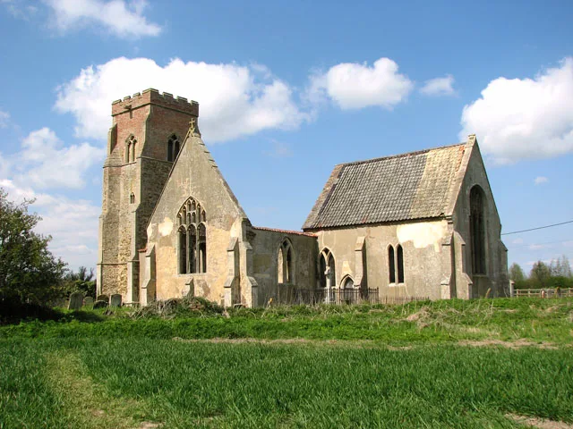
Tilney All Saints is a civil parish in the English county of Norfolk. It covers an area of 11.56 km2 (4.46 sq mi) and had a population of 563 in 230 households at the 2001 census, increasing to 573 at the 2011 Census. For the purposes of local government, it falls within the district of King's Lynn and West Norfolk. The village's name origin is uncertain. 'Useful island' or 'Tila's island'. The Church of All Saints is a Grade I listed building.
Excerpt from Wikipedia under CC BY-SA 4.0. See the source article linked in Sources below.
- Coordinates
- 52.7380, 0.3207
- County
- Norfolk
- District
- King's Lynn and West Norfolk
- Parish
- Tilney All Saints
- Postcode
- PE34
- Parliamentary constituency
- North West Norfolk
- Population
- 561
- Nearest railway station
- King's Lynn — 5.9 km
Sources
- wikidata: Q684699 (CC0)
- wikipedia: Tilney All Saints (CC BY-SA 4.0)
- commons: All Saints, Tilney All Saints, Norfolk - geograph.org.uk - 310393.jpg (CC BY-SA 4.0)
Other places nearby
Loading nearby places…
Nearby
 📷 3
📷 3Public art & sculpture · East Midlands
TilneyAll Saints Village Sign
TilneyAll Saints Village Sign — a public art in england-east-midlands, United Kingdom.
 📷 3
📷 3Memorials & monuments · East Midlands
Tilney All Saints War Memorial Cross
Tilney All Saints War Memorial Cross — Grade II listed building-listed memorial in england-east-midlands, United Kingdom.
 📷 3
📷 3Public art & sculpture · East Midlands
Tilney All Saints Village Sign
Tilney All Saints Village Sign — a public art in england-east-midlands, United Kingdom.
Vineyards · East Midlands
Medieval settlement remains north of Kenwick Farm house
human settlement in Tilney All Saints, King's Lynn and West Norfolk, Norfolk, England, UK
 📷 3
📷 3Historic churches · East Midlands
St Mary's Church
St Mary's Church — church in Tilney St Lawrence, King's Lynn and West Norfolk, Norfolk, England, UK.
 Flagship📷 5
Towns & cities · East Midlands
Terrington St Clement
Terrington St Clement — village and civil parish in Norfolk, UK.
More towns in this region
 Flagship📷 3
Towns & cities · East Midlands
Aldborough
Aldborough — village in Norfolk, England, UK.
 Flagship📷 4
Towns & cities · East Midlands
Alderford
Alderford — village and civil parish in Norfolk, UK.
 Flagship📷 5
Towns & cities · East Midlands
Ashmanhaugh
Ashmanhaugh — village in Norfolk, England, UK.
 Flagship📷 3
Towns & cities · East Midlands
Attlebridge
Attlebridge — a village located in Broadland, United Kingdom.
Frequently asked questions
- Where is Tilney All Saints?
- Tilney All Saints is in Norfolk, the East Midlands, United Kingdom (postcode PE34), in the parish of Tilney All Saints.
- Is Tilney All Saints free to visit?
- Yes, Tilney All Saints is free to enter.
- How do I get to Tilney All Saints?
- The nearest railway station is King's Lynn, about 5.9 km away. Drivers can navigate to postcode PE34.