Archaeological sites · Scottish Lowlands
The vallum and a British settlement between the field boundary west of turret 37a and the road to Steel Rigg car park, in wall miles 37, 38 and 39
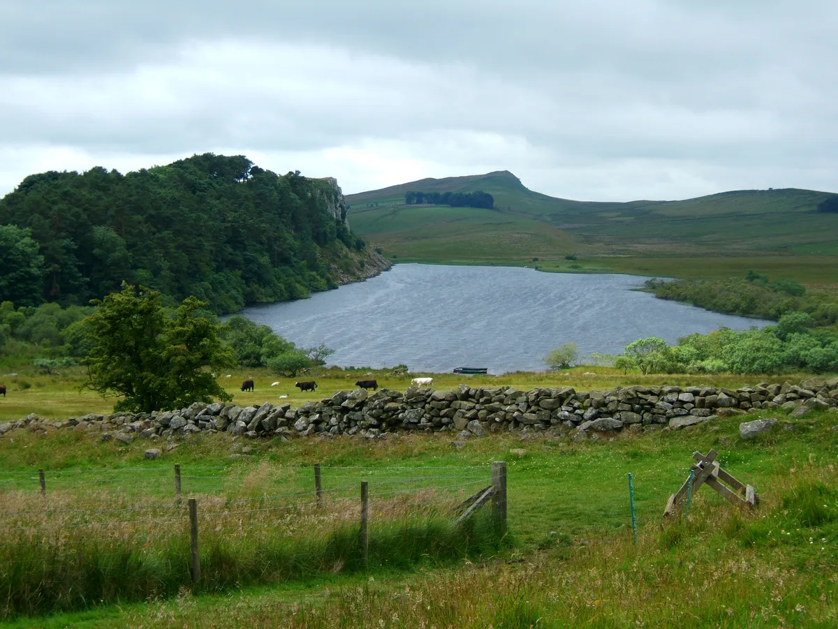
The vallum and a British settlement between the field boundary west of turret 37a and the road to Steel Rigg car park, in wall miles 37, 38 and 39 — archaeological site in Henshaw, Northumberland, England, UK.

Pebble — CC BY-SA 2.0 via Wikimedia Commons licence
Plan your visit
- Typical visit
- 45 min–1.5 h
- Nearest railway station
- Bardon Mill · 3.1 km
- Free entry
- Dog-friendly
About
The vallum and a British settlement between the field boundary west of turret 37a and the road to Steel Rigg car park, in wall miles 37, 38 and 39 is an archaeological site in the United Kingdom. It covers approximately 20 km². Heritage designation: part of UNESCO World Heritage Site. Part of Hadrian's Wall. Wikidata describes it as: "archaeological site in Henshaw, Northumberland, England, UK". Coordinates: 54.9998°, -2.3659°.
Photo gallery
Protected designations
- Site of Special Scientific Interest: River Eden and Tributaries SSSI
- Site of Special Scientific Interest: Roman Wall Escarpments SSSI
Designations sourced from Natural England open data under OGL v3.
Place summary
The vallum and a British settlement are located in the Scottish Lowlands, specifically in the parish of Henshaw, postcode NE47. This archaeological site is part of a UNESCO World Heritage Site and includes designated areas such as the River Eden and Tributaries SSSI, as well as the Roman Wall Escarpments SSSI.
AI-generated from the structured facts on this page (operator, designation, listing, era). Not a substitute for visiting.
- Coordinates
- 54.9998, -2.3659
- District
- Northumberland
- Parish
- Henshaw
- Postcode
- NE47 7AJ
- Parliamentary constituency
- Hexham
- Nearest railway station
- Bardon Mill — 3.1 km
Sources
- wikidata: Q17650634 (CC0)
Other places nearby
Loading nearby places…
Nearby
 📷 5
📷 5Other places · North East England
Sycamore Gap Tree
Sycamore Gap Tree in England North East, United Kingdom.
📷 3Natural landmarks · Scottish Lowlands
Robin Hood Tree
Robin Hood Tree — a other in scotland-lowlands, United Kingdom.
 📷 3
📷 3Natural landmarks · Scottish Lowlands
Crag Lough
Crag Lough — lake in the United Kingdom.
 📷 4
📷 4Castles · North East England
Milecastle 39
Milecastle 39 in England North East, United Kingdom.
 📷 3
📷 3Castles · Scottish Lowlands
Milecastle 39 (Castle Nick)
Milecastle 39 (Castle Nick) — a castle in scotland-lowlands, United Kingdom.
 📷 3
📷 3Viewpoints · Scottish Lowlands
Steel Rigg
Steel Rigg is a viewpoint in the United Kingdom.
More archaeological sites in this region
 📷 3
📷 3Archaeological sites · Scottish Lowlands
Barcombe Hill Roman signal station
Barcombe Hill Roman signal station — archaeological site in Bardon Mill, Northumberland, England, UK.
 📷 3
📷 3Archaeological sites · Scottish Lowlands
Bibra Roman Fort
Bibra Roman Fort — archaeological site in Holme St Cuthbert, Cumberland, Cumbria , England, UK.
 📷 3
📷 3Archaeological sites · Scottish Lowlands
Birdoswald Roman fort and the section of Hadrian's Wall and vallum between the River Irthing and the field boundaries east of milecastle 50
Birdoswald Roman fort and the section of Hadrian's Wall and vallum between the River Irthing and the field boundaries east of milecastle 50 — archaeological site in Waterhead, Carlisle, England, UK.
 📷 3
📷 3Archaeological sites · Scottish Lowlands
Boomby Lane 1 and 2 Roman temporary camps
Boomby Lane 1 and 2 Roman temporary camps — archaeological site in Beaumont, Carlisle, England, UK.
Frequently asked questions
- Where is The vallum and a British settlement between the field boundary west of turret 37a and the road to Steel Rigg car park, in wall miles 37, 38 and 39?
- The vallum and a British settlement between the field boundary west of turret 37a and the road to Steel Rigg car park, in wall miles 37, 38 and 39 is in the Scottish Lowlands, United Kingdom (postcode NE47 7AJ), in the parish of Henshaw.
- Is The vallum and a British settlement between the field boundary west of turret 37a and the road to Steel Rigg car park, in wall miles 37, 38 and 39 a listed building?
- The vallum and a British settlement between the field boundary west of turret 37a and the road to Steel Rigg car park, in wall miles 37, 38 and 39 is officially recognised as part of UNESCO World Heritage Site listed.
- Is The vallum and a British settlement between the field boundary west of turret 37a and the road to Steel Rigg car park, in wall miles 37, 38 and 39 a protected site?
- Yes — The vallum and a British settlement between the field boundary west of turret 37a and the road to Steel Rigg car park, in wall miles 37, 38 and 39 is part of the River Eden and Tributaries SSSI Site of Special Scientific Interest and the Roman Wall Escarpments SSSI Site of Special Scientific Interest.
- How do I get to The vallum and a British settlement between the field boundary west of turret 37a and the road to Steel Rigg car park, in wall miles 37, 38 and 39?
- The nearest railway station is Bardon Mill, about 3.1 km away. Drivers can navigate to postcode NE47 7AJ.