Mountains & hills · Scottish Lowlands
The Cheviot
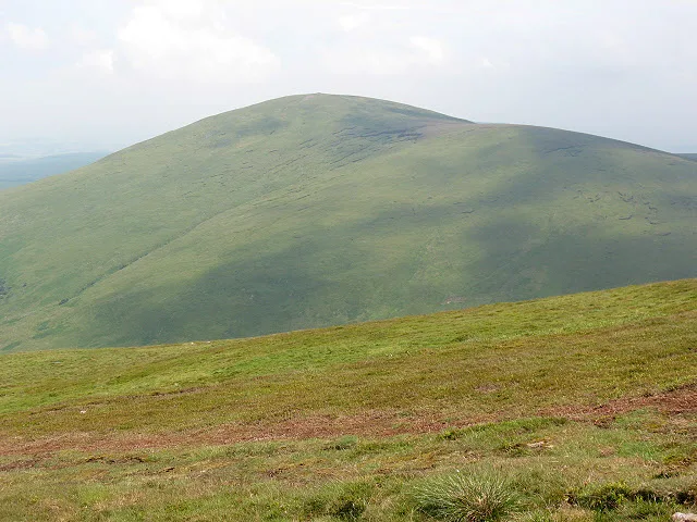
The Cheviot — Named summit at 815 m.

Wikimedia Commons contributors — see linked file page for photographer and licence licence
Plan your visit
- Typical visit
- 3 h–8 h
- Best time of year
- Late spring – early autumn (May–Oct)
- Free entry
- Dog-friendly
About
The Cheviot is a named summit in the United Kingdom. Wikidata describes it as: "Named summit at 815 m.". Coordinates: 55.4785°, -2.1454°.
Photo gallery
Protected designations
- Site of Special Scientific Interest: The Cheviot SSSI
- Site of Special Scientific Interest: Tweed Catchment Rivers - England: Till Catchment SSSI
Designations sourced from Natural England open data under OGL v3.
From the Wikipedia article
The Cheviot () is an extinct volcano and the highest summit in the Cheviot Hills and in the county of Northumberland. Located in the extreme north of England, it is a 1+1⁄4-mile (2-kilometre) walk from the Scottish border and, with a height of 2,674 feet (815 metres) above sea-level, is located on the northernmost few miles of the Pennine Way, before the descent into Kirk Yetholm. The Cheviot was formed when melting in the crust over 390 million years ago gave rise to volcanic activity, producing a stratovolcano and pluton, and it has subsequently sustained intense erosion. Several watercourses radiate from The Cheviot.
Excerpt from Wikipedia under CC BY-SA 4.0. See the source article linked in Sources below.
Background
Visiting
Other than the route via the Pennine Way, most routes up the Cheviot start from the Harthope Burn side to the northeast, which provides the nearest access by road. The summit is around 3 mi from the road-end at Langleeford; across the valley to the east is the rounded peak of Hedgehope. There are routes following the ridges above either side of the valley, and a route that sticks to the valley floor until it climbs to the summit of the Cheviot from the head of the valley. Although the Pennine Way does a 2 mi out-and-back detour to the Cheviot, many walkers who come this way omit it, since the stage (the most northerly) is 29 mi long. approaching the summit of The Cheviot on the flag stone…
Sourced from Wikipedia under CC BY-SA 4.0.
- Coordinates
- 55.4785, -2.1454
- Address
- Chichester |publisher= Summersdale |isbn= 978-1-84-953239-6 |pages= 264–271}}</ref>
- Official site
- www.hill-bagging.co.uk
Sources
- osm: n316697182 (ODbL)
- wikipedia: The Cheviot (CC BY-SA 4.0)
- commons: The Cheviot from Broadhope Hill.jpg (CC BY-SA 4.0)
Featured in this guide
Other places nearby
Loading nearby places…
Nearby
 📷 4
📷 4National parks · North East England
The Cheviot Hills
The Cheviot Hills in England North East, United Kingdom.
 📷 3
📷 3Viewpoints · Scottish Lowlands
Viewpoint at end of trail into Hen Hole
Viewpoint at end of trail into Hen Hole is a viewpoint in the United Kingdom.
Vineyards · Central Scotland
Fawcett Shank defended settlement, 620m SSE of Fleehope
Fawcett Shank defended settlement, 620m SSE of Fleehope — a UK vineyard in scotland central, producing English or Welsh wine from cool-climate grape varieties.
Hostels · Scottish Lowlands
Mounthooly Bunk House
Mounthooly Bunk House — a hostel in scotland lowlands.
 📷 3
📷 3Natural landmarks · Scottish Lowlands
Hedgehope Hill
Hedgehope Hill — mountain in United Kingdom.
 📷 3
📷 3Mountains & hills · Scottish Lowlands
Hedgehope Hill
Hedgehope Hill — Named summit at 714 m.
More mountains in this region
 📷 3
📷 3Mountains & hills · Scottish Lowlands
Andrewhinney Hill
Andrewhinney Hill — Named summit at 677 m.
 📷 3
📷 3Mountains & hills · Scottish Lowlands
Arbory Hill
Arbory Hill — Named summit at 429 m.
 📷 3
📷 3Mountains & hills · Scottish Lowlands
Auchenton Hill ( East Mount Lowther)
Auchenton Hill ( East Mount Lowther) — Named summit at 631 m.
 📷 3
📷 3Mountains & hills · Scottish Lowlands
Bakestall
Bakestall — Named summit at 673.5 m.
Frequently asked questions
- Where is The Cheviot?
- The Cheviot is in the Scottish Lowlands, United Kingdom.
- Is The Cheviot a protected site?
- Yes — The Cheviot is part of the The Cheviot SSSI Site of Special Scientific Interest and the Tweed Catchment Rivers - England: Till Catchment SSSI Site of Special Scientific Interest.
- Is The Cheviot free to visit?
- Yes, The Cheviot is free to enter.