Natural landmarks · Mid Wales
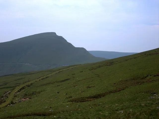
The Begwns
The Begwns in Wales Mid, United Kingdom.

Andrew Jones — CC BY-SA 2.0 via Wikimedia Commons licence
Plan your visit
- Typical visit
- 1 h–2 h
- Free entry
- Dog-friendly
About
The Begwns is a place of interest in Wales Mid, United Kingdom — drawn from open-data sources for visitor reference. See the linked Wikipedia article for the full description.
Photo gallery
From the Wikipedia article
The Begwns, or sometimes The Begwyns, form a small upland area in eastern Powys, Wales. They sit within the communities of Painscastle, Glasbury and Clyro, to the north of a great bend in the course of the Wye valley, west of Hay-on-Wye. ‘Begwns' is a cymricisation of the English ‘beacons’. The Begwns are 1293 acres of common land which was given to the National Trust by the Maesllwch Estate in 1992 and managed for grazing and quiet recreation. The common ranges in elevation from 250m at its lowest to 415m at ‘The Roundabout’, a hilltop wooded feature at the heart of the area. A trig point immediately outside of this enclosure is 1m lower. The trees were planted here to commemorate Queen Victoria's Diamond Jubilee with a wall constructed around them in 1887 for protection. There are a handful of small pools on the common, of which the largest is Monks Pond. These ponds contain the increasingly uncommon aquatic fern, pillwort and other uncommon pond plants like tubular water-dropwort. Numerous springs feed streams which run both north to a small river known as the Bachawy, a left-bank tributary of the Wye, and to the south, directly into the Wye.
Excerpt from Wikipedia under CC BY-SA 4.0. See the source article linked in Sources below.
Background
Visiting
The Begwns are crossed by a number of public footpaths and bridleways though the entire area is mapped as open access providing free access to walkers across all of the land. There are in addition a handful of tarmacked minor public roads cut across the common, together with a number of unmetalled highways shown on Ordnance Survey maps as ‘other routes with public access’ (ORPAs).
Sourced from Wikipedia under CC BY-SA 4.0.
- Coordinates
- 52.0905, -3.2272
- District
- Powys
- Parish
- Painscastle
- Postcode
- LD2 3JN
- Parliamentary constituency
- Brecon, Radnor and Cwm Tawe
Sources
- wikidata: Q85806495 (CC0)
- wikipedia: The Begwns (CC BY-SA 4.0)
Other places nearby
Loading nearby places…
Nearby
Vineyards · Mid Wales
Pentre Jack Settlement
Pentre Jack Settlement — a UK vineyard in wales mid, producing English or Welsh wine from cool-climate grape varieties.
 📷 5
📷 5Historic churches · Mid Wales
Church of St David, Llandewi Fach
Church of St David, Llandewi Fach — Grade II listed building-listed church in wales-mid, United Kingdom.
 📷 5
📷 5Castles · Mid Wales
Painscastle
Painscastle in Wales Mid, United Kingdom.
📷 4Castles · Mid Wales
Painscastle Castle
Painscastle Castle in Wales Mid, United Kingdom.
 📷 4
📷 4Other places · Mid Wales
Painscastle Rural District
Painscastle Rural District in Wales Mid, United Kingdom.
 📷 4
📷 4Historic churches · Mid Wales
Llanbedr
Llanbedr in Wales Mid, United Kingdom.
More natural landmarks in this region
 Flagship📷 3
Natural landmarks · Mid Wales
Bomere Pool
Bomere Pool — lake in Shropshire, England, UK.
 📷 3
📷 3Natural landmarks · Mid Wales
Craig-y-llyn
Craig-y-llyn — mountain (622m) in Gwynedd, Wales.
 📷 3
📷 3Natural landmarks · Mid Wales
Bache Hill
Bache Hill — mountain (610m) in Powys.
 📷 3
📷 3Natural landmarks · Mid Wales
Black Hill
Black Hill — mountain in Herefordshire, England, United Kingdom.
Frequently asked questions
- Where is The Begwns?
- The Begwns is in Mid Wales, United Kingdom (postcode LD2 3JN), in the parish of Painscastle.
- Is The Begwns free to visit?
- Yes, The Begwns is free to enter.
- How do I get to The Begwns?
- Drivers can navigate to postcode LD2 3JN. It sits within the Brecon, Radnor and Cwm Tawe parliamentary constituency.