Museums · South Wales
Tenby
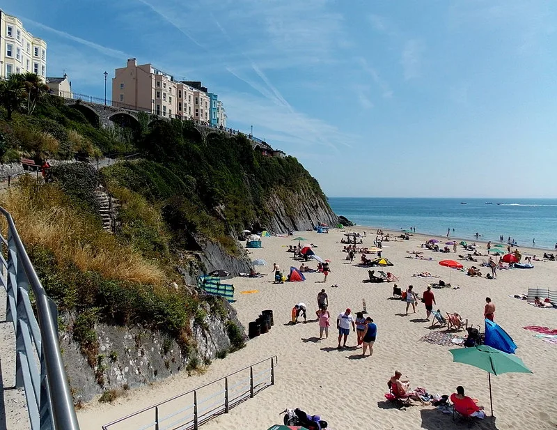
Tenby (Welsh: Dinbych-y-pysgod, lit. 'fortlet of the fish') is a seaside town and community in the county of Pembrokeshire, Wales. It lies within Carmarthen Bay. In 2011, it had a population of 4,696.

Jaggery — CC BY-SA 2.0 via Wikimedia Commons licence
Plan your visit
- Typical visit
- 1.5 h–3 h
- Best time of year
- Year-round
- Family-friendly
- Limited wheelchair access
About
Tenby (Welsh: Dinbych-y-pysgod, lit. 'fortlet of the fish') is a seaside town and community in the county of Pembrokeshire, Wales. It lies within Carmarthen Bay. In 2011, it had a population of 4,696. Notable features include three miles (five kilometres) of sandy beaches and the Pembrokeshire Coast Path, the 13th-century medieval town walls, including the Five Arches barbican gatehouse, Tenby Museum and Art Gallery, the 15th-century St. Mary's Church, and the National Trust's Tudor Merchant's House. Boats sail from Tenby's harbour to the offshore monastic Caldey Island. St Catherine's Island is tidal and has a 19th-century Palmerston Fort. The town has an operating railway station. The A478 road from Cardigan, Ceredigion, connects Tenby with the M4 via the A477, the A40 and the A48 in approximately 40 miles (60 kilometres).
Photo gallery
From the Wikipedia article
Tenby (Welsh: Dinbych-y-pysgod, lit. 'fortlet of the fish') is a seaside town and community in the county of Pembrokeshire, Wales. It lies within Carmarthen Bay. In 2011, it had a population of 4,696. Notable features include three miles (five kilometres) of sandy beaches and the Pembrokeshire Coast Path, the 13th-century medieval town walls, including the Five Arches barbican gatehouse, Tenby Museum and Art Gallery, the 15th-century St. Mary's Church, and the National Trust's Tudor Merchant's House. Boats sail from Tenby's harbour to the offshore monastic Caldey Island. St Catherine's Island is tidal and has a 19th-century Palmerston Fort. The town has an operating railway station. The A478 road from Cardigan, Ceredigion, connects Tenby with the M4 via the A477, the A40 and the A48 in approximately 40 miles (60 kilometres).
Excerpt from Wikipedia under CC BY-SA 4.0. See the source article linked in Sources below.
Background
Description
]] Another war led to a resurgence in Tenby's fortunes. Since 1798, the French General Napoleon Bonaparte had begun conquering Europe, restricting the rich British upper classes from making their Grand Tours to continental spa towns. In 1802, local resident, merchant banker and politician, Sir William Paxton, bought his first property in the old town. From this point onwards, he invested heavily in the area with the full approval of the town council. With the growth in saltwater sea-bathing for health purposes, Paxton engaged engineer James Grier and architect Samuel Pepys Cockerell (the same team who had built his home at Middleton Hall) to create a "fashionable bathing establishment…
Visiting
Attractions include the two sheltered, sandy beaches and the coastal boat trips to Caldey Island. St Catherine's Island is tidal and the site of St Catherine's Fort a 19th-century Palmerston Fort. Tenby has shops, pubs, and restaurants that cater to visitors. The Sunday Times rated Tenby's Castle Beach the best beach in the UK in 2019.
Sourced from Wikipedia under CC BY-SA 4.0.
- Coordinates
- 51.6745, -4.7044
- District
- Pembrokeshire
- Parish
- Tenby
- Postcode
- SA70 7LJ
- Parliamentary constituency
- Mid and South Pembrokeshire
- Official site
- www.aroundtenby.co.uk
Sources
- wikipedia: Tenby (CC BY-SA 4.0)
Featured in this guide
Other places nearby
Loading nearby places…
Nearby
 📷 5
📷 5Memorials & monuments · South Wales
Retaining arches and railings at S end
Retaining arches and railings at S end — Grade II listed building-listed memorial in wales-south, United Kingdom.
 📷 3
📷 3Historic bridges · South Wales
Tenby Viaduct
Tenby Viaduct is a historic bridge in the United Kingdom.
 📷 3
📷 3Theatres · South Wales
Royal Playhouse Cinema
Royal Playhouse Cinema in Wales South, United Kingdom.
 📷 3
📷 3Beaches · South Wales
North Beach
North Beach — beach in Tenby, Wales.
 📷 3
📷 3Theatres · South Wales
Little Theatre
Little Theatre in Wales South, United Kingdom.
 📷 5
📷 5Historic churches · South Wales
St John's English Congregational Church
St John's English Congregational Church — Grade II listed building-listed church in wales-south, United Kingdom.
More museums in this region
 📷 3
📷 3Museums · South Wales
Baked Bean Museum of Excellence
Baked Bean Museum of Excellence — food museum in Wales.
 📷 5
📷 5Museums · South Wales
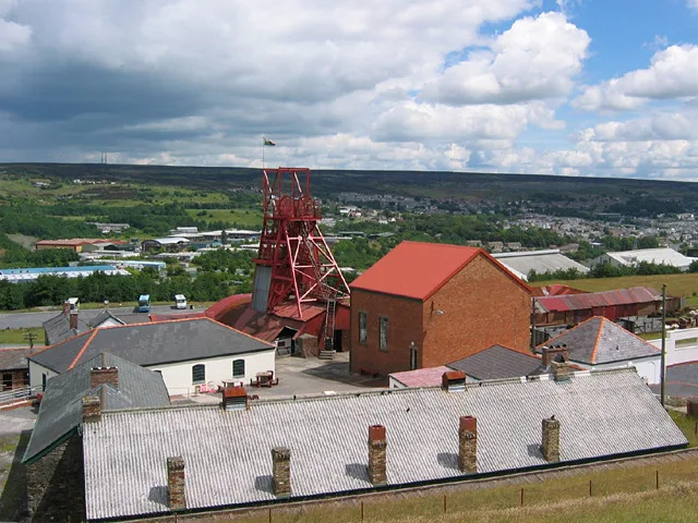
Big Pit National Coal Museum
Big Pit National Coal Museum — former coal mine and industrial heritage museum in Blaenavon in south-east Wales, United Kingdom.
 📷 5
📷 5Museums · South Wales
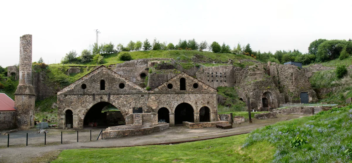
Blaenavon Ironworks
Blaenavon Ironworks — former ironworks transformed into a museum.
 📷 4
📷 4Museums · South Wales
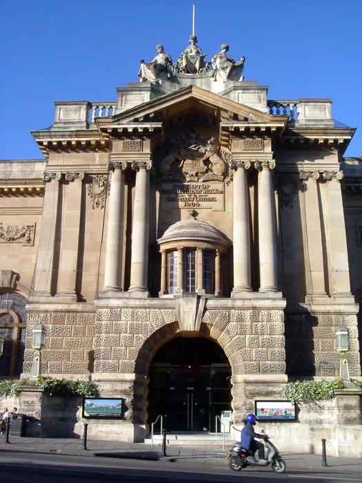
Bristol City Museum & Art Gallery
Bristol City Museum & Art Gallery is a museum in the United Kingdom.
Frequently asked questions
- Where is Tenby?
- Tenby is in South Wales, in the United Kingdom — coordinates 51.6745°, -4.7044°.
- Is Tenby wheelchair accessible?
- Partially — OpenStreetMap notes limited wheelchair access at Tenby. Check ahead for specific facilities.