Natural landmarks · South Wales
Pembrokeshire Coast Path
Also known as: Llwybr Arfordir Sir Benfro, Conair Chósta Sir Benfro, Slighe Costa Sir Benfro
186-mile National Trail around the entire Pembrokeshire coast — Britain's first coastal trail.

Wikimedia Commons licence
Plan your visit
- Typical visit
- 1 h–2 h
- Free entry
- Dog-friendly
About
The Pembrokeshire Coast Path is the 186-mile National Trail (1970) hugging the entire Pembrokeshire coastline from St Dogmaels to Amroth — through Pembrokeshire Coast National Park, taking in red-sandstone cliffs, hidden coves, harbours and the Skomer/Skokholm seabird islands offshore. 11-15 day end-to-end.
Photo gallery
From the Wikipedia article
The Pembrokeshire Coast Path (Welsh: Llwybr Arfordir Sir Benfro), often called the Pembrokeshire Coastal Path, is a designated National Trail in Pembrokeshire, southwest Wales. Established in 1970, it is a 186-mile (299 km) long-distance walking route, mostly at cliff-top level, with a total of 35,000 feet (11,000 m) of ascent and descent. At its highest point – Pen yr afr, on Cemaes Head – it reaches a height of 574 feet (175 m), and at its lowest point – Sandy Haven crossing, near Milford Haven – it is just 6 feet (2 m) above low water. Whilst most of the coastline faces west, it offers – at varying points – coastal views in every direction of the compass. The southern end of the path is at Amroth, Pembrokeshire. The northern end is often regarded as being at Poppit Sands, near St Dogmaels, Pembrokeshire, where the official plaque was originally sited but the path now continues to St Dogmaels, where a new marker was unveiled in July 2009. Here the path links with the Ceredigion Coast Path, which continues northwards. The Pembrokeshire Coast Path forms part of the 870-mile (1,400 km) Wales Coast Path around the whole coast of Wales from Chepstow to the border with Chester, which was officially opened in 2012.
Excerpt from Wikipedia under CC BY-SA 4.0. See the source article linked in Sources below.
Background
History
Following the establishment of the Pembrokeshire Coast National Park in 1952, Welsh naturalist and author Ronald Lockley surveyed a route around the coast. Although there were villages and settlements on the coast, communication between these was largely by boats, and access in the region was generally poor. Lockley's report for the Countryside Commission in 1953 was welcomed and broadly adopted. Some sections of the walk were existing rights-of-way, but the majority were in private hands, necessitating negotiation. Most landowners were in favour, and many benefitted from the erection of new fencing. Even today, however, the path in places detours from the obvious line where landowners were…
Description
The Pembrokeshire Coast Path lies almost entirely within the Pembrokeshire Coast National Park — Britain's only coastal national park. Throughout its length, it covers a range of maritime landscapes, from rugged and steep limestone cliffs and volcanic headlands to sheltered red sandstone coves, flooded glacial valleys, winding estuaries, and wide-open beaches. The path passes 58 beaches and 14 harbours. As far as possible the route runs close to the cliff edge and coast, but this is not possible at all times; on occasion the coast is barely visible where the path briefly detours round industrial or for miles around military areas such as Castlemartin Training Area. Since the construction of…
Sourced from Wikipedia under CC BY-SA 4.0.
- Coordinates
- 51.7333, -5.0667
- District
- Pembrokeshire
- Parish
- Herbrandston
- Postcode
- SA73 3RY
- Parliamentary constituency
- Mid and South Pembrokeshire
Sources
- manual: pembrokeshire-coast-path (manual)
- wikipedia: Pembrokeshire Coast Path (CC BY-SA 4.0)
Featured in these 5 guides
Itinerary
The 5 best UK coastal paths
Long-distance walks from Cornwall to the Pembrokeshire coast.
Itinerary
Pembrokeshire coast in 5 days
Britain's only coastal national park, end to end.
Itinerary
Britain's white cliffs & sea stacks
Ten dramatic chalk and sandstone coastal landmarks.
Itinerary
Britain's best winter walks
Crisp-frost trails for December and January.
Itinerary
Britain's May-blossom walks
Hawthorn, blackthorn, cherry — late spring at peak.
Other places nearby
Loading nearby places…
Nearby
Caravan parks · South Wales
Woody Kiln C.P.
Woody Kiln C.P. — a caravan park in wales south.
Vineyards · South Wales
Capeston Rath
Capeston Rath — a UK vineyard in wales south, producing English or Welsh wine from cool-climate grape varieties.
Vineyards · South Wales
Thornton Rath
Thornton Rath — a UK vineyard in wales south, producing English or Welsh wine from cool-climate grape varieties.
Vineyards · South Wales
Syke Rath
Syke Rath — a UK vineyard in wales south, producing English or Welsh wine from cool-climate grape varieties.
 📷 3
📷 3Beaches · South Wales
Sandy Haven Beach
Sandy Haven Beach is a beach in the United Kingdom.
 📷 3
📷 3Observatories · South Wales
Hakin Observatory
Hakin Observatory — scheduled monument in Wales.
Other natural landmarks from this era
_(cropped).JPG?width=1200) 📷 5
📷 5Natural landmarks · London
George Stuart White
George Stuart White — Public artwork (statue).
 📷 5
📷 5Natural landmarks · London
Homage to Leonardo
Homage to Leonardo — Public artwork (statue).
 📷 5
📷 5Natural landmarks · London
John Keats
John Keats — Public artwork (statue) by Stuart Williamson.
 📷 5
📷 5Natural landmarks · London
José de San Martín
José de San Martín — Public artwork (statue).
More natural landmarks in this region
 📷 3
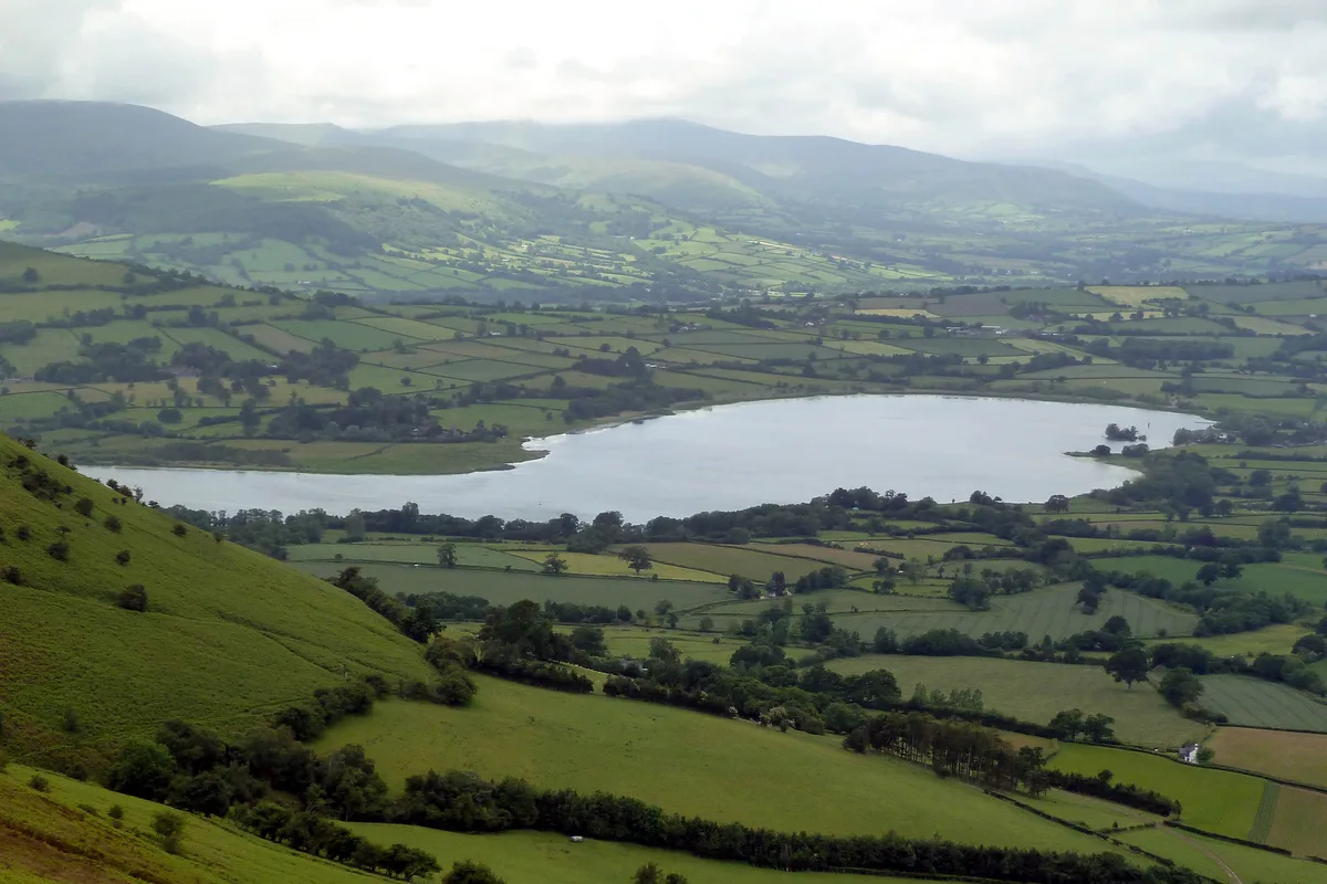
📷 3Natural landmarks · South Wales
Llangorse Lake
Llangorse Lake — lake near Brecon, Powys, Wales, UK.
 📷 3
📷 3Natural landmarks · South Wales
Cefn yr Ystrad
Cefn yr Ystrad — mountain (619m) in Powys.
 📷 3
📷 3Natural landmarks · South Wales
Chwarel y Fan
Chwarel y Fan — mountain (679m) in Monmouthshire.
.jpg?width=1200) 📷 3
📷 3Natural landmarks · South Wales
Copper Flame
Copper Flame — Public artwork (installation) by Robin Campbell (designer), Martin Williams (sculptor), Andrew Rowe, Theo Grunewald (metal workers).
Frequently asked questions
- Where is Pembrokeshire Coast Path?
- Pembrokeshire Coast Path is in South Wales, United Kingdom (postcode SA73 3RY), in the parish of Herbrandston.
- When was Pembrokeshire Coast Path built?
- Dates from the modern period.
- Is Pembrokeshire Coast Path free to visit?
- Yes, Pembrokeshire Coast Path is free to enter.
- How do I get to Pembrokeshire Coast Path?
- Drivers can navigate to postcode SA73 3RY. It sits within the Mid and South Pembrokeshire parliamentary constituency.