Towns & cities · West Midlands
Tadmarton
Tadmarton — village and civil parish in Cherwell district, Oxfordshire, England.

Wikimedia Commons contributors — see linked file page for photographer and licence licence
Plan your visit
- Typical visit
- 3 h–6 h
- Nearest railway station
- Banbury · 7.3 km
- Free entry
- Family-friendly
- Dog-friendly
About
Tadmarton is a town, city, village or settlement in the United Kingdom. It covers approximately 8 km². Recent population estimates put it at around 430 people. Address: OX15. Wikidata describes it as: "village and civil parish in Cherwell district, Oxfordshire, England". Coordinates: 52.0400°, -1.4290°.
Photo gallery
Protected designations
- Area of Outstanding Natural Beauty: Cotswolds
Designations sourced from Natural England open data under OGL v3.
From the Wikipedia article
Tadmarton is a village and civil parish about 4 miles (6.4 km) west of Banbury, Oxfordshire. The 2011 Census recorded the parish's population as 541, which is a 26% increase on the figure of 430 recorded by the 2001 Census.
Excerpt from Wikipedia under CC BY-SA 4.0. See the source article linked in Sources below.
- Coordinates
- 52.0400, -1.4290
- County
- Oxfordshire
- District
- Cherwell
- Parish
- Tadmarton
- Postcode
- OX15
- Parliamentary constituency
- Banbury
- Population
- 430
- Nearest railway station
- Banbury — 7.3 km
- Official site
- www.tadmartonvillage.co.uk
Sources
- wikidata: Q1874453 (CC0)
- wikipedia: Tadmarton (CC BY-SA 4.0)
- commons: St. Nicholas, Tadmarton - geograph.org.uk - 119493.jpg (CC BY-SA 4.0)
Other places nearby
Loading nearby places…
Nearby
Vineyards · West Midlands
Madmarston Hill Camp
Madmarston Hill Camp — a UK vineyard in england west midlands, producing English or Welsh wine from cool-climate grape varieties.
 📷 3
📷 3Historic houses · West Midlands
Swalcliffe Barn
Swalcliffe Barn — a Grade I-listed historic house in england-west-midlands, United Kingdom.
📷 3Museums · West Midlands
Swalcliffe Tithe Barn
Swalcliffe Tithe Barn — a museum in england-west-midlands, United Kingdom.
 Flagship📷 5
Towns & cities · West Midlands
Swalcliffe
Swalcliffe — village and civil parish in Cherwell district, Oxfordshire, England.
Vineyards · West Midlands
Tadmarton Camp
Tadmarton Camp — a UK vineyard in england west midlands, producing English or Welsh wine from cool-climate grape varieties.
 📷 3
📷 3Castles · West Midlands
Broughton Castle
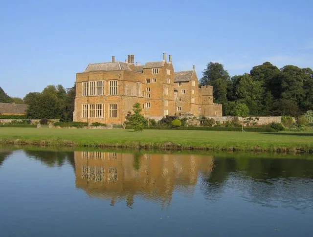
Broughton Castle — medieval manor house in Oxfordshire, England, UK.
More towns in this region
 Flagship📷 3
Towns & cities · West Midlands
Adderbury
Adderbury — village and civil parish in Cherwell district, Oxfordshire, England.
 Flagship📷 3
Towns & cities · West Midlands
Admington
Admington — village in Warwickshire, England, UK.
 Flagship📷 3
Towns & cities · West Midlands
Aldington
Aldington — village in Worcestershire, United Kingdom.
 Flagship📷 5
Towns & cities · West Midlands
Anstey
Anstey — large village in Leicestershire, England.
Frequently asked questions
- Where is Tadmarton?
- Tadmarton is in Oxfordshire, the West Midlands, United Kingdom (postcode OX15), in the parish of Tadmarton.
- Is Tadmarton a protected site?
- Yes — Tadmarton is part of the Cotswolds National Landscape (AONB).
- Is Tadmarton free to visit?
- Yes, Tadmarton is free to enter.
- How do I get to Tadmarton?
- The nearest railway station is Banbury, about 7.3 km away. Drivers can navigate to postcode OX15.