Reservoirs & lochs · East Midlands
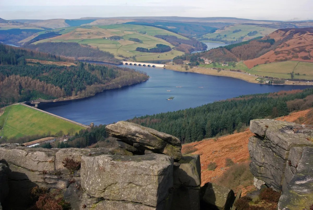
Strines Reservoir
Strines Reservoir — reservoir in South Yorkshire, England, UK.

Wikimedia Commons contributors — see linked file page for photographer and licence licence
Plan your visit
- Typical visit
- 1 h–2.5 h
- Nearest railway station
- Bamford · 8.2 km
- Free entry
- Dog-friendly
About
Strines Reservoir is a reservoir in the United Kingdom. Managed by Sheffield Corporation Water Works. Wikidata describes it as: "reservoir in South Yorkshire, England, UK". Coordinates: 53.4099°, -1.6557°.
Photo gallery
Protected designations
- Site of Special Scientific Interest: Dark Peak SSSI
- Site of Special Scientific Interest: Eastern Peak District Moors SSSI
Designations sourced from Natural England open data under OGL v3.
From the Wikipedia article
Strines Reservoir is a water storage reservoir situated at 53.4099°N 1.6557°W / 53.4099; -1.6557 (Strines_Reservoir), 8 miles (13 km) west of the centre of Sheffield in South Yorkshire, England.
Excerpt from Wikipedia under CC BY-SA 4.0. See the source article linked in Sources below.
Background
Architecture
The reservoir was constructed in 1869 after the Sheffield Waterworks Company made the decision in the late 1850s to build four reservoirs in Bradfield Dale to impound water from the surrounding moorland to provide for the growing town of Sheffield. Sheffield had previously received its water supply from the Crookesmoor dams close to the town centre but by the mid-19th century these were becoming inadequate. In addition to Strines, three other reservoirs were built: Damflask, Agden and Dale Dike. Strines was meant to be the final of the four reservoirs constructed; however, Dale Dike was not completed until 1875, having to be rebuilt after the failure of its dam wall caused the Great…
Description
The reservoir's main source of water comes off the Derwent Moors, 2 km to the west with the Strines Dike and Foulstone Dike rising at a height of around 500 metres above sea level and converging before flowing down to the reservoir which stands at a height of 250 metres. There are several smaller tributaries to the reservoir that flow off Ughill Moors to the south. There is only one habitation in the immediate vicinity of the reservoir, Brogging House, a dwelling which pre-dates the reservoir by some time, being recorded as being leased by George Woodhead in 1715 and probably significantly older than that. The house stands at the north end of the dam wall and at one time served as the…
Visiting
Access to the reservoir for walkers is quite good, with a bridleway approaching from the minor public road to the north known as Mortimer Road. From the south walkers may gain access by using part of the Sheffield Country Walk which approaches from Sugworth Road. It is also possible to walk up Bradfield Dale from Low Bradfield using various footpaths which also pass by Dale Dike Reservoir.
Sourced from Wikipedia under CC BY-SA 4.0.
- Coordinates
- 53.4099, -1.6557
- District
- Sheffield
- Parish
- Bradfield
- Postcode
- S6 6JE
- Parliamentary constituency
- Sheffield Hallam
- Nearest railway station
- Bamford — 8.2 km
Sources
- wikidata: Q7355832 (CC0)
- wikipedia: Strines Reservoir (CC BY-SA 4.0)
- commons: Strines Reservoir.jpg (CC BY-SA 4.0)
Other places nearby
Loading nearby places…
Nearby
 📷 3
📷 3Memorials & monuments · East Midlands
Sugworth Tower
Sugworth Tower — Grade II listed building-listed memorial in england-east-midlands, United Kingdom.
 📷 4
📷 4Historic houses · East Midlands
Sugworth Hall
Sugworth Hall — a Grade II*-listed historic house in england-east-midlands, United Kingdom.
 📷 3
📷 3Historic houses · East Midlands
Hallfield House
Hallfield House — house in Bradfield, Sheffield, England, UK.
 📷 3
📷 3Reservoirs & lochs · East Midlands
Dale Dike Reservoir
Dale Dike Reservoir — reservoir in South Yorkshire, England, UK.
 📷 3
📷 3Historic bridges · East Midlands
Byewash Bridge at Dale Dike Reservoir
Byewash Bridge at Dale Dike Reservoir — Grade II listed building-listed bridge in england-east-midlands, United Kingdom.
 📷 3
📷 3Historic bridges · East Midlands
Byewash Bridge
Byewash Bridge is a historic bridge in the United Kingdom.
More places run by Sheffield Corporation Water Works
📷 3Reservoirs & lochs · East Midlands
Dale Dike Reservoir
Dale Dike Reservoir — reservoir in South Yorkshire, England, UK.
 📷 5
📷 5Reservoirs & lochs · East Midlands
Damflask Reservoir
Damflask Reservoir — lake in the United Kingdom.
 📷 5
📷 5Reservoirs & lochs · East Midlands
Langsett Reservoir
Langsett Reservoir — reservoir in South Yorkshire, England, UK.
More places in this region
 Flagship📷 5
Reservoirs & lochs · East Midlands
Ladybower Reservoir
Ladybower Reservoir — reservoir in Derbyshire, England.
 📷 3
📷 3Reservoirs & lochs · East Midlands
Toddbrook Reservoir
Toddbrook Reservoir — reservoir in Derbyshire, England, UK.
 📷 3
📷 3Reservoirs & lochs · East Midlands
Agden Reservoir
Agden Reservoir — reservoir in South Yorkshire, England, UK.
 📷 5
📷 5Reservoirs & lochs · East Midlands
Arnfield Reservoir
Arnfield Reservoir — reservoir in Derbyshire, England, UK.
Frequently asked questions
- Where is Strines Reservoir?
- Strines Reservoir is in the East Midlands, United Kingdom (postcode S6 6JE), in the parish of Bradfield.
- Who runs Strines Reservoir?
- Strines Reservoir is operated by Sheffield Corporation Water Works.
- Is Strines Reservoir a protected site?
- Yes — Strines Reservoir is part of the Dark Peak SSSI Site of Special Scientific Interest and the Eastern Peak District Moors SSSI Site of Special Scientific Interest.
- How do I get to Strines Reservoir?
- Drivers can navigate to postcode S6 6JE. It sits within the Sheffield Hallam parliamentary constituency.