Historic churches · East Midlands
Stenigot
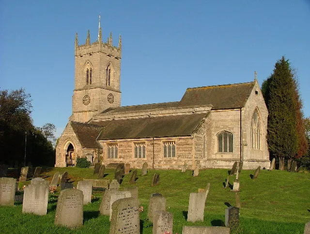
Stenigot is a village in the East Lindsey district of Lincolnshire, England. It is in the Lincolnshire Wolds, a designated Area of Outstanding Natural Beauty, about 6 miles (9.7 km) south-west from th

Julian P Guffogg — CC BY-SA 2.0 via Wikimedia Commons licence
Plan your visit
- Typical visit
- 30 min–1 h
- Free entry
About
Stenigot is a village in the East Lindsey district of Lincolnshire, England. It is in the Lincolnshire Wolds, a designated Area of Outstanding Natural Beauty, about 6 miles (9.7 km) south-west from the town of Louth, and 1 mile (1.6 km) south-east from the village of Donington on Bain. It includes the hamlet of Cold Harbour. The population is included in the civil parish of Asterby. The distinctive name 'Stenigot' is first attested in the Domesday Book of 1086, where it appears as Stangehou. This is thought to be a variant of the Old English Stāninga-hōh, meaning 'the spur of a hill' (hōh) of 'the people at a stone' (Stāninga). The parish church is dedicated to Saint Nicholas and is a Grade II listed building dating from 1892. Built of red brick and limestone, with a 15th-century octagonal font. There is a monument to Sir John Guevara, died 1607, of white, grey and orange streaked alabaster and a black marble inscription plaque to Francis Velles de Guevara, died 1592. The village is probably best known for RAF Stenigot, a Chain Home radar station during the Second World War and later as a NATO ACE High station, with four tropospheric scatter parabolic dishes, three of which now removed for their scrap value.
Photo gallery
From the Wikipedia article
Stenigot is a village in the East Lindsey district of Lincolnshire, England. It is in the Lincolnshire Wolds, a designated Area of Outstanding Natural Beauty, about 6 miles (9.7 km) south-west from the town of Louth, and 1 mile (1.6 km) south-east from the village of Donington on Bain. It includes the hamlet of Cold Harbour. The population is included in the civil parish of Asterby. The distinctive name 'Stenigot' is first attested in the Domesday Book of 1086, where it appears as Stangehou. This is thought to be a variant of the Old English Stāninga-hōh, meaning 'the spur of a hill' (hōh) of 'the people at a stone' (Stāninga). The parish church is dedicated to Saint Nicholas and is a Grade II listed building dating from 1892. Built of red brick and limestone, with a 15th-century octagonal font. There is a monument to Sir John Guevara, died 1607, of white, grey and orange streaked alabaster and a black marble inscription plaque to Francis Velles de Guevara, died 1592. The village is probably best known for RAF Stenigot, a Chain Home radar station during the Second World War and later as a NATO ACE High station, with four tropospheric scatter parabolic dishes, three of which now removed for their scrap value.
Excerpt from Wikipedia under CC BY-SA 4.0. See the source article linked in Sources below.
- Coordinates
- 53.3099, -0.1210
- County
- Lincolnshire
- District
- East Lindsey
- Parish
- Stenigot
- Postcode
- LN11 9SH
- Parliamentary constituency
- Louth and Horncastle
Sources
- wikipedia: Stenigot (CC BY-SA 4.0)
Other places nearby
Loading nearby places…
Nearby
 📷 3
📷 3Towns & cities · East Midlands
Goulceby
Goulceby — village and civil parish in East Lindsey, Lincolnshire, England.
 📷 3
📷 3Towns & cities · East Midlands
Asterby
Asterby — village in Lincolnshire, England.
 📷 4
📷 4Towns & cities · East Midlands
Donington on Bain
Donington on Bain — village and civil parish in Lincolnshire, UK.
 📷 3
📷 3Archaeological sites · East Midlands
Ranby Hoe
Ranby Hoe — a archaeological in england-east-midlands, United Kingdom.
 📷 3
📷 3Historic houses · East Midlands
Cawkwell House
Cawkwell House — house in Scamblesby, East Lindsey, Lincolnshire, England, UK.
 📷 5
📷 5Historic churches · East Midlands
Scamblesby
Scamblesby — a church in england-east-midlands, United Kingdom.
More places in this region
 📷 3
📷 3Historic churches · East Midlands
Addison Street Congregational Church
Addison Street Congregational Church — church in United Kingdom.
 📷 3
📷 3Historic churches · East Midlands
Albion Congregational Church
Albion Congregational Church — church building in Nottingham, Nottinghamshire, England, UK.
 📷 3
📷 3Historic churches · East Midlands
All Hallows' Church, Ordsall
All Hallows' Church, Ordsall — Grade I listed church in Bassetlaw, Nottinghamshire, England, UK.
 📷 3
📷 3Historic churches · East Midlands
All Saints Church
All Saints Church — church in Barrowby, Lincolnshire, England, UK.
Frequently asked questions
- Where is Stenigot?
- Stenigot is in Lincolnshire, the East Midlands, United Kingdom (postcode LN11 9SH), in the parish of Stenigot.
- Is Stenigot free to visit?
- Yes, Stenigot is free to enter.
- How do I get to Stenigot?
- Drivers can navigate to postcode LN11 9SH. It sits within the Louth and Horncastle parliamentary constituency.