Historic churches · North West England
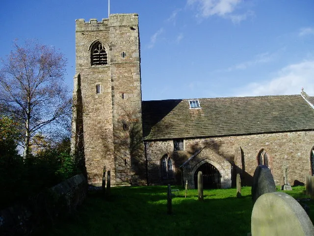
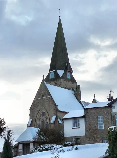
St Leonard's Church, Walton-le-Dale
St Leonard's Church, Walton-le-Dale — church in South Ribble, Lancashire, England, UK.

Wikimedia Commons contributors — see linked file page for photographer and licence licence
Plan your visit
- Typical visit
- 30 min–1 h
- Nearest railway station
- Bamber Bridge · 2.3 km
- Free entry
About
St Leonard's Church, Walton-le-Dale is a historic church in the United Kingdom. Built in the English Gothic architecture style. Heritage designation: Grade II* listed building. Affiliated with Anglicanism. Wikidata describes it as: "church in South Ribble, Lancashire, England, UK". Coordinates: 53.7476°, -2.6665°.
Photo gallery
Heritage listing
St Leonard's Church is an Anglican church in Walton-le-Dale, Lancashire, England. It is an active parish church in the Diocese of Blackburn and the archdeaconry of Blackburn. In 1950 it was designated as a Grade II* listed building. Parts of the church date from the 16th century and the nave and transepts were rebuilt in the early 20th century.
From the Historic England List Entry under OGL v3.
From the Wikipedia article
St Leonard's Church is an Anglican church in Walton-le-Dale, Lancashire, England. It is an active parish church in the Diocese of Blackburn and the archdeaconry of Blackburn. In 1950 it was designated as a Grade II* listed building. Parts of the church date from the 16th century and the nave and transepts were rebuilt in the early 20th century.
Excerpt from Wikipedia under CC BY-SA 4.0. See the source article linked in Sources below.
Background
History
Parts of St Leonard's—the chancel and tower—date from the 16th century. The nave and transepts were completely rebuilt in 1902–1906 by John Pollard Seddon; St Leonard's was his final project. The new nave and transepts were built on almost the same plan as the previous ones because of the close proximity of graves surrounding the church. St Leonard's was designated as a Grade II* listed building on 24 March 1950. The Grade II* designation is the second highest of the three grades. An active parish church in the Church of England, St Leonard's is part of the diocese of Blackburn, which is in the Province of York. It is in the archdeaconry of Blackburn and the Deanery of Leyland. The church…
Architecture
Internally, the nave is 60 ft by 42 ft. The walls are faced with sandstone from Runcorn. The size of the double transepts gives the impression of the church being longer internally north–south than it is east–west. There is a gallery on the west side, accessed from a stone staircase in the porch. The roof has an open, hammerbeam structure. The chancel has a tie beam roof with exposed kingpost trusses. In the chancel, there is a plaster panel from 1634 with the coat of arms of the Assheton family of Cuerdale Hall and a brass memorial from 1770 to the wife of Ralph Assheton. Stained glass in the church includes the east window from 1850 by Birmingham firm Hardman & Co. and later work by…
Sourced from Wikipedia under CC BY-SA 4.0.
- Coordinates
- 53.7476, -2.6665
- County
- Lancashire
- District
- South Ribble
- Parish
- South Ribble, unparished area
- Postcode
- PR5 4HH
- Parliamentary constituency
- Ribble Valley
- Nearest railway station
- Bamber Bridge — 2.3 km
Sources
- wikidata: Q7593991 (CC0)
- wikipedia: St Leonard's Church, Walton-le-Dale (CC BY-SA 4.0)
- commons: St. Leonard's Church - geograph.org.uk - 2088009.jpg (CC BY-SA 4.0)
Other places nearby
Loading nearby places…
Nearby
 📷 3
📷 3Memorials & monuments · North West England
Walton-le-Dale War Memorial
Walton-le-Dale War Memorial — Grade II listed building-listed memorial in england-north-west, United Kingdom.
 📷 3
📷 3Theatres · North West England
Vue Preston
Vue Preston in England North West, United Kingdom.
Cinemas · North West England
Vue
Vue — a cinema in england north west.
 📷 3
📷 3Archaeological sites · North West England
Roman settlement and industrial area at Winery Lane
Roman settlement and industrial area at Winery Lane — archaeological site in South Ribble, Lancashire, England, UK.
.jpg?width=1200) 📷 3
📷 3Historic houses · North West England
Osbaldeston House
Osbaldeston House — Grade II* listed house in Walton-le-Dale, Lancashire, England, UK.
 📷 5
📷 5Museums · North West England
River Darwen
The River Darwen runs through Darwen and Blackburn in Lancashire, England, eventually joining the River Ribble at Walton le Dale south of Preston on its way to the Ribble Estuary.
More places in this region
 📷 3
📷 3Historic churches · North West England
All Hallows Church, Great Mitton
All Hallows Church, Great Mitton — church in the village of Great Mitton, Lancashire, England, UK.
 📷 3
📷 3Historic churches · North West England
All Saints Church, Barnacre
All Saints Church, Barnacre — grade II listed church in Barnacre-with-Bonds, Wyre, Lancashire, England, UK.
 📷 3
📷 3Historic churches · North West England
All Saints Church, Becconsall
All Saints Church, Becconsall — church in United Kingdom.
 📷 3
📷 3Historic churches · North West England
All Saints Church, Burton in Lonsdale
All Saints Church, Burton in Lonsdale — church in Burton in Lonsdale, North Yorkshire, England, UK.
Frequently asked questions
- Where is St Leonard's Church, Walton-le-Dale?
- St Leonard's Church, Walton-le-Dale is in Lancashire, North-West England, United Kingdom (postcode PR5 4HH), in the parish of South Ribble, unparished area.
- Is St Leonard's Church, Walton-le-Dale a listed building?
- St Leonard's Church, Walton-le-Dale is officially recognised as Grade II* listed building listed.
- Is St Leonard's Church, Walton-le-Dale free to visit?
- Yes, St Leonard's Church, Walton-le-Dale is free to enter.
- How do I get to St Leonard's Church, Walton-le-Dale?
- The nearest railway station is Bamber Bridge, about 2.3 km away. Drivers can navigate to postcode PR5 4HH.