Mountains & hills · Northern Ireland
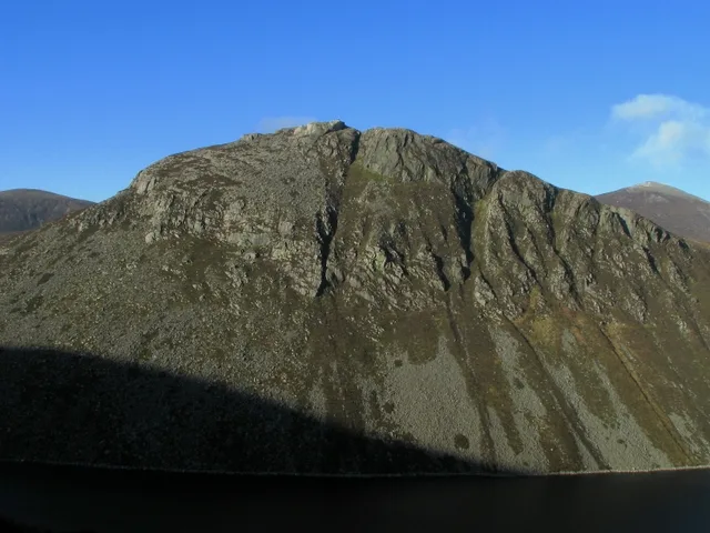
Slieve Commedagh
Also known as: Sliabh Coimhéideach
Slieve Commedagh — Named summit at 767 m.

Wikimedia Commons contributors — see linked file page for photographer and licence licence
Plan your visit
- Typical visit
- 3 h–8 h
- Best time of year
- Late spring – early autumn (May–Oct)
- Free entry
- Dog-friendly
About
Slieve Commedagh is a named summit in the United Kingdom. Also known as: Sliabh Coimhéideach. Wikidata describes it as: "Named summit at 767 m.". Coordinates: 54.1889°, -5.9386°.
Photo gallery
From the Wikipedia article
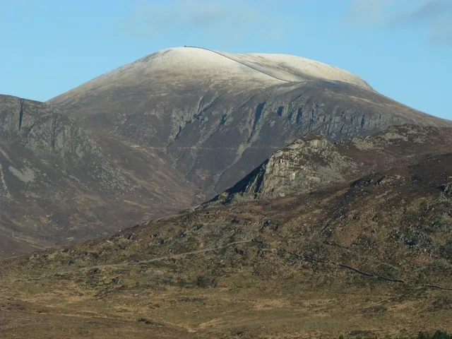
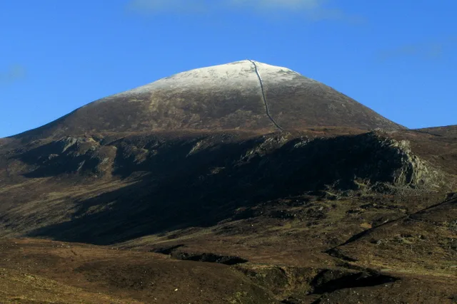
Slieve Commedagh (from Irish Sliabh Coimhéideach, meaning 'the guarding/watching mountain') is a mountain with a height of 767 m (2,516 ft) in County Down, Northern Ireland. After Slieve Donard, it is the second-highest of the Mourne Mountains and the second-highest mountain in Northern Ireland. Slieve Commedagh is northwest of Slieve Donard, and the two are linked by a col. Further west of Slieve Commedagh is the lower summit of Slieve Corragh. The Mourne Wall passes east–west over the mountaintop, and there is a small tower at the summit. There are also the remains of an ancient burial cairn on the mountaintop. Slieve Commedagh overlooks the Glen River to the east, and the Pot of Legawherry to the west. On its southern side are a group of granite tors known as 'the Castles'. This overlooks the Brandy Pad, a track used in the 18th century to smuggle commodities such as brandy and tobacco, mainly from Britain. The Slieve Commedagh massif also includes the lesser summits of Shan Slieve, Slievenamaddy and Slievenabrock (to the north).
Excerpt from Wikipedia under CC BY-SA 4.0. See the source article linked in Sources below.
- Coordinates
- 54.1889, -5.9386
- Address
- County Down, Northern Ireland
Sources
- osm: n332372550 (ODbL)
- wikipedia: Slieve Commedagh (CC BY-SA 4.0)
- commons: Slieve Commedagh - geograph - 1136954.jpg (CC BY-SA 4.0)
Other places nearby
Loading nearby places…
Nearby
 📷 4
📷 4Natural landmarks · Northern Ireland
Slieve Commedagh
Slieve Commedagh — mountain in the United Kingdom.
 📷 3
📷 3Mountains & hills · Northern Ireland
Slieve Donard
Slieve Donard — Named summit at 849 m.
 📷 3
📷 3Natural landmarks · Northern Ireland
Slieve Donard
Slieve Donard — mountain in County Down, Northern Ireland, UK.
 📷 4
📷 4Natural landmarks · Northern Ireland
Glen River, County Down
Glen River, County Down in Northern Ireland, United Kingdom.
Climbing & bouldering crags · Northern Ireland
Annalong Buttress
Annalong Buttress — a climbing crag in northern ireland.
 📷 5
📷 5Natural landmarks · Northern Ireland
Bryansford
Bryansford in Northern Ireland, United Kingdom.
More mountains in this region
 📷 5
📷 5Mountains & hills · Northern Ireland
Belfast Lough
Belfast Lough — intertidal inlet in Northern Ireland.
 📷 5
📷 5Mountains & hills · Northern Ireland
Belmore Mountain
Belmore Mountain — Named summit at 398 m.
 📷 4
📷 4Mountains & hills · Northern Ireland
Ben Crom
Ben Crom — Named summit at 526 m.
 📷 3
📷 3Mountains & hills · Northern Ireland
Benbradagh
Benbradagh — Named summit at 465 m.
Frequently asked questions
- Where is Slieve Commedagh?
- Slieve Commedagh is in Northern Ireland, in the United Kingdom — coordinates 54.1889°, -5.9386°.
- Is Slieve Commedagh free to visit?
- Yes — admission to Slieve Commedagh is free.