Towns & cities · South East England
Shermanbury
Shermanbury — village in West Sussex, England, UK.

Wikimedia Commons contributors — see linked file page for photographer and licence licence
Plan your visit
- Typical visit
- 3 h–6 h
- Free entry
- Family-friendly
- Dog-friendly
About
Shermanbury is a town, city, village or settlement in the United Kingdom. It covers approximately 8 km². Recent population estimates put it at around 454 people. Address: RH13. Wikidata describes it as: "village in West Sussex, England, UK". Coordinates: 50.9598°, -0.2856°.
Photo gallery
Protected designations
- Area of Outstanding Natural Beauty: High Weald
Designations sourced from Natural England open data under OGL v3.
From the Wikipedia article
Shermanbury is a village and civil parish in the Horsham District of West Sussex, England. It lies on the A281 road approximately 2 miles (3 km) north of Henfield. The present day village consists mainly of a ribbon development of bungalows on the east side of the A281, while the ancient parish church is to the east by Shermanbury Place. Between these is Ewhurst Manor, a 16th-century house on an old moated site with a 14th-century stone gatehouse and nearby artificial lake and farmstead. The eastern River Adur flows through Shermanbury, where it is met by the Cowfold Stream. The Normal Tidal Limit is at the footbridge near the church although a weir further downstream means only the highest tides reach this far. Boats could reach Mock Bridge (where the A281 crosses the river) until the early 1800s. The parish has a land area of 775 hectares (1,915 acres). In the 2001 census 454 people lived in 182 households of whom 253 were economically active. The population at the 2011 Census was 542.
Excerpt from Wikipedia under CC BY-SA 4.0. See the source article linked in Sources below.
Background
History
In the Domesday Book, based on a survey completed in 1086, the manor of Shermanbury, then called Salmonesberie, is held by Ralph from William de Braose, having been formerly held by Azor from King Harold. There are two ploughs, one belonging to the lord and one shared by one villager and three smallholders. There is a small church and four slaves. There are three other manors in Shermanbury parish, Woolfly, also held by Ralph, and Morley and Sakeham held by William son of Ranulph. The parishes of Shermanbury and Cowfold comprised the Saxon hundred of Hamfelt, and was on the eastern boundary of the Norman Rape of Bramber. Shermanbury's Saxon name indicates its past function: the burh or…
Description
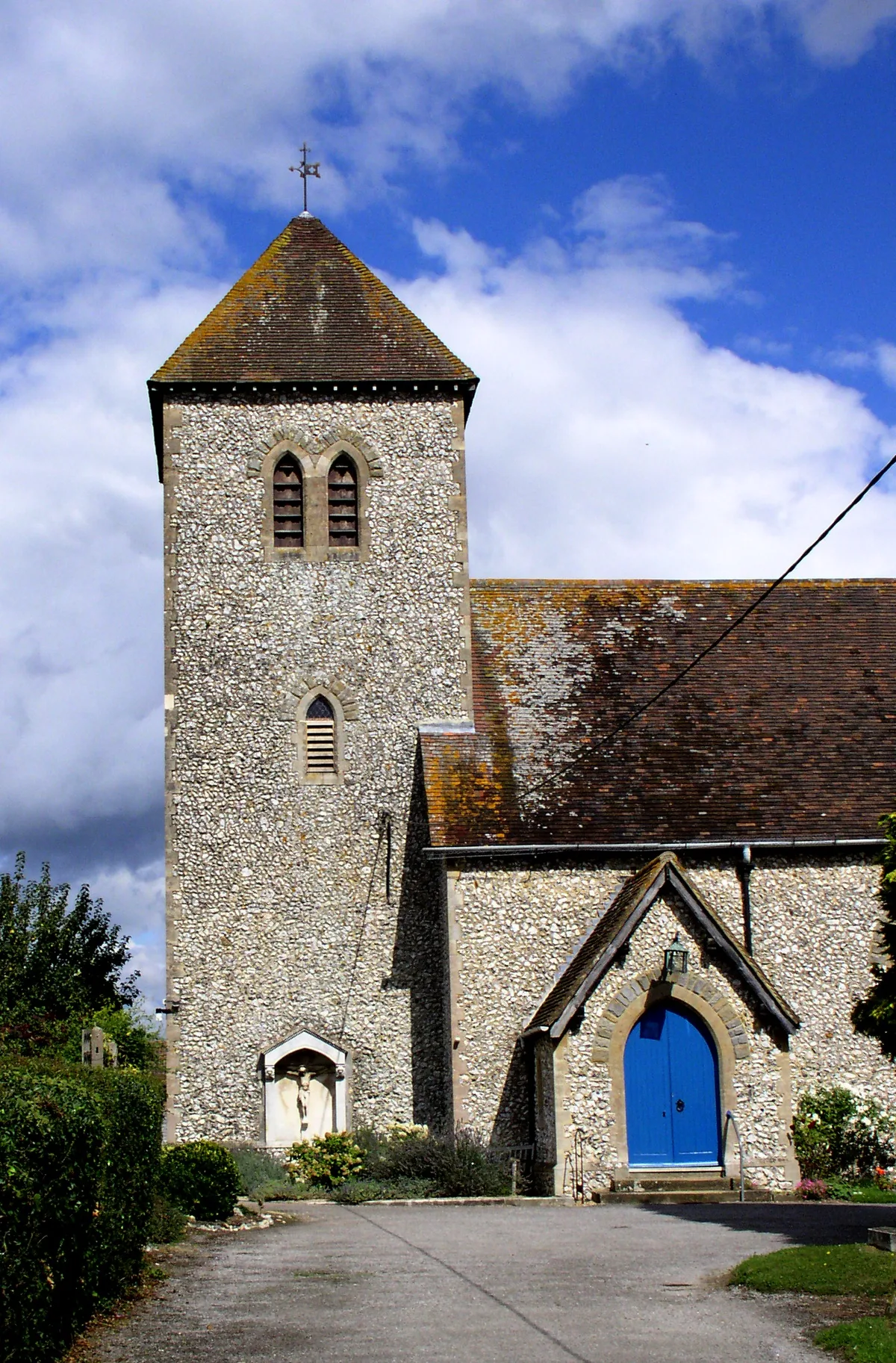
The Anglican church of St. Giles () is well away from the modern roads, approached along a tree-lined bridleway leading to Shermanbury Place, east of the Brighton road. A small church is mentioned in the Domesday Book, but the present structure is of 14th-century origin. The roof is made from Horsham stone slates with a weatherboarded bell tower at the west end, containing two bells. The door and stone roofed porch are at the west end. Inside 18th century pews have the names of farm houses to which they were allocated painted on the backs: Perrymans, Sakeham, Vadgers, Pooks, and so on. It is now locked, but the church warden will show people round on request. Its wildflower-rich graveyard…
Sourced from Wikipedia under CC BY-SA 4.0.
- Coordinates
- 50.9598, -0.2856
- County
- West Sussex
- District
- Horsham
- Parish
- Shermanbury
- Postcode
- RH13
- Parliamentary constituency
- Horsham
- Population
- 454
- Official site
- www.westsussex.gov.uk
Sources
- wikidata: Q1916040 (CC0)
- wikipedia: Shermanbury (CC BY-SA 4.0)
- commons: Shermanbury church.JPG (CC BY-SA 4.0)
Other places nearby
Loading nearby places…
Nearby
 📷 5
📷 5Manor houses · South East England
Ewhurst Manor
Ewhurst Manor — Grade II listed building-listed manor in england-south-east, United Kingdom.
 📷 5
📷 5Historic churches · South East England
The Parish Church of St Giles, Shermanbury
The Parish Church of St Giles, Shermanbury — Grade II* listed building-listed church in england-south-east, United Kingdom.
 📷 5
📷 5Breweries · South East England
Dark Star Brewing Co.
Dark Star Brewing Co. — brewery in Partridge Green.
 📷 5
📷 5Historic churches · South East England
St Michael and All Angels Church, Partridge Green
St Michael and All Angels Church, Partridge Green — church in United Kingdom.
 📷 5
📷 5Windmills · South East England
Jolesfield Windmill (disused)
Jolesfield Windmill (disused) is a windmill in the United Kingdom.
 📷 5
📷 5Memorials & monuments · South East England
West Grinstead, Dial Post, Littleworth and Partridge Green War Memorial
West Grinstead, Dial Post, Littleworth and Partridge Green War Memorial — Grade II listed building-listed memorial in england-south-east, United Kingdom.
More towns in this region
 Flagship📷 10
Towns & cities · South East England
Aldermaston
Aldermaston — village and civil parish in West Berkshire in England, UK.
 Flagship📷 10
Towns & cities · South East England
Aldingbourne
Aldingbourne — village and civil parish in Arun, West Sussex, UK.
 Flagship📷 10
Towns & cities · South East England
Aldington
Aldington — village and civil parish in the Ashford District of Kent, England.
 Flagship📷 10
Towns & cities · South East England
Aldworth
Aldworth — village and civil parish in the English county of Berkshire.
Frequently asked questions
- Where is Shermanbury?
- Shermanbury is in West Sussex, South-East England, United Kingdom (postcode RH13), in the parish of Shermanbury.
- Is Shermanbury a protected site?
- Yes — Shermanbury is part of the High Weald National Landscape (AONB).
- Is Shermanbury free to visit?
- Yes, Shermanbury is free to enter.
- How do I get to Shermanbury?
- Drivers can navigate to postcode RH13. It sits within the Horsham parliamentary constituency.