Natural landmarks · Scottish Highlands
Sgùrr na Banachdaich
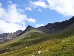
Sgùrr na Banachdaich — 965m high mountain in Highland, Scotland, UK.

Wikimedia Commons contributors — see linked file page for photographer and licence licence
Plan your visit
- Typical visit
- 1 h–2 h
- Free entry
- Dog-friendly
About
Sgùrr na Banachdaich is a named natural landmark in the United Kingdom. Wikidata describes it as: "965m high mountain in Highland, Scotland, UK". Coordinates: 57.2210°, -6.2416°.
Photo gallery
From the Wikipedia article
Sgùrr na Banachdaich (Gaelic for "smallpox peak"), also spelt Sgurr na Banachdich in English, is a peak in the Cuillin mountains on the Isle of Skye, Scotland. It reaches a height of 965 metres (3,166 ft), making it a Munro; standing at the western edge of the Cuillin ridge, it is the most westerly of the Munros. The ascent from Glen Brittle via Coire nan Eich is one of the easiest routes to a major summit in the Cuillin, as the use of hands is not strictly required if following the main route, though it is a rough and sometimes steep walk and routefinding can be difficult if descending this route in poor visibility. All other approaches require scrambling; the other main route from Glen Brittle is via the spur of Sgùrr nan Gobhar, which involves ascending very steep scree before traversing its narrow ridge. The remaining approaches are via the main Cuillin ridge from neighbouring peaks or passes, with the South Ridge providing attractive scrambling over several subsidiary peaks. Its name is said to refer to the marked, or pitted, appearance of the rocks in Coire na Banachdaich, the corrie below the peak.
Excerpt from Wikipedia under CC BY-SA 4.0. See the source article linked in Sources below.
- Coordinates
- 57.2210, -6.2416
- Address
- Skye, Scotland
Sources
- wikidata: Q3775711 (CC0)
- wikipedia: Sgùrr na Banachdaich (CC BY-SA 4.0)
- commons: Sgurr banachdich.jpg (CC BY-SA 4.0)
Other places nearby
Loading nearby places…
Nearby
 📷 3
📷 3Mountains & hills · Scottish Highlands
Sgùrr na Banachdaich
Sgùrr na Banachdaich — Named summit at 965 m.
 📷 3
📷 3Mountains & hills · Scottish Highlands
Sgùrr a' Ghreadaidh
Sgùrr a' Ghreadaidh — Named summit at 973 m.
 📷 3
📷 3Natural landmarks · Scottish Highlands
Sgùrr a' Ghreadaidh
Sgùrr a' Ghreadaidh — 973m high mountain in Highland, Scotland, UK.
 📷 3
📷 3Mountains & hills · Scottish Highlands
Sgùrr Dearg
Sgùrr Dearg — Named summit at 977 m.
 📷 3
📷 3Mountains & hills · Scottish Highlands
Inaccessible Pinnacle
Inaccessible Pinnacle — a mountain in scotland-highlands, United Kingdom, 986 m.
 📷 3
📷 3Mountains & hills · Scottish Highlands
The Inaccessible Pinnacle
The Inaccessible Pinnacle — Named summit at 986 m.
More natural landmarks in this region
 Flagship📷 3
Natural landmarks · Scottish Highlands
Dunalastair Water
Dunalastair Water — lake in Perth and Kinross, Scotland, UK, on the River Tummel.
 Flagship📷 3
Natural landmarks · Scottish Highlands
Loch Arkaig
Loch Arkaig — lake in Highland, Scotland, UK, outflows east to River Arkaig.
 Flagship📷 3
Natural landmarks · Scottish Highlands
Loch Assynt
Loch Assynt — lake in Highland, Scotland, UK, outflows to the River Inver and Loch na Garbh Uidhe.
 Flagship📷 3
Natural landmarks · Scottish Highlands
Loch Awe
Loch Awe — lake in Argyll and Bute, Scotland, UK, outflows to the River Awe.
Frequently asked questions
- Where is Sgùrr na Banachdaich?
- Sgùrr na Banachdaich is in Scottish Highlands, in the United Kingdom — coordinates 57.2210°, -6.2416°.
- Is Sgùrr na Banachdaich free to visit?
- Yes — admission to Sgùrr na Banachdaich is free.