Mountains & hills · Scottish Highlands
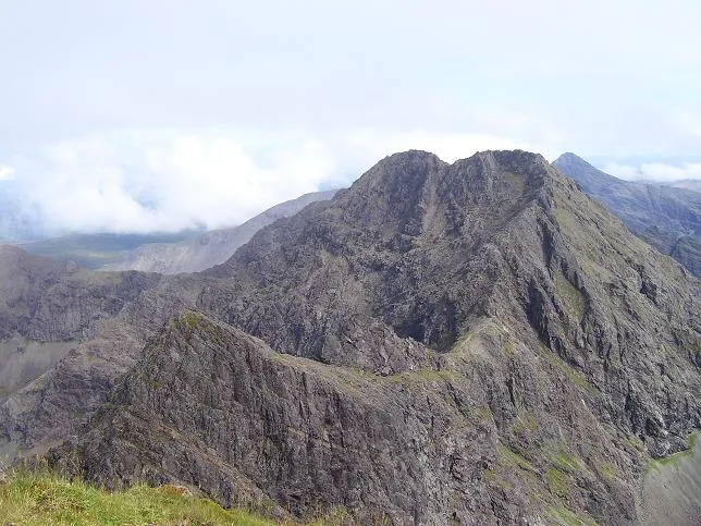
Sgùrr a' Ghreadaidh
Sgùrr a' Ghreadaidh — Named summit at 973 m.

Wikimedia Commons contributors — see linked file page for photographer and licence licence
Plan your visit
- Typical visit
- 3 h–8 h
- Best time of year
- Late spring – early autumn (May–Oct)
- Free entry
- Dog-friendly
About
Sgùrr a' Ghreadaidh is a named summit in the United Kingdom. Wikidata describes it as: "Named summit at 973 m.". Coordinates: 57.2273°, -6.2344°.
Photo gallery
From the Wikipedia article
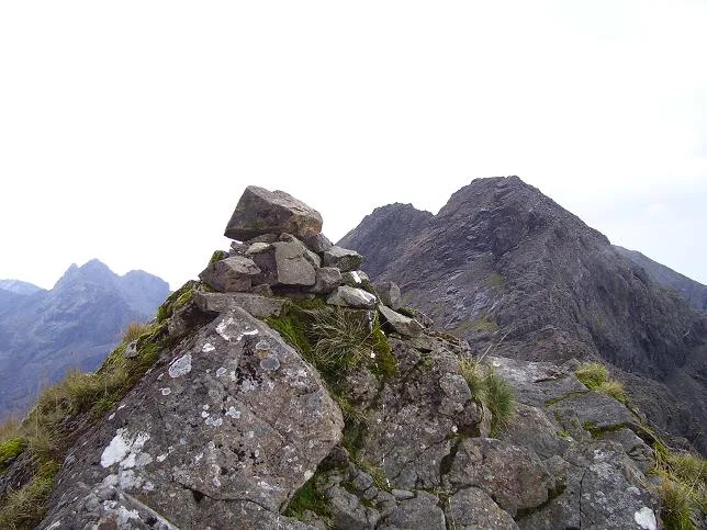
Sgùrr a' Ghreadaidh (Scottish Gaelic: Sgùrr a’ Ghreadhaich, "peak of torment") is the highest peak on the northern half of the Black Cuillin ridge on the Isle of Skye in Scotland. Like the rest of the range it is composed of gabbro, a rock that provides good grip for mountaineering. This is one of the harder main Black Cuillin peaks to ascend. The simplest route ascends via the col of An Dorus (the Door), most easily reached from Glen Brittle; however, the immediate exit from An Dorus is a Grade 3 scramble and there is sustained scrambling of a lower grade on the north ridge leading to the summit. The south ridge leading towards Sgùrr Thormaid is also Grade 3, with few opportunities to descend safely for some considerable distance. The mountain has two summits, separated by a knife-edged arete. At the time of the first ascent, John MacKenzie was aged just 14. He had earlier repeated the ascent of Sgùrr nan Gillean aged 10. Mackenzie became the first British mountain guide and perhaps the most prolific of the pioneers of mountaineering in the Cuillin.
Excerpt from Wikipedia under CC BY-SA 4.0. See the source article linked in Sources below.
- Coordinates
- 57.2273, -6.2344
- Address
- Skye, Scotland
- Official site
- www.walkhighlands.co.uk
Sources
- osm: n388371678 (ODbL)
- wikipedia: Sgùrr a' Ghreadaidh (CC BY-SA 4.0)
- commons: Sgurr ghreadaidh.jpg (CC BY-SA 4.0)
Other places nearby
Loading nearby places…
Nearby
 📷 3
📷 3Natural landmarks · Scottish Highlands
Sgùrr a' Ghreadaidh
Sgùrr a' Ghreadaidh — 973m high mountain in Highland, Scotland, UK.
 📷 3
📷 3Natural landmarks · Scottish Highlands
Sgùrr a' Mhadaidh
Sgùrr a' Mhadaidh — 918m high mountain in Highland, Scotland, UK.
 📷 3
📷 3Mountains & hills · Scottish Highlands
Sgùrr a' Mhadaidh
Sgùrr a' Mhadaidh — Named summit at 918 m.
 📷 3
📷 3Natural landmarks · Scottish Highlands
Sgùrr na Banachdaich
Sgùrr na Banachdaich — 965m high mountain in Highland, Scotland, UK.
 📷 3
📷 3Mountains & hills · Scottish Highlands
Sgùrr na Banachdaich
Sgùrr na Banachdaich — Named summit at 965 m.
 📷 3
📷 3Mountains & hills · Scottish Highlands
Sgùrr Thuilm
Sgùrr Thuilm — Named summit at 879 m.
More mountains in this region
 📷 3
📷 3Mountains & hills · Scottish Highlands
A' Bhuidheanach Bheag
A' Bhuidheanach Bheag — Named summit at 936 m.
 📷 3
📷 3Mountains & hills · Scottish Highlands
A' Chailleach
A' Chailleach — Named summit at 997 m.
 📷 3
📷 3Mountains & hills · Scottish Highlands
A' Chailleach
A' Chailleach — Named summit at 930 m.
 📷 3
📷 3Mountains & hills · Scottish Highlands
A' Chaoirnich
A' Chaoirnich — Named summit at 875 m.
Frequently asked questions
- Where is Sgùrr a' Ghreadaidh?
- Sgùrr a' Ghreadaidh is in Scottish Highlands, in the United Kingdom — coordinates 57.2273°, -6.2344°.
- Is Sgùrr a' Ghreadaidh free to visit?
- Yes — admission to Sgùrr a' Ghreadaidh is free.