Towns & cities · South East England
Semington
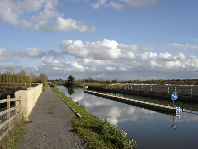
Semington — village and civil parish in Wiltshire, United Kingdom.

Wikimedia Commons contributors — see linked file page for photographer and licence licence
Plan your visit
- Typical visit
- 3 h–6 h
- Nearest railway station
- Melksham · 4.2 km
- Free entry
- Family-friendly
- Dog-friendly
About
Semington is a town, city, village or settlement in the United Kingdom. Recent population estimates put it at around 830 people. Address: BA14. Wikidata describes it as: "village and civil parish in Wiltshire, United Kingdom". Coordinates: 51.3430°, -2.1510°.
Photo gallery
Protected designations
- Area of Outstanding Natural Beauty: Cotswolds
Designations sourced from Natural England open data under OGL v3.
From the Wikipedia article
Semington is a village and civil parish in Wiltshire, England. The village is about 2 miles (3 km) south of Melksham and about 3 miles (5 km) northeast of Trowbridge. The parish includes the hamlets of Little Marsh and Littleton. The village has two locks on the Kennet and Avon Canal, known as the Semington Locks, and nearby is the start of the disused Wilts and Berks Canal.
Excerpt from Wikipedia under CC BY-SA 4.0. See the source article linked in Sources below.
Background
History
Anciently, Semington and Littleton were each tithings of Steeple Ashton parish (Semington village being about 2+1/4 mi north of Steeple Ashton village). In the late 19th century the civil parish of Semington was formed from the two tithings, and in 1894 the ancient parish of Whaddon was added to it. Whaddon was transferred to Hilperton in the late 20th century. The population of the parish was in the range 400 to 500 for many years, from the 1841 census to that of 1931. Numbers then gradually increased to reach 930 in 2011.
Sourced from Wikipedia under CC BY-SA 4.0.
- Coordinates
- 51.3430, -2.1510
- District
- Wiltshire
- Parish
- Semington
- Postcode
- BA14
- Parliamentary constituency
- Melksham and Devizes
- Population
- 830
- Nearest railway station
- Melksham — 4.2 km
- Official site
- www.semington-village.co.uk
Sources
- wikidata: Q512078 (CC0)
- wikipedia: Semington (CC BY-SA 4.0)
- commons: Semington.jpg (CC BY-SA 4.0)
Other places nearby
Loading nearby places…
Nearby
 📷 5
📷 5Memorials & monuments · South East England
Semington War Memorial
Semington War Memorial — Grade II listed building-listed memorial in england-south-east, United Kingdom.
 📷 5
📷 5Historic bridges · South East England
Semington Aqueduct
Semington Aqueduct is a historic bridge in the United Kingdom.
 📷 5
📷 5Canal locks · South East England
Semington Locks
Semington Locks — lock in Semington, Wiltshire, England, UK.
 📷 5
📷 5Aqueducts · South East England
New Semington Aqueduct
New Semington Aqueduct — bridge in United Kingdom.
 📷 5
📷 5Historic bridges · South East England
New Semington Aqueduct
New Semington Aqueduct is a historic bridge in the United Kingdom.
 📷 5
📷 5Historic bridges · South East England
Bridge Immediately North North West Of Whaddon Grove Farmhouse
Bridge Immediately North North West Of Whaddon Grove Farmhouse — Grade II listed building-listed bridge in england-south-east, United Kingdom.
More towns in this region
 Flagship📷 10
Towns & cities · South East England
Aldermaston
Aldermaston — village and civil parish in West Berkshire in England, UK.
 Flagship📷 10
Towns & cities · South East England
Aldingbourne
Aldingbourne — village and civil parish in Arun, West Sussex, UK.
 Flagship📷 10
Towns & cities · South East England
Aldington
Aldington — village and civil parish in the Ashford District of Kent, England.
 Flagship📷 10
Towns & cities · South East England
Aldworth
Aldworth — village and civil parish in the English county of Berkshire.
Frequently asked questions
- Where is Semington?
- Semington is in South-East England, United Kingdom (postcode BA14), in the parish of Semington.
- Is Semington a protected site?
- Yes — Semington is part of the Cotswolds National Landscape (AONB).
- Is Semington free to visit?
- Yes, Semington is free to enter.
- How do I get to Semington?
- The nearest railway station is Melksham, about 4.2 km away. Drivers can navigate to postcode BA14.