Historic bridges · South East England
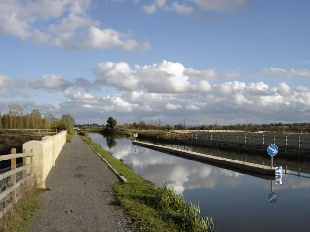
Semington Aqueduct
Semington Aqueduct is a historic bridge in the United Kingdom.

Wikimedia Commons contributors — see linked file page for photographer and licence licence
Plan your visit
- Typical visit
- 15 min–30 min
- Nearest railway station
- Melksham · 3.7 km
- Free entry
- Dog-friendly
About
Semington Aqueduct is a named historic bridge in the United Kingdom. Coordinates: 51.3475°, -2.1495°. This entry is part of The Great Britain Guide, a free, ad-free, open-data tourist directory.
Photo gallery
Protected designations
- Area of Outstanding Natural Beauty: Cotswolds
Designations sourced from Natural England open data under OGL v3.
From the Wikipedia article
Semington Aqueduct (grid reference ST896609) is an aqueduct at Semington, Wiltshire, England, UK. It carries the Kennet and Avon Canal over the Semington Brook.
Excerpt from Wikipedia under CC BY-SA 4.0. See the source article linked in Sources below.
Background
History
The Kennet and Avon Canal was the realisation of a plan to link the River Avon to the River Thames and hence Bristol to London, which had first been suggested in the late 1500s, during the reign of Queen Elizabeth I. The canal was surveyed by John Rennie and following a change of route, which resulted in the canal passing through Devizes and hence Semington, rather than Marlborough and Calne, an Act of Parliament was obtained in 1794 to authorise the plan and work began. The eastern section opened first, with the line from Newbury and the River Kennet to Hungerford opening in 1798, and from there to Great Bedwyn opening the following year. The western section through Semington was partially…
Architecture
The aqueduct consists of a single stilted segmental arch, mainly constructed of limestone ashlar masonry, although some repairs have been made with engineering bricks. On both sides of the structure there is a rectangular moulded panel, but no evidence that it ever carried an inscription. It has been a grade II listed structure since 1988.
Sourced from Wikipedia under CC BY-SA 4.0.
- Coordinates
- 51.3475, -2.1495
- District
- Wiltshire
- Parish
- Semington
- Postcode
- BA14 6NN
- Parliamentary constituency
- Melksham and Devizes
- Nearest railway station
- Melksham — 3.7 km
- Opening
- |rebuilt =
Sources
- osm: w655381572 (ODbL)
- wikipedia: Semington Aqueduct (CC BY-SA 4.0)
- commons: Semington Aqueduct.jpg (CC BY-SA 4.0)
Other places nearby
Loading nearby places…
Nearby
 📷 5
📷 5Canal locks · South East England
Semington Locks
Semington Locks — lock in Semington, Wiltshire, England, UK.
 📷 5
📷 5Memorials & monuments · South East England
Semington War Memorial
Semington War Memorial — Grade II listed building-listed memorial in england-south-east, United Kingdom.
 📷 5
📷 5Towns & cities · South East England
Semington
Semington — village and civil parish in Wiltshire, United Kingdom.
 📷 5
📷 5Aqueducts · South East England
New Semington Aqueduct
New Semington Aqueduct — bridge in United Kingdom.
 📷 5
📷 5Historic bridges · South East England
New Semington Aqueduct
New Semington Aqueduct is a historic bridge in the United Kingdom.
 📷 5
📷 5Historic bridges · South East England
Bridge Immediately North North West Of Whaddon Grove Farmhouse
Bridge Immediately North North West Of Whaddon Grove Farmhouse — Grade II listed building-listed bridge in england-south-east, United Kingdom.
More bridges in this region
 📷 5
📷 5Historic bridges · South East England
Arundel Bridge
Arundel Bridge is a historic bridge in the United Kingdom.
 📷 5
📷 5Historic bridges · South East England
Ash Aqueduct
Ash Aqueduct is a historic bridge in the United Kingdom.
 📷 5
📷 5Historic bridges · South East England
Avoncliff Aqueduct
Avoncliff Aqueduct is a historic bridge in the United Kingdom.
📷 5Historic bridges · South East England
Avoncliff Aqueduct
Avoncliff Aqueduct is a historic bridge in the United Kingdom.
Frequently asked questions
- Where is Semington Aqueduct?
- Semington Aqueduct is in South-East England, United Kingdom (postcode BA14 6NN), in the parish of Semington.
- Is Semington Aqueduct a protected site?
- Yes — Semington Aqueduct is part of the Cotswolds National Landscape (AONB).
- Is Semington Aqueduct free to visit?
- Yes, Semington Aqueduct is free to enter.
- How do I get to Semington Aqueduct?
- The nearest railway station is Melksham, about 3.7 km away. Drivers can navigate to postcode BA14 6NN.