Towns & cities · South East England
Selborne
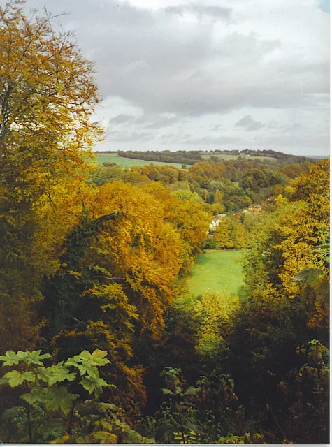
Selborne — village in East Hampshire, England, UK.

Wikimedia Commons contributors — see linked file page for photographer and licence licence
Plan your visit
- Typical visit
- 3 h–6 h
- Nearest railway station
- Alton · 6.4 km
- Free entry
- Family-friendly
- Dog-friendly
About
Selborne is a town, city, village or settlement in the United Kingdom. Recent population estimates put it at around 1,273 people. Wikidata describes it as: "village in East Hampshire, England, UK". Coordinates: 51.0970°, -0.9420°.
Photo gallery
Protected designations
- Site of Special Scientific Interest: Selborne Common SSSI
Designations sourced from Natural England open data under OGL v3.
From the Wikipedia article
Selborne is a village in Hampshire, England, 3.9 miles (6.3 km) south of Alton, and just within the northern boundary of the South Downs National Park. The village receives visitors because of its links with the naturalist Revd. Gilbert White, a pioneer of birdwatching.
Excerpt from Wikipedia under CC BY-SA 4.0. See the source article linked in Sources below.
Background
Description
St Mary the Virgin is a Grade I listed church that dates back to the late 12th century. There is a primary school, and one public house the "Selborne Arms". A bus service that runs through the village links it to Alton and Petersfield. At the back of the village, behind the Selborne Arms and Gilbert White's Field Studies Centre, there is the Zig-Zag Path, which was cut into the hillside in the 1760s by Gilbert White and his brother John, to provide easier access to the Hanger and Selborne Common on the summit of Selborne Hill. A complete history of Selborne, from its geology through its establishment as a settlement in the Dark Ages to the present day, including a study of local…
Sourced from Wikipedia under CC BY-SA 4.0.
- Coordinates
- 51.0970, -0.9420
- County
- Hampshire
- District
- East Hampshire
- Parish
- Selborne
- Postcode
- GU34 3JW
- Parliamentary constituency
- East Hampshire
- Population
- 1,273
- Nearest railway station
- Alton — 6.4 km
- Official site
- www.neighbourhood.statistics.gov.uk
Sources
- wikidata: Q748117 (CC0)
- wikipedia: Selborne (CC BY-SA 4.0)
- commons: Gilbert White's House rear view.jpg (CC BY-SA 4.0)
Other places nearby
Loading nearby places…
Nearby
 📷 5
📷 5Historic houses · South East England
Plestor House
Plestor House — house in Selborne, Hampshire, England, UK.
 📷 5
📷 5Historic houses · South East England
The Wakes
The Wakes — Grade I listed building in East Hampshire, England, UK.
 📷 5
📷 5Museums · South East England
Gilbert White's House
Gilbert White's House — a museum in england-south-east, United Kingdom.
 📷 5
📷 5Memorials & monuments · South East England
Selborne War Memorial
Selborne War Memorial — a memorial in england-south-east, United Kingdom.
 📷 5
📷 5Mountains & hills · South East England
Selborne Hill
Selborne Hill — Named summit at 210 m.
 📷 5
📷 5Mountains & hills · South East England
Noar Hill
Noar Hill — Named summit at 210 m.
More towns in this region
 Flagship📷 10
Towns & cities · South East England
Aldermaston
Aldermaston — village and civil parish in West Berkshire in England, UK.
 Flagship📷 10
Towns & cities · South East England
Aldingbourne
Aldingbourne — village and civil parish in Arun, West Sussex, UK.
 Flagship📷 10
Towns & cities · South East England
Aldington
Aldington — village and civil parish in the Ashford District of Kent, England.
 Flagship📷 10
Towns & cities · South East England
Aldworth
Aldworth — village and civil parish in the English county of Berkshire.
Frequently asked questions
- Where is Selborne?
- Selborne is in Hampshire, South-East England, United Kingdom (postcode GU34 3JW), in the parish of Selborne.
- Is Selborne a protected site?
- Yes — Selborne is part of the Selborne Common SSSI Site of Special Scientific Interest.
- Is Selborne free to visit?
- Yes, Selborne is free to enter.
- How do I get to Selborne?
- The nearest railway station is Alton, about 6.4 km away. Drivers can navigate to postcode GU34 3JW.