Reservoirs & lochs · North East England
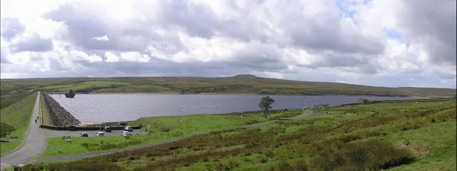
Scaling Dam Reservoir
Scaling Dam Reservoir — reservoir in North Yorkshire, England, UK.

Wikimedia Commons licence
Plan your visit
- Typical visit
- 1 h–2.5 h
- Nearest railway station
- Lealholm · 5.1 km
- Free entry
- Dog-friendly
About
Scaling Dam Reservoir is a reservoir in the United Kingdom. Wikidata describes it as: "reservoir in North Yorkshire, England, UK". Coordinates: 54.5038°, -0.8508°.
Photo gallery
Protected designations
- Site of Special Scientific Interest: North York Moors SSSI
Designations sourced from Natural England open data under OGL v3.
From the Wikipedia article
Scaling Dam Reservoir is a freshwater man-made lake on the edge of the A171 road in North Yorkshire, England. The reservoir is near to the hamlet of Scaling from where it derives its name, and was built in 1958. The reservoir lies inside the North York Moors National Park and the western half is in the Borough of Redcar and Cleveland, whilst the eastern half is in the Borough of Scarborough.
Excerpt from Wikipedia under CC BY-SA 4.0. See the source article linked in Sources below.
Background
History
Scaling Dam Reservoir was built between 1952 and 1958 at a cost of £450,000 and is the largest lake in the North York Moors. The area that the reservoir is built in was named Scaling Dam long before the reservoir was built in 1958; mapping and records show a hamlet of Scaling Dam in the early nineteenth century, and the name is mentioned in Camden's 17th century "Britannia". The dam was constructed by the Tees Valley and Cleveland Water Company and despite being in North Yorkshire (though its on the border between Redcar and Cleveland and the Borough of Scarborough), the dam is owned and regulated by Northumbrian Water. However, fresh water from the dam was historically supplied to…
Sourced from Wikipedia under CC BY-SA 4.0.
- Coordinates
- 54.5038, -0.8508
- District
- Redcar and Cleveland
- Parish
- Loftus
- Postcode
- TS13 4TP
- Parliamentary constituency
- Middlesbrough South and East Cleveland
- Nearest railway station
- Lealholm — 5.1 km
- Official site
- web.archive.org
Sources
- wikidata: Q66712879 (CC0)
- wikipedia: Scaling Dam Reservoir (CC BY-SA 4.0)
Other places nearby
Loading nearby places…
Nearby
Hotels · North East England
Grinkle Park Hotel
Grinkle Park Hotel — a hotel in england north east.
 📷 3
📷 3Archaeological sites · Yorkshire & the Humber
Nean Howe
Nean Howe — a archaeological in england-yorkshire, United Kingdom.
Campsites · Yorkshire & the Humber
Folly Hall Farm Campsite
Folly Hall Farm Campsite — a campsite in england yorkshire.
Viewpoints · Yorkshire & the Humber
Danby Beacon
Danby Beacon is a viewpoint in the United Kingdom.
 📷 3
📷 3Abbeys & priories · North East England
Handale Abbey
Handale Abbey — a abbey in england-north-east, United Kingdom.
 📷 3
📷 3Towns & cities · North East England
Roxby
Roxby — village and civil parish in North Yorkshire, UK.
More places in this region
 Flagship📷 3
Reservoirs & lochs · North East England
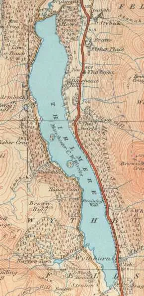
Thirlmere
Thirlmere — reservoir in the United Kingdom.
 📷 2
📷 2Reservoirs & lochs · North East England
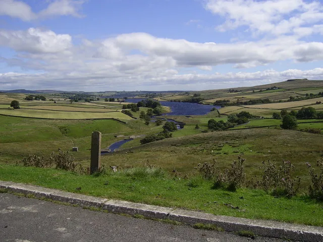
Balderhead Reservoir
Balderhead Reservoir — reservoir in County Durham, England, UK.
 📷 3
📷 3Reservoirs & lochs · North East England
Blackton Reservoir
Blackton Reservoir — reservoir in County Durham, England, UK.
 📷 5
📷 5Reservoirs & lochs · North East England
Cogra Moss
Cogra Moss — reservoir in Cumbria, England, UK.
Frequently asked questions
- Where is Scaling Dam Reservoir?
- Scaling Dam Reservoir is in North-East England, United Kingdom (postcode TS13 4TP), in the parish of Loftus.
- Is Scaling Dam Reservoir a protected site?
- Yes — Scaling Dam Reservoir is part of the North York Moors SSSI Site of Special Scientific Interest.
- How do I get to Scaling Dam Reservoir?
- The nearest railway station is Lealholm, about 5.1 km away. Drivers can navigate to postcode TS13 4TP.