Mountains & hills · South East England
Sandwich Bay
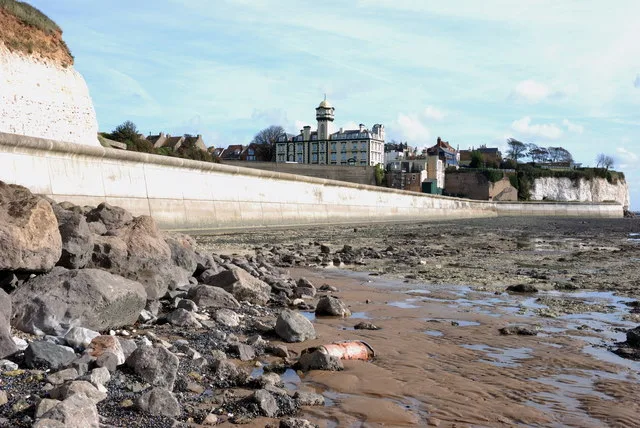
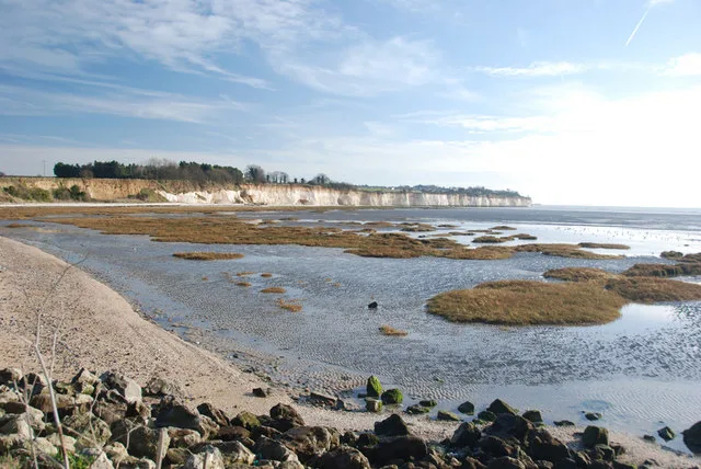
Sandwich Bay — long sweeping inlet of the sea between Ramsgate and Deal, on the east coast of Kent, England.

Wikimedia Commons contributors — see linked file page for photographer and licence licence
Plan your visit
- Typical visit
- 3 h–8 h
- Best time of year
- Late spring – early autumn (May–Oct)
- Nearest railway station
- Thanet Parkway · 3.0 km
- Free entry
- Dog-friendly
About
Sandwich Bay is a named summit in the United Kingdom. Part of North Sea. Wikidata describes it as: "long sweeping inlet of the sea between Ramsgate and Deal, on the east coast of Kent, England". Coordinates: 51.3057°, 1.3759°.
Photo gallery
Protected designations
- Site of Special Scientific Interest: Sandwich Bay to Hacklinge Marshes SSSI
- National Nature Reserve: SANDWICH & PEGWELL BAY
- Area of Outstanding Natural Beauty: Kent Downs
- Ramsar wetland: Thanet Coast & Sandwich Bay
Designations sourced from Natural England open data under OGL v3.
From the Wikipedia article
Sandwich Bay is a long sweeping inlet of the sea between Ramsgate and Deal, on the east coast of Kent, England. The coastal area consists of sand flats with their associated salt marshes and coastal sand dunes. The Sandwich Flats stretch for about five miles (8 km) along the coast. The coastal habitats are of high ecological importance. Most of the bay bears national and international nature conservation designations. These include the Sandwich Bay to Hacklinge Marshes Site of Special Scientific Interest (SSSI), the Sandwich Bay Special Area of Conservation (SAC), the Thanet Coast and Sandwich Bay Special Protection Area for birds (SPA), and the Thanet Coast and Sandwich Bay Ramsar Site. The southern emerald damselfly (Lestes barbarus) was found here in 2003, only the second site in Great Britain at which this vagrant species had occurred. There are several Geological Conservation Review sites within the SSSI. The bay is also home to the Sandwich Bay Bird Observatory Trust and the Monk's Wall nature reserve. The sand dunes at the top of the beach give way to the private road leading through Sandwich Bay estate. There is a 24-hour toll on this road for non-resident motorists of £10.00 per car or £5.00 per motorcycle (2024) but cyclists and pedestrians pass for free. Charges apply 24 hours a day and you buy a ticket at the toll house, or online via the Sandwich Bay website when the toll house is closed. The bay closes to visitors half an hour after sun set and re-opens half an hour before sunrise. However, night fishing is allowed if a ticket is bought in advance. Security patrol the estate and seafront 24 hours a day. The road itself runs along on the top of a concealed sea wall separating the beach from the golf courses which back onto it. Via the toll road the beach is only 3–5 minutes from the historic Cinque port town of Sandwich. There are also scenic footpaths leading from the quay in Sandwich, along the river and over the golf course on the dunes to the bay,…
Excerpt from Wikipedia under CC BY-SA 4.0. See the source article linked in Sources below.
- Coordinates
- 51.3057, 1.3759
- County
- Kent
- District
- Dover
- Parish
- Sandwich
- Postcode
- CT13 9QL
- Parliamentary constituency
- Herne Bay and Sandwich
- Nearest railway station
- Thanet Parkway — 3 km
Sources
- wikidata: Q3370771 (CC0)
- wikipedia: Sandwich Bay, Kent (CC BY-SA 4.0)
- commons: Low tide at Sandwich Bay, looking south - geograph.org.uk - 1002126.jpg (CC BY-SA 4.0)
Other places nearby
Loading nearby places…
Nearby
 📷 5
📷 5Mountains & hills · South East England
Pegwell Bay
Pegwell Bay — bay on the coast of Kent, UK.
 📷 5
📷 5Forests & woodlands · South East England
Sandwich & Pegwell Bay NNR
Sandwich & Pegwell Bay NNR is a forest or woodland in the United Kingdom.
 📷 5
📷 5Natural landmarks · South East England
Pegwell Bay Seal Colony
Pegwell Bay Seal Colony — a other in england-south-east, United Kingdom.
 📷 5
📷 5Golf courses · South East England
Prince's Golf Club, Sandwich
Prince's Golf Club, Sandwich is a golf course in the United Kingdom.
 📷 5
📷 5Archaeological sites · South East England
Caesar's Invasion Site
Caesar's Invasion Site — a archaeological in england-south-east, United Kingdom.
 📷 5
📷 5Wildlife reserves · South East England
Sandwich and Pegwell Bay
Sandwich and Pegwell Bay — nature reserve in Kent, England.
More mountains in this region
 📷 5
📷 5Mountains & hills · South East England
Alum Bay
Alum Bay is a mountain or hill in the United Kingdom.
 📷 5
📷 5Mountains & hills · South East England
Arish Mell
Arish Mell — bay in Dorset, England.
 📷 5
📷 5Mountains & hills · South East England
Balaclava Bay
Balaclava Bay — bay in Dorset, England.
 📷 5
📷 5Mountains & hills · South East England
Balch Cave
Balch Cave — Cave in Somerset, England.
Frequently asked questions
- Where is Sandwich Bay?
- Sandwich Bay is in Kent, South-East England, United Kingdom (postcode CT13 9QL), in the parish of Sandwich.
- Is Sandwich Bay a protected site?
- Yes — Sandwich Bay is part of the Sandwich Bay to Hacklinge Marshes SSSI Site of Special Scientific Interest and the SANDWICH & PEGWELL BAY National Nature Reserve.
- Is Sandwich Bay free to visit?
- Yes, Sandwich Bay is free to enter.
- How do I get to Sandwich Bay?
- The nearest railway station is Thanet Parkway, about 3.0 km away. Drivers can navigate to postcode CT13 9QL.