Memorials & monuments · North East England
Ryhope
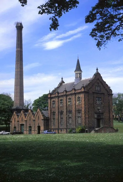
Ryhope in England North East, United Kingdom.

Alex McGregor — CC BY-SA 2.0 via Wikimedia Commons licence
Plan your visit
- Typical visit
- 15 min–45 min
- Free entry
- Dog-friendly
About
Ryhope is a place of interest in England North East, United Kingdom — drawn from open-data sources for visitor reference. See the linked Wikipedia article for the full description.
Photo gallery
From the Wikipedia article
Ryhope ( RY-əp) is a coastal village along the southern boundary of the City of Sunderland, in Tyne and Wear, England. With a population of approximately 14,000, measured at 10.484 in the 2011 census, Ryhope is 2.9 miles to the centre of Sunderland, 2.8 miles to the centre of Seaham, and 1.2 miles from the main A19. The older village section is centred on a triangular 'green', which contains a war monument. The newer 'Colliery' area of Ryhope flanks the Ryhope Street/Tunstall Bank Road, which lead toward the Tunstall and Silksworth areas of Sunderland.
Excerpt from Wikipedia under CC BY-SA 4.0. See the source article linked in Sources below.
Background
History
Ryhope (from the Old English reof hoppas, meaning "rough valley") is first mentioned in 930 AD when king Athelstan granted the land of Bishopwearmouth (including the township of Ryhope) to the Bishop of Chester-le-Street. The land had been reclaimed from the Vikings who had captured it in 918 AD. Ryhope has a strong history of farming; in 1183 there were 22 recorded villeins who provided the landowner with cattle and crops. In 1380 the population had swelled to approximately 150. In 1860 common grazing land was split into plots, which radiated out in strips from the village green. Ryhope's proximity to the sea has allowed it to serve as a seaside destination for centuries. The beach is said…
Visiting
Ryhope Engines Museum, which is based on the Ryhope Pumping Station, was built in 1868 to supply water to the Sunderland area. Among natural features, Ryhope adjoins Tunstall Hills which have views of the city of Sunderland and beyond (on a clear day, down the coast almost to Whitby). The Tunstall Hills are located on the southern outskirts of Sunderland between (New) Silksworth and Ryhope. The disused quarries and cuttings at Tunstall Hills provide exposure through part of the Magnesian Limestone succession of Permian age. The slopes on the "Maiden Paps" section support species such as blue moor-grass, common rock-rose, perennial flax and locally uncommon plants such as Frog Orchid, Autumn…
Sourced from Wikipedia under CC BY-SA 4.0.
- Coordinates
- 54.8679, -1.3698
- District
- Sunderland
- Parish
- Sunderland, unparished area
- Postcode
- SR2 0HT
- Parliamentary constituency
- Sunderland Central
- Official site
- ryhopeengines.org.uk
Sources
Other places nearby
Loading nearby places…
Nearby
 📷 3
📷 3Other places · North East England
Sunderland Ryhope Community Association F.C.
Sunderland Ryhope Community Association F.C. in England North East, United Kingdom.
 📷 5
📷 5Museums · Scottish Lowlands
Ryhope Engines Museum
Ryhope Engines Museum — museum in Sunderland, UK.
 📷 3
📷 3Historic churches · North East England
Venerable Bede Church of England Academy
Venerable Bede Church of England Academy in England North East, United Kingdom.
📷 3Memorials & monuments · Scottish Lowlands
Ryhope Rent Office
Ryhope Rent Office — a memorial in scotland-lowlands, United Kingdom.
 📷 3
📷 3Memorials & monuments · Scottish Lowlands
Ryhope War Memorial
Ryhope War Memorial is a memorial in the United Kingdom.
 📷 3
📷 3Memorials & monuments · Scottish Lowlands
War Memorial at West End
War Memorial at West End — Grade II listed building-listed memorial in scotland-lowlands, United Kingdom.
More memorials in this region
 ★ Iconic📷 3
Memorials & monuments · North East England
Angel of the North
Antony Gormley's 20 m weathered-steel angel above a former colliery.
 📷 3
📷 3Memorials & monuments · North East England
Eston Beacon
Eston Beacon is a memorial in the United Kingdom.
 📷 3
📷 3Memorials & monuments · North East England
Five Lamps
Five Lamps is a memorial in the United Kingdom.
 📷 3
📷 3Memorials & monuments · North East England
Gainford War Memorial
Gainford War Memorial is a memorial in the United Kingdom.
Frequently asked questions
- Where is Ryhope?
- Ryhope is in North-East England, United Kingdom (postcode SR2 0HT), in the parish of Sunderland, unparished area.
- Is Ryhope free to visit?
- Yes, Ryhope is free to enter.
- How do I get to Ryhope?
- Drivers can navigate to postcode SR2 0HT. It sits within the Sunderland Central parliamentary constituency.