Towns & cities · West Midlands
Rostherne
Rostherne — village and former civil parish in Cheshire East, England, UK.

Wikimedia Commons contributors — see linked file page for photographer and licence licence
Plan your visit
- Typical visit
- 3 h–6 h
- Nearest railway station
- Ashley · 2.9 km
- Free entry
- Family-friendly
- Dog-friendly
About
Rostherne is a town, city, village or settlement in the United Kingdom. Recent population estimates put it at around 145 people. Address: WA16. Wikidata describes it as: "village and former civil parish in Cheshire East, England, UK". Coordinates: 53.3500°, -2.3833°.
Photo gallery
Protected designations
- Site of Special Scientific Interest: Rostherne Mere SSSI
- National Nature Reserve: ROSTHERNE MERE
- Ramsar wetland: Rostherne Mere
Designations sourced from Natural England open data under OGL v3.
From the Wikipedia article
Rostherne is a village and former civil parish, now in the parish of Millington and Rostherne, in the unitary authority area of Cheshire East and the ceremonial county of Cheshire, England (grid reference SJ743835). In 2001 the parish had a population of 160. To the north of the village is Rostherne Mere and to the south is Tatton Park. The A556 road passes to its west.
Excerpt from Wikipedia under CC BY-SA 4.0. See the source article linked in Sources below.
Background
History
In the 11th century Rostherene was called Rodestorne, said to mean the Lake of the Holy Cross, from the Anglo-Saxon Rodes, meaning cross and the northern word torne or tarne meaning lake. At the time of the Domesday Book the parish belonged to Gilbert de Venables, Baron of Kinderton, who displaced Ulviet the Saxon as owner of the lands, although there was then only one rateable field in the parish, one team and two acres of wood, the whole only being worth four shillings a year. By 1286 almost all of Rostherne had become part of the Tatton estate, having been sold to Massey of Tatton, except for a portion retained by the Leghs. On 1 April 2023 the parish was abolished to form "Millington…
Architecture
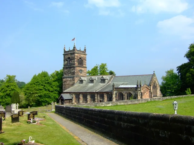
St Mary's Church, Rostherne, is a Grade I listed building, whose rectory was for many centuries in the possession of the Leighs of West Hall, High Legh.
Sourced from Wikipedia under CC BY-SA 4.0.
- Coordinates
- 53.3500, -2.3833
- District
- Cheshire East
- Parish
- Millington and Rostherne
- Postcode
- WA16
- Parliamentary constituency
- Tatton
- Population
- 145
- Nearest railway station
- Ashley — 2.9 km
Sources
- wikidata: Q545862 (CC0)
- wikipedia: Rostherne (CC BY-SA 4.0)
- commons: Rostherne - Saint Mary's Church.jpg (CC BY-SA 4.0)
Other places nearby
Loading nearby places…
Nearby
 📷 3
📷 3Historic churches · West Midlands
St Mary's Church, Rostherne
St Mary's Church, Rostherne — church in Rostherne, Cheshire, England, UK.
 📷 3
📷 3Farms (open to visitors) · West Midlands
Tatton Dale Farm
Tatton Dale Farm — a other in england-west-midlands, United Kingdom.
 📷 4
📷 4Public art & sculpture · West Midlands
Fork
Fork — a public art in england-west-midlands, United Kingdom.
 📷 3
📷 3Memorials & monuments · West Midlands
Airborne Forces Memorial
Airborne Forces Memorial is a memorial in the United Kingdom.
 📷 4
📷 4Historic houses · North West England
Tatton Park
Tatton Park is a historic estate in Cheshire, England, north of the town of Knutsford. It contains a mansion, Tatton Hall; a medieval manor house, Tatton Old Hall; Tatton Park Gardens, a farm and a de
📷 4Gardens · North West England
Tatton Park Flower Show
RHS Flower Show Tatton Park held at Tatton Park, near Knutsford, Cheshire, first began in 1999 by the Royal Horticultural Society. The show houses the RHS National Flower Bed Competition, Young Design
More towns in this region
 Flagship📷 3
Towns & cities · West Midlands
Adderbury
Adderbury — village and civil parish in Cherwell district, Oxfordshire, England.
 Flagship📷 3
Towns & cities · West Midlands
Admington
Admington — village in Warwickshire, England, UK.
 Flagship📷 3
Towns & cities · West Midlands
Aldington
Aldington — village in Worcestershire, United Kingdom.
 Flagship📷 5
Towns & cities · West Midlands
Anstey
Anstey — large village in Leicestershire, England.
Frequently asked questions
- Where is Rostherne?
- Rostherne is in the West Midlands, United Kingdom (postcode WA16), in the parish of Millington and Rostherne.
- Is Rostherne a protected site?
- Yes — Rostherne is part of the Rostherne Mere SSSI Site of Special Scientific Interest and the ROSTHERNE MERE National Nature Reserve.
- Is Rostherne free to visit?
- Yes, Rostherne is free to enter.
- How do I get to Rostherne?
- The nearest railway station is Ashley, about 2.9 km away. Drivers can navigate to postcode WA16.