Natural landmarks · North West England
Reston Scar
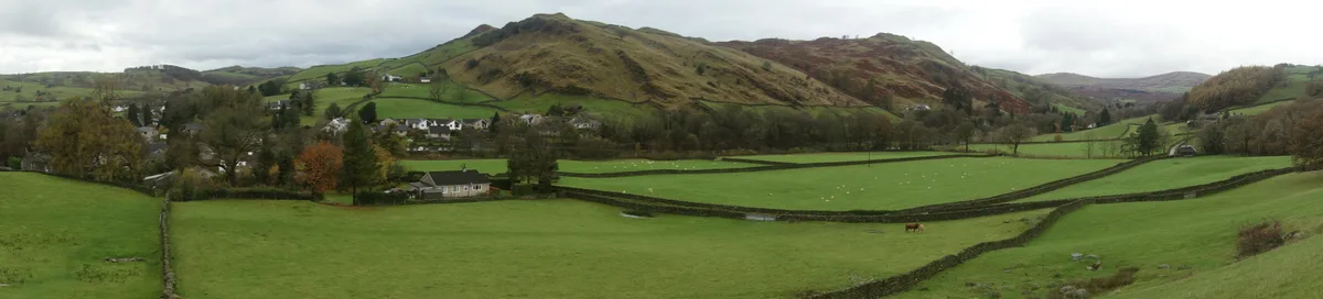
Reston Scar — mountain in United Kingdom.

Wikimedia Commons contributors — see linked file page for photographer and licence licence
Plan your visit
- Typical visit
- 1 h–2 h
- Nearest railway station
- Staveley · 1.1 km
- Free entry
- Dog-friendly
About
Reston Scar is a named natural landmark in the United Kingdom. Wikidata describes it as: "mountain in United Kingdom". Coordinates: 54.3818°, -2.8322°.
Photo gallery
Protected designations
- Site of Special Scientific Interest: River Kent and Tributaries SSSI
- Site of Special Scientific Interest: River Eden and Tributaries SSSI
Designations sourced from Natural England open data under OGL v3.
From the Wikipedia article
Reston Scar is a fell in the Lake District of Cumbria, England. With a height of 837 feet (255 m), it overlooks the north side of Staveley village, and is listed among Alfred Wainwright's The Outlying Fells of Lakeland. The summit offers good views of the Coniston Fells, the Sca Fells and the Langdale Pikes. The main footpath up to the summit from Staveley passes to the south of Kemp Tarn, the largest of several ponds on the Scar. The summit has a cairn. In his book The Outlying Fells of Lakeland, Wainwright describes the ascent of Reston Scar from Staveley and calls the fell "a fine place for a siesta on a sunny day". Wainwright, writing in 1974, says: "From here Hugill Fell and High Knott to the north appear to offer a pleasant extension of the walk, but impassable walls bar the way", but Chris Jesty, in the 2011 2nd edition of Wainwright's book, says "From here Hugill Fell to the north offers a pleasant extension to the walk and an alternative way of returning to Staveley", having mentioned in the section on Hugill Fell that "gates have been provided in the high drystone walls and a clear path links the two summits".
Excerpt from Wikipedia under CC BY-SA 4.0. See the source article linked in Sources below.
- Coordinates
- 54.3818, -2.8322
- District
- Westmorland and Furness
- Parish
- Hugill
- Postcode
- LA8 9PT
- Parliamentary constituency
- Westmorland and Lonsdale
- Nearest railway station
- Staveley — 1.1 km
Sources
- wikidata: Q7316183 (CC0)
- wikipedia: Reston Scar (CC BY-SA 4.0)
- commons: Reston Scar above Staveley from across the valley.JPG (CC BY-SA 4.0)
Other places nearby
Loading nearby places…
Nearby
 📷 4
📷 4Mountains & hills · North West England
Reston Scar
Reston Scar — Named summit at 255 m.
 📷 3
📷 3Historic bridges · North West England
Barley Bridge Over The River Kent
Barley Bridge Over The River Kent — Grade II listed building-listed bridge in england-north-west, United Kingdom.
 📷 5
📷 5Towns & cities · North West England
Staveley
Staveley — village in Cumbria, UK.
 📷 3
📷 3Theatres · North West England
Staveley Roundhouse Theatre
Staveley Roundhouse Theatre is a theatre in the United Kingdom.
Campsites · North West England
Ings Kippers
Ings Kippers — a campsite in england north west.
 📷 3
📷 3Natural landmarks · North West England
Lakeland Farm Visitor Centre
Lakeland Farm Visitor Centre — a natural landmark in england-north-west, United Kingdom.
More natural landmarks in this region
 ★ Iconic📷 4
Natural landmarks · North West England
Coniston Water
Lake District lake — Swallows and Amazons setting and Donald Campbell water-speed history.
 📷 3
📷 3Natural landmarks · North West England
Elter Water
Elter Water — lake in the United Kingdom.
 📷 3
📷 3Natural landmarks · North West England
Esthwaite Water
Esthwaite Water — lake in the United Kingdom.
 Flagship📷 5
Natural landmarks · North West England
Semerwater
Semerwater — lake in North Yorkshire, England, UK.
Frequently asked questions
- Where is Reston Scar?
- Reston Scar is in North-West England, United Kingdom (postcode LA8 9PT), in the parish of Hugill.
- Is Reston Scar a protected site?
- Yes — Reston Scar is part of the River Kent and Tributaries SSSI Site of Special Scientific Interest and the River Eden and Tributaries SSSI Site of Special Scientific Interest.
- Is Reston Scar free to visit?
- Yes, Reston Scar is free to enter.
- How do I get to Reston Scar?
- The nearest railway station is Staveley, about 1.1 km away. Drivers can navigate to postcode LA8 9PT.