Towns & cities · North West England
Quernmore
Quernmore — village and civil parish in Lancashire, UK.

Wikimedia Commons contributors — see linked file page for photographer and licence licence
Plan your visit
- Typical visit
- 3 h–6 h
- Nearest railway station
- Lancaster · 5.5 km
- Free entry
- Family-friendly
- Dog-friendly
About
Quernmore is a town, city, village or settlement in the United Kingdom. Recent population estimates put it at around 532 people. Wikidata describes it as: "village and civil parish in Lancashire, UK". Coordinates: 54.0250°, -2.7340°.
Photo gallery
Protected designations
- Area of Outstanding Natural Beauty: Forest Of Bowland
Designations sourced from Natural England open data under OGL v3.
From the Wikipedia article
Quernmore (pronounced KWOR-mər) is a village and civil parish in the City of Lancaster in Lancashire, England. It is located about 3 miles (5 km) east of Lancaster. The parish of Quernmore had a population of 532 recorded in the 2001 census, increasing to 567 at the 2011 Census. Apart from Quernmore itself, the parish also includes Brow Top, once a local crafts mecca, now barn conversions. The village consists of a small number of residential properties, mostly farm houses, nestling in the bottom of the small valley of the River Conder. The valley has an ancient history. In 1970 a Roman pottery kiln was unearthed near the Friends Meeting House, and other kilns have been discovered in the local vicinity. In former times, the slopes of Clougha Pike which forms the eastern wall of the valley, were mined for millstone grit to form quern stones. There was some small scale coal mining and charcoal production. The valley also has two surviving watermills, one on the slopes towards Littledale and one at Conder Mill whose mill pond now is used as a fishery. Quernmore was at one stage a Royal Forest. The Methodist chapel lies at the heart of the community but is smaller than St Peter's, the Church of England church which lies isolated next to Quernmore Primary School. There used to be one public house whose address is still the Temperance Hotel. The name used to be the Dog and Partridge (this name can still be seen on the electrical substation, 100 yards; metres to the south). It became the Temperance Hotel after the construction of the Thirlmere Aqueduct, completed 1894, as a consequence of the rowdiness of the navvies working on the aqueduct. The public house closed in 1900. The premises became the post office and village store until closure in 2008. The largest residential property is Quernmore Park, built in 1795 by the architect Thomas Harrison. Quernmore lies within the Forest of Bowland Area of Outstanding Natural Beauty, although it is outside the historical area of…
Excerpt from Wikipedia under CC BY-SA 4.0. See the source article linked in Sources below.
- Coordinates
- 54.0250, -2.7340
- County
- Lancashire
- District
- Lancaster
- Parish
- Quernmore
- Postcode
- LA2 9EH
- Parliamentary constituency
- Morecambe and Lunesdale
- Population
- 532
- Nearest railway station
- Lancaster — 5.5 km
Sources
- wikidata: Q988214 (CC0)
- wikipedia: Quernmore (CC BY-SA 4.0)
- commons: Rooten Brook Farm - geograph.org.uk - 1355820.jpg (CC BY-SA 4.0)
Other places nearby
Loading nearby places…
Nearby
 📷 3
📷 3Historic bridges · North West England
Conder Mill Bridge
Conder Mill Bridge is a historic bridge in the United Kingdom.
 📷 3
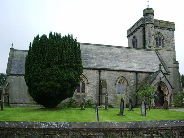
📷 3Historic churches · North West England
St Peter's Church, Quernmore
St Peter's Church, Quernmore — grade II listed church in Quernmore, Lancaster, Lancashire, England, UK.
 📷 3
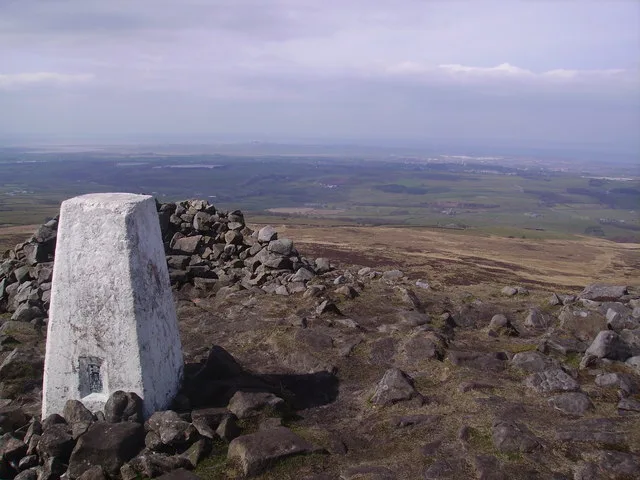
📷 3Natural landmarks · North West England
Clougha Pike
Clougha Pike — mountain in the United Kingdom.
 📷 3
📷 3Mountains & hills · North West England
Clougha Pike
Clougha Pike — Named summit at 410 m.
 📷 4
📷 4Memorials & monuments · North West England
Darren Jones
Darren Jones — a memorial in england-north-west, United Kingdom.
📷 3Memorials & monuments · North West England
Jim Slinn
Jim Slinn — a memorial in england-north-west, United Kingdom.
More towns in this region
 Flagship📷 5
Towns & cities · North West England
Aughton
Aughton — village and civil parish within the West Lancashire district of Lancashire, England.
 Flagship📷 5
Towns & cities · North West England
Haigh
Haigh — village and civil parish of the Metropolitan Borough of Wigan in Greater Manchester, England.
 Flagship📷 5
Towns & cities · North West England
Lancaster
Lancaster — county town of Lancashire, England.
 Flagship📷 3
Towns & cities · North West England
Preston
Preston — city and the administrative centre of Lancashire, England.
Frequently asked questions
- Where is Quernmore?
- Quernmore is in Lancashire, North-West England, United Kingdom (postcode LA2 9EH), in the parish of Quernmore.
- Is Quernmore a protected site?
- Yes — Quernmore is part of the Forest Of Bowland National Landscape (AONB).
- Is Quernmore free to visit?
- Yes, Quernmore is free to enter.
- How do I get to Quernmore?
- The nearest railway station is Lancaster, about 5.5 km away. Drivers can navigate to postcode LA2 9EH.