Beaches · Mid Wales
Poppit Sands
Poppit Sands is a beach in the United Kingdom.

Wikimedia Commons contributors — see linked file page for photographer and licence licence
Plan your visit
- Typical visit
- 1 h–3 h
- Best time of year
- Summer (Jun–Aug)
- Free entry
- Family-friendly
- Dog-friendly
About
Poppit Sands is a named beach on the United Kingdom coastline. Coordinates: 52.1058°, -4.6998°. This entry is part of The Great Britain Guide, a free, ad-free, open-data tourist directory.
Photo gallery
From the Wikipedia article
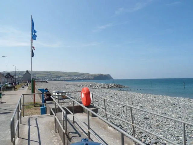
Poppit is a small, dispersed settlement which lies on the southern side of the estuary of the River Teifi, near Cardigan, in northern Pembrokeshire, Wales. It is primarily known for its popular sandy beach, called Poppit Sands (Welsh: Traeth Poppit) which adjoins St Dogmaels beach at its eastern estuary end. The beach offers views across the estuary and bay towards Gwbert and Cardigan Island, and the nearest village is St Dogmaels, 1+1⁄2 miles away. The beach has Blue Flag status and lifeboat and lifeguard cover.
Excerpt from Wikipedia under CC BY-SA 4.0. See the source article linked in Sources below.
Background
Description
Backed by low dunes, the top of the beach comprises about 80m of dry, very loose sand, making it very popular with families. Lower down it is hard-packed. The beach slopes gently, and therefore the sea is shallow for quite a long way out. Even at high tide there is plenty of soft sand exposed. On the eastern side of the dunes, erosion has formed sand cliffs over 4 metres (13 feet) high. New dunes are now building up close to the access boardwalk. When the tide is fully out, the flats at the far south-eastern end (known as Cardigan Bar) extend for nearly a mile and almost reach Gwbert on the other side. However, due to the estuary there are unpredictable currents at this end of the beach. At…
Sourced from Wikipedia under CC BY-SA 4.0.
- Coordinates
- 52.1058, -4.6998
- District
- Pembrokeshire
- Parish
- St. Dogmaels
- Postcode
- SA43 3LR
- Parliamentary constituency
- Ceredigion Preseli
Sources
- wikidata: Q107356895 (CC0)
- commons: Poppit Sands - geograph.org.uk - 4779102.jpg (CC BY-SA 4.0)
- wikipedia: Poppit Sands (CC BY-SA 4.0)
Other places nearby
Loading nearby places…
Nearby
 📷 3
📷 3Beaches · Mid Wales
Cardigan Lifeboat Station
Cardigan Lifeboat Station in Wales Mid, United Kingdom.
 📷 3
📷 3Beaches · Mid Wales
Cei-bâch / Little Quay
Cei-bâch / Little Quay is a beach in the United Kingdom.
Caravan parks · Mid Wales
Cardigan Bay Holiday Park
Cardigan Bay Holiday Park — a caravan park in wales mid.
Hostels · Mid Wales
YHA Poppit Sands
YHA Poppit Sands — a hostel in wales mid.
 📷 3
📷 3Archaeological sites · Mid Wales
Castell Manian Fawr
Castell Manian Fawr — a archaeological in wales-mid, United Kingdom.
 📷 3
📷 3Piers · Mid Wales
Patch Pontoon
Patch Pontoon is a pier in the United Kingdom.
More beaches in this region
.jpg?width=1200) 📷 3
📷 3Beaches · Mid Wales
Aberdovey Bar
Aberdovey Bar is a beach in the United Kingdom.
 📷 3
📷 3Beaches · Mid Wales
Aberfforest Beach
Aberfforest Beach — Beach (pebblestone).
 📷 3
📷 3Beaches · Mid Wales
Bilis
Bilis is a beach in the United Kingdom.
 📷 3
📷 3Beaches · Mid Wales
Borth Beach
Borth Beach is a beach in the United Kingdom.
Frequently asked questions
- Where is Poppit Sands?
- Poppit Sands is in Mid Wales, United Kingdom (postcode SA43 3LR), in the parish of St. Dogmaels.
- Is Poppit Sands free to visit?
- Yes, Poppit Sands is free to enter.
- How do I get to Poppit Sands?
- Drivers can navigate to postcode SA43 3LR. It sits within the Ceredigion Preseli parliamentary constituency.