Mountains & hills · North Wales
Pen Llithrig y Wrach
Also known as: Pen Llithrig-y-wrâch
Pen Llithrig y Wrach — Named summit at 799 m.

Wikimedia Commons contributors — see linked file page for photographer and licence licence
Plan your visit
- Typical visit
- 3 h–8 h
- Best time of year
- Late spring – early autumn (May–Oct)
- Nearest railway station
- Gogledd Llanrwst / North Llanrwst · 7.9 km
- Free entry
- Dog-friendly
About
Pen Llithrig y Wrach is a named summit in the United Kingdom. Also known as: Pen Llithrig-y-wrâch. Wikidata describes it as: "Named summit at 799 m.". Coordinates: 53.1423°, -3.9208°.
Photo gallery
From the Wikipedia article
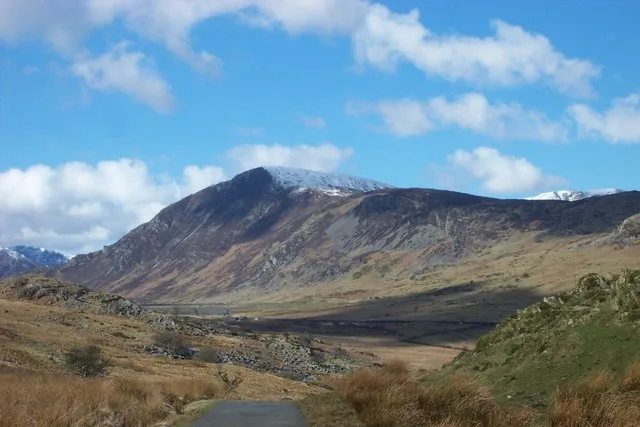
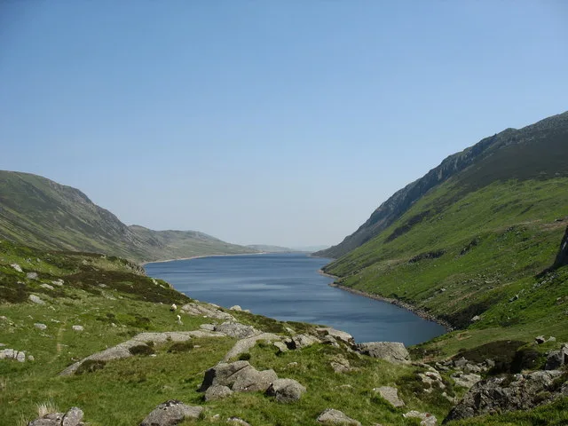
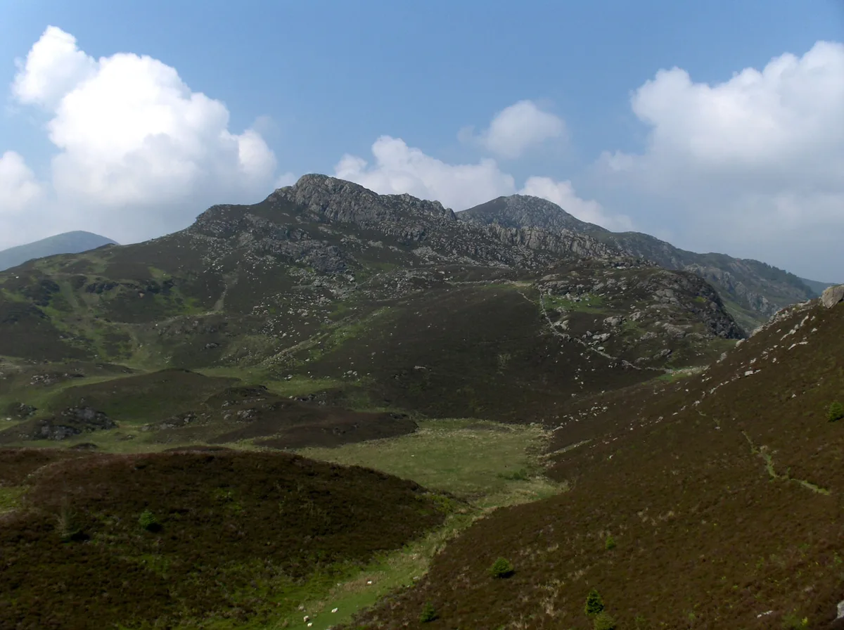
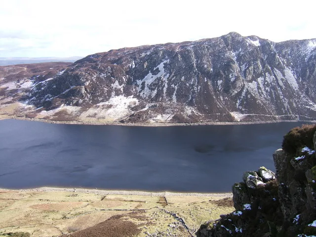
Pen Llithrig y Wrach ('Slippery Head/Top of the Witch') is a mountain peak in Snowdonia, North Wales. It is one of the four Marilyns that make up the Carneddau range. To the east is Creigiau Gleision, another Marilyn, while to the west are Pen yr Helgi Du and Carnedd Llewelyn. Craig Eigiau and Llyn Eigiau can be seen to the north, while Gallt yr Ogof, Glyder Fach and Tryfan can be viewed to the south. It has one of the more colourful names of any British mountain, translating as slippery peak of the witch, perhaps in reference to the boggy conditions underfoot, or because of the resemblance of its pointed profile to an archetypal witch's hat. It is an outlier of the Carneddau, the higher peaks of which can be reached from Pen Llithrig y Wrach via Pen yr Helgi Du. On its eastern side, the mountain slopes steeply down to Llyn Cowlyd. It may be climbed from the southern side, from Capel Curig or the A5, or from the north-east, from Dolgarrog or Tal-y-bont in the Conwy valley. It is quite prominent when viewed from the north near Llandudno.
Excerpt from Wikipedia under CC BY-SA 4.0. See the source article linked in Sources below.
- Coordinates
- 53.1423, -3.9208
- Address
- Conwy, Wales
- Nearest railway station
- Gogledd Llanrwst / North Llanrwst — 7.9 km
Sources
- osm: n340243624 (ODbL)
- wikipedia: Pen Llithrig y Wrach (CC BY-SA 4.0)
- commons: Pen Llithrig y Wrach - geograph.org.uk - 223653.jpg (CC BY-SA 4.0)
Other places nearby
Loading nearby places…
Nearby
 📷 3
📷 3Natural landmarks · North Wales
Pen Llithrig y Wrach
Pen Llithrig y Wrach — mountain (798.6m) in Conwy County Borough.
 📷 3
📷 3Mountains & hills · North Wales
Clogwyn Llech Lefn
Clogwyn Llech Lefn — a mountain in wales-north, United Kingdom, 637 m.
 📷 3
📷 3Reservoirs & lochs · North Wales
Llyn Cowlyd
Llyn Cowlyd — reservoir in the United Kingdom.
 📷 3
📷 3Natural landmarks · North Wales
Creigiau Gleision
Creigiau Gleision — mountain (678m) in Conwy County Borough.
 📷 3
📷 3Mountains & hills · North Wales
Creigau Gleision
Creigau Gleision — Named summit at 678 m.
 📷 3
📷 3Natural landmarks · North Wales
Creigiau Gleision North Top
Creigiau Gleision North Top — mountain (631.8m) in Conwy County Borough.
More mountains in this region
 📷 5
📷 5Mountains & hills · North Wales
Cemlyn Bay and lagoon
Cemlyn Bay and lagoon — Site of Special Scientific Interest in Wales.
 📷 3
📷 3Mountains & hills · North Wales
Aberffraw Bay
Aberffraw Bay — bay on the west coast of Anglesey, in Wales, UK.
 📷 3
📷 3Mountains & hills · North Wales
Allt-fawr
Allt-fawr — Named summit at 698 m.
 📷 3
📷 3Mountains & hills · North Wales
Aran Benllyn
Aran Benllyn — Named summit at 884 m.
Frequently asked questions
- Where is Pen Llithrig y Wrach?
- Pen Llithrig y Wrach is in North Wales, United Kingdom.
- Is Pen Llithrig y Wrach free to visit?
- Yes, Pen Llithrig y Wrach is free to enter.
- How do I get to Pen Llithrig y Wrach?
- The nearest railway station is Gogledd Llanrwst / North Llanrwst, about 7.9 km away.