Mountains & hills · North Wales
Moel Oernant
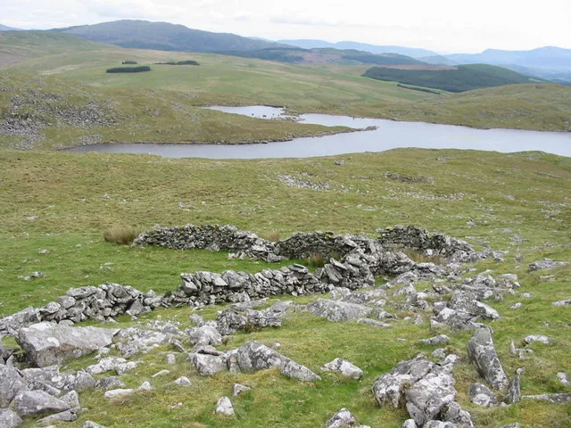
Moel Oernant — Named summit at 503 m.

Wikimedia Commons contributors — see linked file page for photographer and licence licence
Plan your visit
- Typical visit
- 3 h–8 h
- Best time of year
- Late spring – early autumn (May–Oct)
- Free entry
- Dog-friendly
About
Moel Oernant is a named summit in the United Kingdom. Wikidata describes it as: "Named summit at 503 m.". Coordinates: 52.8895°, -3.8696°.
Photo gallery
From the Wikipedia article
Moel Oernant is a 503-metre (1,650 ft) high hill in the community of Trawsfynydd in the county of Gwynedd in North Wales. It has a number of western tops, the highest of which reaches a height of 466 metres (1,529 ft) overlooking the waterbody known as Llyn Gelli-Gain and another at Frîdd Wen exceeds 410 metres (1,350 ft). To the south of the lake is the top of Pîg Idris which reaches 429m. The minor top of Y-Foel attains 430m to the northeast of Moel Oernant.
Excerpt from Wikipedia under CC BY-SA 4.0. See the source article linked in Sources below.
Background
Visiting
A public bridleway continuing as a public footpath runs from Cwm Prysor southwest across the northern and western flanks of the hill towards Trawsfynydd. Other than parts of its northern slopes the entire hill is mapped as open country under the Countryside and Rights of Way Act 2000 and therefore freely available for public access on foot. Along its southern and eastern margin is a minor public road beside the Afon Gain.
Sourced from Wikipedia under CC BY-SA 4.0.
- Coordinates
- 52.8895, -3.8696
- Address
- Gwynedd, Wales
- Official site
- www.hill-bagging.co.uk
Sources
- osm: n29761910 (ODbL)
- wikipedia: Moel Oernant (CC BY-SA 4.0)
- commons: Farmland and Moel Oernant - geograph.org.uk - 157781.jpg (CC BY-SA 4.0)
Other places nearby
Loading nearby places…
Nearby
 📷 3
📷 3Mountains & hills · North Wales
Craiglaseithin
Craiglaseithin — a mountain in wales-north, United Kingdom, 466 m.
 📷 3
📷 3Reservoirs & lochs · North Wales
Llyn Gelligain
Llyn Gelligain — lake in Gwynedd, Wales.
 Flagship📷 5
National parks · North Wales
Eryri (Snowdonia)
Eryri (Snowdonia) is a Mountainous region and national park in North Wales.
 📷 3
📷 3Museums · North Wales
Yr Ysgwrn
Yr Ysgwrn — a museum in wales-north, United Kingdom.
 📷 3
📷 3Archaeological sites · North Wales
Roman Practice Camp
Roman Practice Camp — a archaeological in wales-north, United Kingdom.
 📷 3
📷 3Archaeological sites · North Wales
Bedd Porus
Bedd Porus — a archaeological in wales-north, United Kingdom.
More mountains in this region
 📷 5
📷 5Mountains & hills · North Wales
Cemlyn Bay and lagoon
Cemlyn Bay and lagoon — Site of Special Scientific Interest in Wales.
 📷 3
📷 3Mountains & hills · North Wales
Aberffraw Bay
Aberffraw Bay — bay on the west coast of Anglesey, in Wales, UK.
 📷 3
📷 3Mountains & hills · North Wales
Allt-fawr
Allt-fawr — Named summit at 698 m.
 📷 3
📷 3Mountains & hills · North Wales
Aran Benllyn
Aran Benllyn — Named summit at 884 m.
Frequently asked questions
- Where is Moel Oernant?
- Moel Oernant is in North Wales, in the United Kingdom — coordinates 52.8895°, -3.8696°.
- Is Moel Oernant free to visit?
- Yes — admission to Moel Oernant is free.