Hill forts · South West England
Mên-an-Tol
Also known as: Men an Toll
Mên-an-Tol — standing stones near the Madron–Morvah road in Cornwall, England, UK.

Wikimedia Commons contributors — see linked file page for photographer and licence licence
Plan your visit
- Typical visit
- 1 h–2 h
- Nearest railway station
- Penzance · 6.5 km
- Free entry
- Dog-friendly
About
Mên-an-Tol is a hill fort in the United Kingdom. Heritage designation: scheduled monument. Wikidata describes it as: "standing stones near the Madron–Morvah road in Cornwall, England, UK". Coordinates: 50.1586°, -5.6045°.
Photo gallery
Protected designations
- Site of Special Scientific Interest: Aire Point to Carrick Du SSSI
- Site of Special Scientific Interest: West Penwith Moors and Downs SSSI
- Area of Outstanding Natural Beauty: Cornwall
Designations sourced from Natural England open data under OGL v3.
From the Wikipedia article
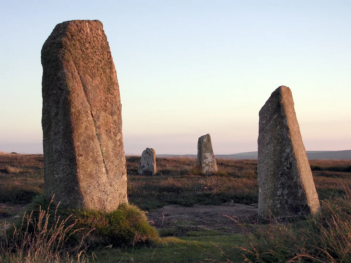
The Mên-an-Tol (Cornish: Men an Toll) is a small formation of standing stones in Cornwall, England (grid reference SW426349). It is about three miles northwest of Madron. It is also known locally as the "Crick Stone".
Excerpt from Wikipedia under CC BY-SA 4.0. See the source article linked in Sources below.
Background
History
In 1749 the site was first archaeologically investigated by William Borlase, who also drew a plan. This shows that the megaliths were not in a line like today, but formed an angle of about 135°. Borlase also reported that farmers had taken away some stones from the area. From him comes the first written record of the myths and rituals. In the 19th Century the local antiquary John Thomas Blight published several drawings of the site, and made the first suggestion that the stones could be the remains of a stone circle. In 1872 William Copeland Borlase, a descendant of the earlier Borlase, gave a more detailed description of the area. In 1932 Hugh O'Neill Hencken wrote the first modern…
Description
The Mên-an-Tol consists of three upright granite stones: a round stone with its middle holed out with two standing stones to each side, in front of and behind the hole. The two side stones are both about 1.2 metres high. The westernmost stone was moved and brought into a straight line with the other two stones sometime after 1815. The holed stone is roughly octagonal in outline. It is 1.3 metres wide and 1.1 metres high; the circular hole is 0.5 m in diameter. The only other holed stone in Cornwall of this type is the Tolvan holed stone which can be seen in a garden near Helston. There is one other standing stone nearby, and six recumbent stones, some of which are buried. A cairn exists as…
Sourced from Wikipedia under CC BY-SA 4.0.
- Coordinates
- 50.1586, -5.6045
- District
- Cornwall
- Parish
- Madron
- Postcode
- TR20 8NX
- Parliamentary constituency
- St Ives
- Nearest railway station
- Penzance — 6.5 km
Sources
- wikidata: Q1899569 (CC0)
- wikipedia: Mên-an-Tol (CC BY-SA 4.0)
- commons: Men-an-Tol 2004.jpg (CC BY-SA 4.0)
Other places nearby
Loading nearby places…
Nearby
 📷 5
📷 5Hill forts · South West England
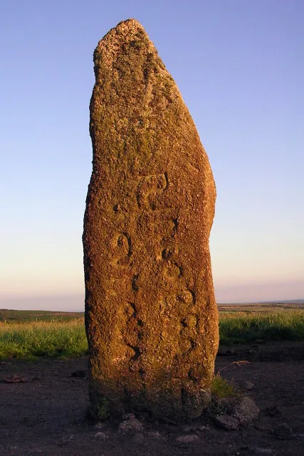
Mên Scryfa
Mên Scryfa — early Christian memorial stone in Madron, Cornwall, England, UK.
 📷 3
📷 3Memorials & monuments · South West England
Four Parishes Rock
Four Parishes Rock — a memorial in england-south-west, United Kingdom.
 📷 5
📷 5Windmills · South West England
Standing stone 60m north west of the Nine Maidens Stone Circle
Standing stone 60m north west of the Nine Maidens Stone Circle — a post mill in england-south-west, United Kingdom.
 📷 5
📷 5Hill forts · South West England
Boskednan stone circle
Boskednan stone circle — stone circle in Cornwall, England, UK.
 📷 3
📷 3Burial mounds & barrows · South West England
Bosiliack Barrow
Bosiliack Barrow — a burial mound in england-south-west, United Kingdom.
 📷 3
📷 3Historic houses · South West England
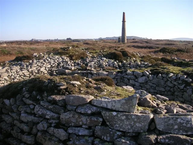
Greenburrow Engine House (Ding Dong Mine)
Greenburrow Engine House (Ding Dong Mine) — a historic house in england-south-west, United Kingdom.
More places in this region
 📷 5
📷 5Hill forts · South West England
Ballowall Barrow
Ballowall Barrow — archaeological site in St Just, Cornwall, England, UK.
 📷 5
📷 5Hill forts · South West England
Barnstaple Castle
Barnstaple Castle — castle in Devon, England, UK.
 📷 5
📷 5Hill forts · South West England
Bartinney Castle
Bartinney Castle — Iron Age enclosure in Cornwall, England, UK.
 📷 5
📷 5Hill forts · South West England
Berry's Wood
Berry's Wood — iron Age hill fort in south Devon, England, UK.
Frequently asked questions
- Where is Mên-an-Tol?
- Mên-an-Tol is in South-West England, United Kingdom (postcode TR20 8NX), in the parish of Madron.
- Is Mên-an-Tol a listed building?
- Mên-an-Tol is officially recognised as scheduled monument listed.
- Is Mên-an-Tol a protected site?
- Yes — Mên-an-Tol is part of the Aire Point to Carrick Du SSSI Site of Special Scientific Interest and the West Penwith Moors and Downs SSSI Site of Special Scientific Interest.
- Is Mên-an-Tol free to visit?
- Yes, Mên-an-Tol is free to enter.
- How do I get to Mên-an-Tol?
- The nearest railway station is Penzance, about 6.5 km away. Drivers can navigate to postcode TR20 8NX.