Mountains & hills · North Wales
Maesglase (Craig Rhiw-erch)
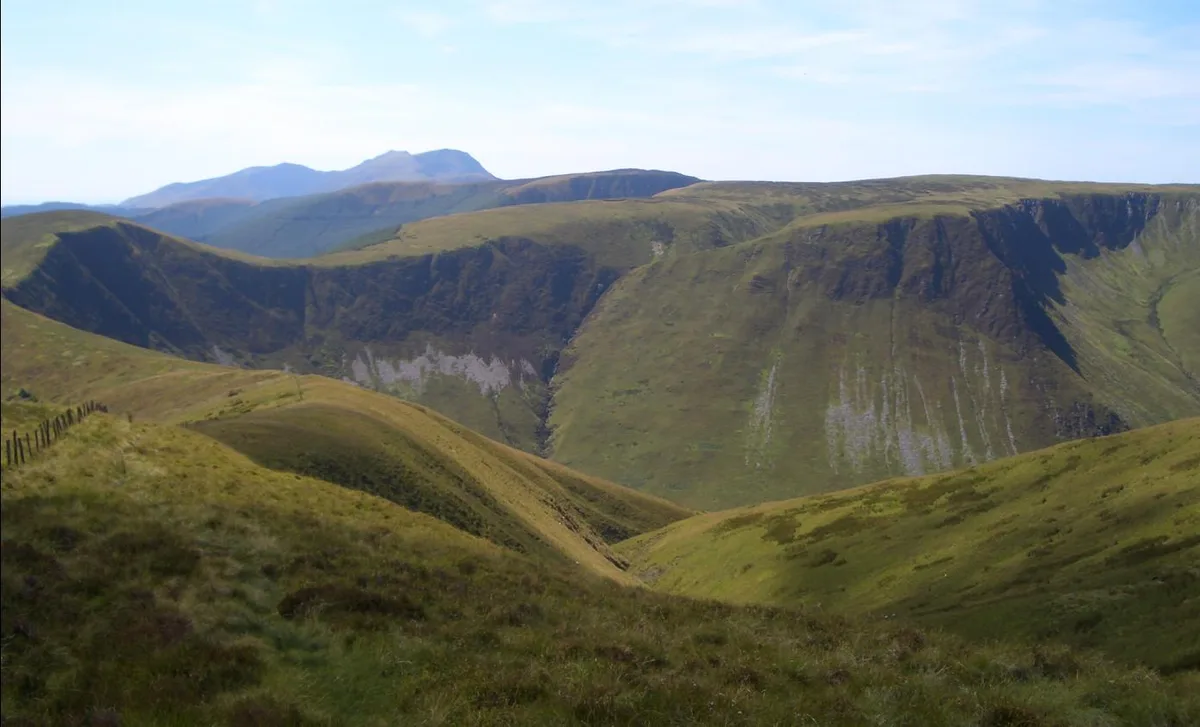
Maesglase (Craig Rhiw-erch) — Named summit at 678 m.

Wikimedia Commons contributors — see linked file page for photographer and licence licence
Plan your visit
- Typical visit
- 3 h–8 h
- Best time of year
- Late spring – early autumn (May–Oct)
- Nearest railway station
- Corris · 9.5 km
- Free entry
- Dog-friendly
About
Maesglase (Craig Rhiw-erch) is a named summit in the United Kingdom. Wikidata describes it as: "Named summit at 678 m.". Coordinates: 52.7200°, -3.7525°.
Photo gallery
From the Wikipedia article
Maesglase is a mountain in Snowdonia, North Wales, situated approximately four miles to the south-west of Aran Fawddwy. It is the highest of the Dyfi Hills. It can be reached by an easy but steep walk through the forestry from Dinas Mawddwy or directly from the bwlch on the A470. Ascending Maesglase provides an opportunity to climb several other nearby peaks including Maen-Du, Craig Rhiw-erch, Waun-oer, Mynydd Dolgoed and Cribin Fawr which are linked by a series of ridges and arêtes. The precise location of the summit is the subject of some confusion. Traditionally, the top of Maen Du (674 metres (2,211 ft) at SH823152) was regarded as Maesglase's summit. However, more recent surveys suggest that the top of Craig Rhiw-erch (c 676 metres (2,218 ft) at SH817150, some 600 metres (2,000 ft) to the west) is higher. A recent survey puts it at 678.5 metres (2,226 ft). The geomorphology of these mountains is classical U-shaped glacial valleys with textbook examples of hanging valleys and intersecting valleys. The eastern slopes are devoted to sheep farming whilst the western slopes are intensively forested. Above the semi-improved grassland is some bracken but much of the higher ground is covered in typical Calluna / Erica communities interspersed with large areas of Juncus, Carex and Sphagnum bogs. The tops of Cribin Fawr are flat expanses of peat-hags. On the eastern flanks Bilberry (Vaccinium myrtillus) grows in abundance with Cowberry (Vaccinium vitis-idaea) common on the highest ground. Half a mile to the west of the peak of Cribin Fawr at a high point of 659 metres (2,162 ft) is a stone boundary marker dated 1861 and inscribed CCC and bearing a benchmark. Maesglase waterfall has a total height of 160 metres (520 ft). To the south lie the parallel ridges leading to Mynydd Dolgoed and Mynydd Gartheiniog. The site is the location of the Welsh-language novel O! Tyn y Gorchudd! by Angharad Price.
Excerpt from Wikipedia under CC BY-SA 4.0. See the source article linked in Sources below.
- Coordinates
- 52.7200, -3.7525
- Address
- Snowdonia, Wales
- Nearest railway station
- Corris — 9.5 km
Sources
- osm: n29747303 (ODbL)
- wikipedia: Maesglase (CC BY-SA 4.0)
- commons: Maesglase.jpg (CC BY-SA 4.0)
Featured in this guide
Other places nearby
Loading nearby places…
Nearby
 📷 3
📷 3Mountains & hills · North Wales
Maen Du
Maen Du — a mountain in wales-north, United Kingdom, 674 m.
 📷 4
📷 4Mountains & hills · North Wales
Craig Portas East Top
Craig Portas East Top — a mountain in wales-north, United Kingdom, 587 m.
 📷 4
📷 4Viewpoints · North Wales
Bluebell Hill
Bluebell Hill is a viewpoint in the United Kingdom.
 📷 3
📷 3Mountains & hills · North Wales
Craig Portas
Craig Portas — a mountain in wales-north, United Kingdom, 604 m.
 📷 3
📷 3Viewpoints · North Wales
Bwlch (Top Ledge / Middle Ledge)
Bwlch (Top Ledge / Middle Ledge) is a viewpoint in the United Kingdom.
 📷 3
📷 3Natural landmarks · North Wales
Cribin Fawr
Cribin Fawr — mountain (658.8m) in Gwynedd.
More mountains in this region
 📷 5
📷 5Mountains & hills · North Wales
Cemlyn Bay and lagoon
Cemlyn Bay and lagoon — Site of Special Scientific Interest in Wales.
 📷 3
📷 3Mountains & hills · North Wales
Aberffraw Bay
Aberffraw Bay — bay on the west coast of Anglesey, in Wales, UK.
 📷 3
📷 3Mountains & hills · North Wales
Allt-fawr
Allt-fawr — Named summit at 698 m.
 📷 3
📷 3Mountains & hills · North Wales
Aran Benllyn
Aran Benllyn — Named summit at 884 m.
Frequently asked questions
- Where is Maesglase (Craig Rhiw-erch)?
- Maesglase (Craig Rhiw-erch) is in North Wales, in the United Kingdom — coordinates 52.7200°, -3.7525°. The nearest railway station is Corris, around 9.5 km away.
- Is Maesglase (Craig Rhiw-erch) free to visit?
- Yes — admission to Maesglase (Craig Rhiw-erch) is free.