Mountains & hills · West Midlands
Lud's Church
Lud's Church — deep chasm on the hillside above Gradbach, Staffordshire, England.

Wikimedia Commons contributors — see linked file page for photographer and licence licence
Plan your visit
- Typical visit
- 3 h–8 h
- Best time of year
- Late spring – early autumn (May–Oct)
- Nearest railway station
- Hunthouse Wood · 7.2 km
- Free entry
- Family-friendly
- Dog-friendly
About
Lud's Church is a named summit in the United Kingdom. Wikidata describes it as: "deep chasm on the hillside above Gradbach, Staffordshire, England". Coordinates: 53.1878°, -2.0206°.
Photo gallery
Protected designations
- Site of Special Scientific Interest: Leek Moors SSSI
Designations sourced from Natural England open data under OGL v3.
From the Wikipedia article
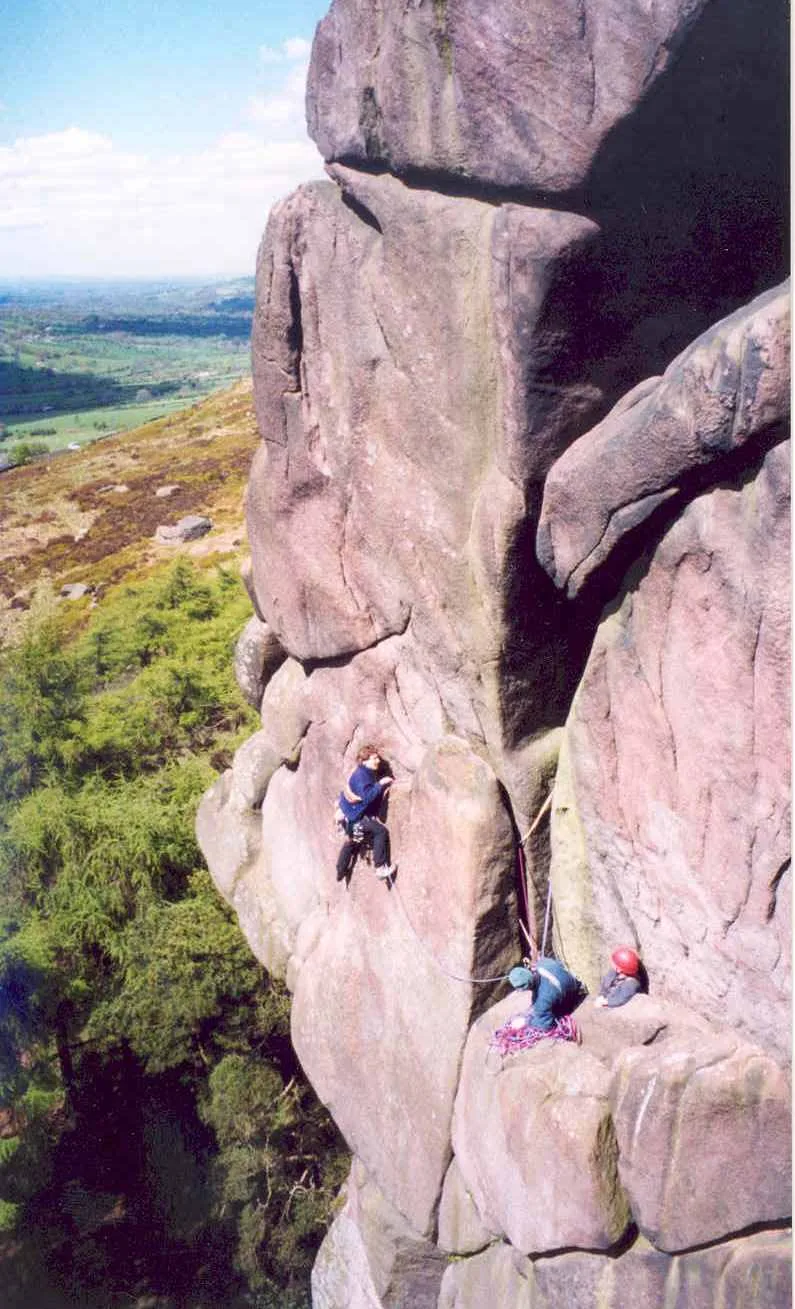
Lud's Church (sometimes written as Ludchurch) is a deep chasm penetrating the Millstone Grit bedrock created by a massive landslip on the hillside above Gradbach, Staffordshire, England. It is located in a wood known as Back Forest, in the Dark Peak, towards the southwest fringe of the Peak District National Park about 2.5 miles (4.0 km) west of the A53 between Leek and Buxton. Over 100 metres (328 ft) long and 18 metres (59 ft) deep, all but the upper third of the slope has slipped forward towards the River Dane. It is mossy and overgrown, wet and cool even on the hottest of days.
Excerpt from Wikipedia under CC BY-SA 4.0. See the source article linked in Sources below.
Background
History
The area has a place in Christian history: the Lollards, who were followers of John Wycliffe, an early church reformer, are supposed to have used this as a secret place of worship during the early 15th century, when they were being persecuted for their religious beliefs. Lud's Church may have been named after Walter de Ludank or Walter de Lud-Auk who was captured here at one of their meetings. A number of climbing routes up the sides of the chasm were pioneered during the 20th century, but climbing is now discouraged to protect the lower plants that have colonised the damp rockfaces.
Sourced from Wikipedia under CC BY-SA 4.0.
- Coordinates
- 53.1878, -2.0206
- District
- Cheshire East
- Parish
- Macclesfield Forest and Wildboarclough
- Postcode
- SK11 0BH
- Parliamentary constituency
- Macclesfield
- Nearest railway station
- Hunthouse Wood — 7.2 km
Sources
- wikidata: Q6698667 (CC0)
- wikipedia: Lud's Church (CC BY-SA 4.0)
- commons: Lud's Church 2016-06-05.jpg (CC BY-SA 4.0)
Other places nearby
Loading nearby places…
Nearby
Climbing & bouldering crags · West Midlands
Back Forest Edge
Back Forest Edge — a climbing crag in england west midlands.
Hostels · West Midlands
The Farmhouse
The Farmhouse — a hostel in england west midlands.
Hostels · West Midlands
The Cottage
The Cottage — a hostel in england west midlands.
Campsites · West Midlands
Gradbach Scout Camp
Gradbach Scout Camp — a campsite in england west midlands.
 📷 3
📷 3Historic houses · West Midlands
Swythamley Hall
Swythamley Hall — house in Heaton, Staffordshire Moorlands, England, UK.
 📷 3
📷 3Mountains & hills · East Midlands
The Roaches
The Roaches — Named summit at 505 m.
More mountains in this region
 📷 5
📷 5Mountains & hills · West Midlands
Arbury Hill
Arbury Hill — Named summit at 224.3 m.
Mountains & hills · West Midlands
Barr Beacon
Barr Beacon — Named summit at 227 m.
 📷 3
📷 3Mountains & hills · West Midlands
Barrow Hill
Barrow Hill — Named summit at 179 m.
Mountains & hills · West Midlands
Beacon Hill
Beacon Hill — Named summit at 237 m.
Frequently asked questions
- Where is Lud's Church?
- Lud's Church is in the West Midlands, United Kingdom (postcode SK11 0BH), in the parish of Macclesfield Forest and Wildboarclough.
- Is Lud's Church a protected site?
- Yes — Lud's Church is part of the Leek Moors SSSI Site of Special Scientific Interest.
- Is Lud's Church free to visit?
- Yes, Lud's Church is free to enter.
- How do I get to Lud's Church?
- The nearest railway station is Hunthouse Wood, about 7.2 km away. Drivers can navigate to postcode SK11 0BH.