Towns & cities · South East England
Ludgershall
Also known as: Ludgershall, Wiltshire
Ludgershall — village and civil parish in Wiltshire, UK.

Wikimedia Commons contributors — see linked file page for photographer and licence licence
Plan your visit
- Typical visit
- 3 h–6 h
- Nearest railway station
- Grateley · 9.6 km
- Free entry
- Family-friendly
- Dog-friendly
About
Ludgershall is a town, city, village or settlement in the United Kingdom. Recent population estimates put it at around 3,775 people. Address: SP11. Wikidata describes it as: "village and civil parish in Wiltshire, UK". Coordinates: 51.2566°, -1.6209°.
Photo gallery
Protected designations
- Area of Outstanding Natural Beauty: North Wessex Downs
Designations sourced from Natural England open data under OGL v3.
From the Wikipedia article
Ludgershall ( LUG-ər-shawl, with a hard g) is a town and civil parish 16 miles (26 km) north east of Salisbury, Wiltshire, England. It is on the A342 road between Devizes and Andover. The parish includes Faberstown which is contiguous with Ludgershall, and the hamlet of Biddesden which lies 2 miles (3.2 km) to the east, on the border with Hampshire.
Excerpt from Wikipedia under CC BY-SA 4.0. See the source article linked in Sources below.
Background
History
There is evidence of settlement in the late Bronze Age or early Iron Age at Windmill Down on the western edge of the parish. The name Ludgershall derives from the Old English lūtegār "a spear set as a trap to impale wild animals" and halh "a nook of land". The Domesday Book of 1086 recorded small settlements at Ludgershall and Biddesden. The entry for Litlegarsele reads: "Edward of Salisbury holds Ludgershall. Alfward held it before 1066; it paid tax for one hide (about 24 acres). Land for 3 ploughs. In Lordship 2 ploughs, 3 slaves; 8 Cottagers with 1 plough. Pasture 3 furlongs long and 1 furlong wide; woodland ½ league long and 2 furlongs wide." The value was 100 shillings. Ludgershall…
Description
Ludgershall has developed considerably in the late 20th and early 21st centuries, and is now an important town supporting a number of flourishing businesses and a considerable amount of housing. Part of the former Army depot site became Castledown Business Park. The community is well provided for in terms of entertainment and shops with two pubs and social clubs, a number of small independent traders, and two supermarket chains. There is a primary school – Ludgershall Castle Primary School, built in 1965 as a secondary school for girls – and a secondary school: The Wellington Academy, opened in 2011. A second primary school, Wellington Eagles, was opened in 2020.
Sourced from Wikipedia under CC BY-SA 4.0.
- Coordinates
- 51.2566, -1.6209
- District
- Wiltshire
- Parish
- Ludgershall
- Postcode
- SP11
- Parliamentary constituency
- East Wiltshire
- Population
- 3,775
- Nearest railway station
- Grateley — 9.6 km
- Official site
- www.ludgershall-tc.gov.uk
Sources
- wikidata: Q643318 (CC0)
- wikipedia: Ludgershall, Wiltshire (CC BY-SA 4.0)
- commons: Ludgershall, The former Prince of Wales Hotel - geograph.org.uk - 1406172.jpg (CC BY-SA 4.0)
Other places nearby
Loading nearby places…
Nearby
 📷 5
📷 5Memorials & monuments · South East England
Ludgershall Cross
Ludgershall Cross is a memorial in the United Kingdom.
 📷 5
📷 5Memorials & monuments · South East England
Ludgershall War Memorial
Ludgershall War Memorial — Grade II listed building-listed memorial in england-south-east, United Kingdom.
 📷 5
📷 5Memorials & monuments · South East England
Unidentified Monument In Churchyard, Approximately 16 Metres South Of South Porch, Church Of St James
Unidentified Monument In Churchyard, Approximately 16 Metres South Of South Porch, Church Of St James — Grade II listed building-listed memorial in england-south-east, United Kingdom.
 📷 5
📷 5Memorials & monuments · South East England
Unidentified Monument In Churchyard, Approximately 13 Metres South Of Tower, Church Of St James
Unidentified Monument In Churchyard, Approximately 13 Metres South Of Tower, Church Of St James — Grade II listed building-listed memorial in england-south-east, United Kingdom.
 📷 5
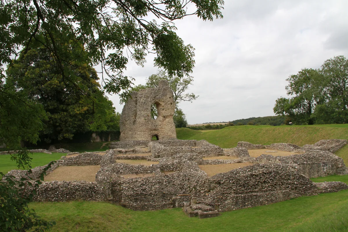
📷 5Castles · South East England
Ludgershall Castle
Ludgershall Castle — castle in Ludgershall, Wiltshire, England, UK.
 📷 5
📷 5Historic houses · South East England
Biddesden House
Biddesden House — Grade I listed house in Chute Forest, Wiltshire, England, UK.
More towns in this region
 Flagship📷 10
Towns & cities · South East England
Aldermaston
Aldermaston — village and civil parish in West Berkshire in England, UK.
 Flagship📷 10
Towns & cities · South East England
Aldingbourne
Aldingbourne — village and civil parish in Arun, West Sussex, UK.
 Flagship📷 10
Towns & cities · South East England
Aldington
Aldington — village and civil parish in the Ashford District of Kent, England.
 Flagship📷 10
Towns & cities · South East England
Aldworth
Aldworth — village and civil parish in the English county of Berkshire.
Frequently asked questions
- Where is Ludgershall?
- Ludgershall is in South-East England, United Kingdom (postcode SP11), in the parish of Ludgershall.
- Is Ludgershall a protected site?
- Yes — Ludgershall is part of the North Wessex Downs National Landscape (AONB).
- Is Ludgershall free to visit?
- Yes, Ludgershall is free to enter.
- How do I get to Ludgershall?
- Drivers can navigate to postcode SP11. It sits within the East Wiltshire parliamentary constituency.