Reservoirs & lochs · Scottish Highlands
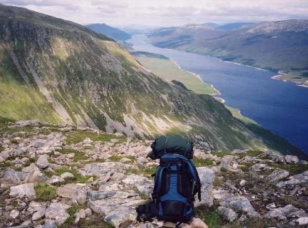
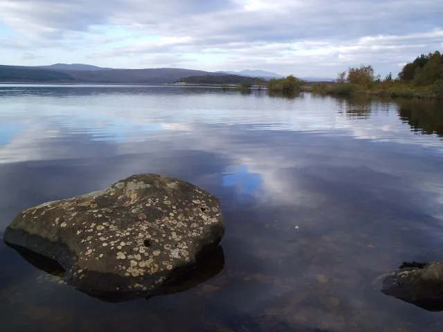
Loch Thom
Loch Thom — reservoir in Inverclyde, Scotland, UK, outflows to the Upper Gryfe reservoir.

Wikimedia Commons contributors — see linked file page for photographer and licence licence
Plan your visit
- Typical visit
- 1 h–2.5 h
- Nearest railway station
- Drumfrochar · 3.4 km
- Free entry
- Dog-friendly
About
Loch Thom is a reservoir in the United Kingdom. Wikidata describes it as: "reservoir in Inverclyde, Scotland, UK, outflows to the Upper Gryfe reservoir". Coordinates: 55.9119°, -4.7854°.
Photo gallery
From the Wikipedia article
Loch Thom is a reservoir which since 1827 has provided a water supply to the town of Greenock in Inverclyde, Scotland. It is named after the civil engineer Robert Thom who designed the scheme which created the reservoir and delivered water via a long aqueduct known as The Cut. Today, as well as providing a water supply, the loch is used for sport fishing and forms part of the Clyde Muirshiel Regional Park with several attractive walks and a centre at Cornalees Bridge providing nature study facilities. The loch is about 2.4 km from north to south, curving to the east in a rough C-shape, and is at an elevation of about 195 m above sea level. From the northern arm an outlet feeds southwest a short distance to a compensation reservoir at the centre of the "C", which then connects at Cornalees Bridge to the start of The Cut.
Excerpt from Wikipedia under CC BY-SA 4.0. See the source article linked in Sources below.
Background
History
In the late 18th century Greenock was a rapidly expanding seaport with industries developing as the Industrial Revolution gathered pace. Its location on the north slopes of hills sweeping down to the south bank of the Firth of Clyde meant that several fast flowing streams provided supplies, and a number of wells provided clean water for domestic use. This was supplemented in 1773 by a piped water system designed by James Watt supplying some areas, but there was increasing demand for water powered mills. On the far side of the hills to the south of the town a natural dip held a freshwater lake known as Shaws Water at a level high above the town. The civil engineer Robert Thom from Rothesay…
Description
From Cornalees Bridge The Cut runs west then turns northward following along the contour of Dunrod Hill which it follows round until running eastwards directly above the town of Greenock at Overton, having come a distance of 9 km. On the way it collects some of the water from streams that cross its path, and a series of sluice gates incorporated an ingenious automatic way of releasing surplus water. As shown in the picture of a restored mechanism, when the aqueduct is over full, water flows down the pipe in the foreground and fills the bucket, which then pulls the chain down over the pulley wheel and lifts the counterweight and the lever opening the sluice gate. Small holes in the bucket…
Sourced from Wikipedia under CC BY-SA 4.0.
- Coordinates
- 55.9119, -4.7854
- District
- Inverclyde
- Postcode
- PA16 9LY
- Parliamentary constituency
- Inverclyde and Renfrewshire West
- Nearest railway station
- Drumfrochar — 3.4 km
Sources
- wikidata: Q4267500 (CC0)
- wikipedia: Loch Thom (CC BY-SA 4.0)
- commons: Loch-Thom-snow-270210g.jpg (CC BY-SA 4.0)
Other places nearby
Loading nearby places…
Nearby
 📷 3
📷 3Memorials & monuments · Scottish Highlands
Argyll & Sutherland Highlanders Memorial Well
Argyll & Sutherland Highlanders Memorial Well — a memorial in scotland-highlands, United Kingdom.
 📷 3
📷 3Archaeological sites · Scottish Highlands
Decoy Control Bunker (Gg3)
Decoy Control Bunker (Gg3) — a archaeological in scotland-highlands, United Kingdom.
 📷 3
📷 3Reservoirs & lochs · Scottish Highlands
Gryffe Reservoirs
Gryffe Reservoirs — reservoirs in Inverclyde, Scotland, United Kingdom.
 📷 3
📷 3Reservoirs & lochs · Scottish Highlands
Upper Gryffe Reservoir
Upper Gryffe Reservoir — reservoir in Inverclyde, Scotland, United Kingdom, outflows to the Lower Gryffe Reservoir.
 📷 3
📷 3Reservoirs & lochs · Scottish Highlands
Whinhill Reservoir
Whinhill Reservoir — reservoir in Inverclyde, Scotland, UK.
 📷 3
📷 3Reservoirs & lochs · Scottish Highlands
Lower Gryffe Reservoir
Lower Gryffe Reservoir — reservoir in Inverclyde, Scotland, United Kingdom.
More places in this region
 Flagship📷 3
Reservoirs & lochs · Scottish Highlands
Loch Ericht
Loch Ericht — lake in Perth and Kinross, and Highland, Scotland, UK, outflows to River Ericht.
 Flagship📷 3
Reservoirs & lochs · Scottish Highlands
Loch Shin
Loch Shin — reservoir in Highland, Scotland, UK, outflows to the River Shin.
 📷 3
📷 3Reservoirs & lochs · Scottish Highlands
Allt na Lairige Reservoir
Allt na Lairige Reservoir — 1956 artificial lake in Argyll and Bute, Scotland, UK, on and outflowing west to Allt na Lairige.
.jpg?width=1200) 📷 3
📷 3Reservoirs & lochs · Scottish Highlands
Ardlussa Fishing Loch
Ardlussa Fishing Loch — 1900 artificial lake on Jura, Argyll and Bute, Scotland, UK, on the Lussa River.
Frequently asked questions
- Where is Loch Thom?
- Loch Thom is in Scottish Highlands, in the United Kingdom — coordinates 55.9119°, -4.7854°. The nearest railway station is Drumfrochar, around 3.4 km away.
- Is Loch Thom free to visit?
- Yes — admission to Loch Thom is free.