Natural landmarks · Scottish Lowlands
Ling Fell
Ling Fell — mountain in United Kingdom.

Wikimedia Commons contributors — see linked file page for photographer and licence licence
Plan your visit
- Typical visit
- 1 h–2 h
- Free entry
- Dog-friendly
About
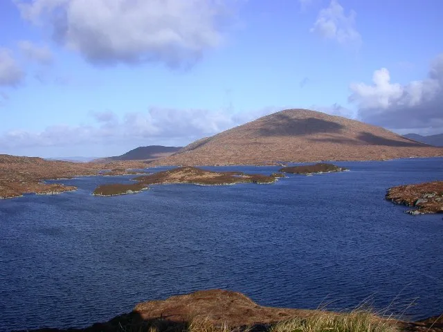
Ling Fell is a named natural landmark in the United Kingdom. Wikidata describes it as: "mountain in United Kingdom". Coordinates: 54.6450°, -3.2740°.
Photo gallery
Protected designations
- Site of Special Scientific Interest: River Derwent and Tributaries SSSI
Designations sourced from Natural England open data under OGL v3.
From the Wikipedia article
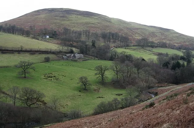
Ling Fell is a small hill in the north west of the Lake District in the United Kingdom. It is close to the village of Wythop Mill, from where it can easily be climbed. The fell is shaped like a wide dome, with no particular dangers. Its name derives from the fact that it is largely covered in heather, also known as "ling". The summit has good views of the town of Cockermouth.
Excerpt from Wikipedia under CC BY-SA 4.0. See the source article linked in Sources below.
- Coordinates
- 54.6450, -3.2740
- District
- Cumberland
- Parish
- Embleton
- Postcode
- CA13 9YS
- Parliamentary constituency
- Penrith and Solway
Sources
- wikidata: Q6553690 (CC0)
- wikipedia: Ling Fell (CC BY-SA 4.0)
- commons: Ling Fell.jpg (CC BY-SA 4.0)
Other places nearby
Loading nearby places…
Nearby
 📷 3
📷 3Mountains & hills · Scottish Lowlands
Ling Fell
Ling Fell — Named summit at 374 m.
 📷 3
📷 3Mountains & hills · Scottish Lowlands
Sale Fell
Sale Fell — Named summit at 359 m.
 📷 3
📷 3Natural landmarks · Scottish Lowlands
Graystones
Graystones — mountain in United Kingdom.
 📷 3
📷 3Natural landmarks · Scottish Lowlands
Sale Fell
Sale Fell — mountain in United Kingdom.
 📷 3
📷 3Mountains & hills · Scottish Lowlands
Graystones
Graystones — Named summit at 455.3 m.
 📷 3
📷 3Towns & cities · Scottish Lowlands
Embleton
Embleton — village and civil parish in Cumbria, England, UK.
More natural landmarks in this region
 Flagship📷 3
Natural landmarks · Scottish Lowlands
Bassenthwaite Lake
Bassenthwaite Lake — lake in Cumbria, England, UK.
 Flagship📷 3
Natural landmarks · Scottish Lowlands
Loch Enoch
Loch Enoch — lake in Dumfries and Galloway, Scotland, UK.
 📷 5
📷 5Natural landmarks · Scottish Lowlands
Annandale Water
Annandale Water — lake in Dumfries and Galloway, Scotland, UK.
 📷 3
📷 3Natural landmarks · Scottish Lowlands
Bakestall
Bakestall — mountain in United Kingdom.
Frequently asked questions
- Where is Ling Fell?
- Ling Fell is in the Scottish Lowlands, United Kingdom (postcode CA13 9YS), in the parish of Embleton.
- Is Ling Fell a protected site?
- Yes — Ling Fell is part of the River Derwent and Tributaries SSSI Site of Special Scientific Interest.
- Is Ling Fell free to visit?
- Yes, Ling Fell is free to enter.
- How do I get to Ling Fell?
- Drivers can navigate to postcode CA13 9YS. It sits within the Penrith and Solway parliamentary constituency.