Towns & cities · Northern Ireland
Killinchy
Also known as: Cill Dhuinsí
Killinchy — village in County Down, Northern Ireland.

Wikimedia Commons contributors — see linked file page for photographer and licence licence
Plan your visit
- Typical visit
- 3 h–6 h
- Nearest railway station
- Delamont · 9.4 km
- Free entry
- Family-friendly
- Dog-friendly
About
Killinchy is a town, city, village or settlement in the United Kingdom. Wikidata describes it as: "village in County Down, Northern Ireland". Coordinates: 54.4667°, -5.6667°.
Photo gallery
From the Wikipedia article
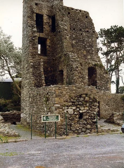
Killinchy (from Irish Cill Dhuinsí, meaning 'Duinseach’s church') is a townland and small village in County Down, Northern Ireland. It is two miles inland from the western shores of Strangford Lough in the Borough of Ards and North Down. It is situated in the townland of the same name, the civil parish of Killinchy and the historic barony of Dufferin. It had a population of 539 people (205 households) in the 2011 Census. (2001 Census: 492 people) The village sits on a hill overlooking Strangford Lough. The nearby settlement of Balloo is treated as part of Killinchy. Sketrick Castle is located near Killinchy and is estimated to date back to the 15th century. The Annals of the Four Masters record the capture of the castle in 1470. It was intact until the end of the 19th century when a storm demolished much of it. In 1957 a stone subterranean passage was discovered. Killinchy has a community hall and a playground. Killinchy has three churches: Killinchy Presbyterian Church, Killinchy Non-Subscribing Presbyterian Church and Killinchy Church of Ireland. In 1978 a new church hall, car park and playing fields were built, on the opposite side of the road to the Presbyterian church, to complement the Anderson Memorial Hall (built 1898). The Moore Graveyard sits at the top of the car park.
Excerpt from Wikipedia under CC BY-SA 4.0. See the source article linked in Sources below.
- Coordinates
- 54.4667, -5.6667
- District
- Ards and North Down
- Postcode
- BT23 6TN
- Parliamentary constituency
- Strangford
- Nearest railway station
- Delamont — 9.4 km
Sources
- wikidata: Q205095 (CC0)
- wikipedia: Killinchy (CC BY-SA 4.0)
- commons: Church, Killinchy - geograph.org.uk - 281850.jpg (CC BY-SA 4.0)
Other places nearby
Loading nearby places…
Nearby
 📷 3
📷 3Natural landmarks · Northern Ireland
Balloo
Balloo in Northern Ireland, United Kingdom.
 📷 5
📷 5Natural landmarks · Northern Ireland
Whiterock
Whiterock in Northern Ireland, United Kingdom.
Campsites · Northern Ireland
The Lodge at Quarterland Bay Camp Site
The Lodge at Quarterland Bay Camp Site — a campsite in northern ireland.
 📷 2
📷 2Natural landmarks · Northern Ireland
Ringhaddy
Ringhaddy in Northern Ireland, United Kingdom.
 📷 3
📷 3Castles · Northern Ireland
Sketrick Castle
Sketrick Castle — castle in Killinchy, County Down, Northern Ireland.
 📷 3
📷 3Castles · Northern Ireland
Sketrick Castle (ruin)
Sketrick Castle (ruin) — a castle in northern-ireland, United Kingdom.
More towns in this region
 Flagship📷 5
Towns & cities · Northern Ireland
Bangor
Bangor — city in Northern Ireland, United Kingdom.
 Flagship📷 5
Towns & cities · Northern Ireland
Belfast
Belfast — capital city of Northern Ireland.
 Flagship📷 3
Towns & cities · Northern Ireland
Derry
Derry — city in Northern Ireland.
 Flagship📷 5
Towns & cities · Northern Ireland
Lisburn
Lisburn — city in Northern Ireland.
Frequently asked questions
- Where is Killinchy?
- Killinchy is in Northern Ireland, United Kingdom (postcode BT23 6TN).
- Is Killinchy free to visit?
- Yes, Killinchy is free to enter.
- How do I get to Killinchy?
- Drivers can navigate to postcode BT23 6TN. It sits within the Strangford parliamentary constituency.