Towns & cities · East Midlands
Keyworth
Keyworth — village in Nottinghamshire, England.

Wikimedia Commons licence
Plan your visit
- Typical visit
- 3 h–6 h
- Nearest railway station
- Park Gate · 4.4 km
- Free entry
- Family-friendly
- Dog-friendly
About
Keyworth is a town, city, village or settlement in the United Kingdom. Recent population estimates put it at around 6,733 people. Address: NG12. Wikidata describes it as: "village in Nottinghamshire, England". Coordinates: 52.8739°, -1.0831°.
Photo gallery
From the Wikipedia article
Keyworth () is a village and civil parish of Nottinghamshire, England. It is located about 6 miles (10 km) southeast of the centre of Nottingham. It sits on a small, broad hilltop about 200 feet above sea level which is set in the wider undulating boulder clay that characterises the area south of Nottingham. The village logo is a local windmill which was demolished in the 1950s. The former site of the windmill was on Selby Lane. Keyworth is twinned with the French town of Feignies.
Excerpt from Wikipedia under CC BY-SA 4.0. See the source article linked in Sources below.
Background
History
Keyworth is first mentioned in writing in the Domesday Book dated 1086, though recent archaeological finds have discovered Roman artefacts in the parish outskirts suggesting human inhabitation of the area as far back as 800 AD. Keyworth originally developed as an agricultural community with the great majority of its inhabitants being farmers and field labourers. Later, frame-knitting gave rise to local employment and expansion in the 1880s. Listed buildings in the village includes two grade II barns dating from the 17th century, one late 18th century house built in the Regency style, two early 19th century cottages on Main Street, and two grade II Former framework knitters' workshops. In…
Sourced from Wikipedia under CC BY-SA 4.0.
- Coordinates
- 52.8739, -1.0831
- County
- Nottinghamshire
- District
- Rushcliffe
- Parish
- Keyworth
- Postcode
- NG12
- Parliamentary constituency
- Rushcliffe
- Population
- 6,733
- Nearest railway station
- Park Gate — 4.4 km
- Official site
- www.keyworthparishcouncil.org
Sources
Other places nearby
Loading nearby places…
Nearby
 📷 3
📷 3Memorials & monuments · East Midlands
The Rectory Field
The Rectory Field — a memorial in england-east-midlands, United Kingdom.
 📷 3
📷 3Historic churches · East Midlands
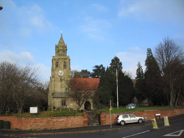
Church of St Mary Magdalene, Keyworth
Church of St Mary Magdalene, Keyworth — Grade I listed church in Keyworth, Rushcliffe, Nottinghamshire, England, UK.
 📷 4
📷 4Memorials & monuments · East Midlands
Martyn's Barn
Martyn's Barn — a memorial in england-east-midlands, United Kingdom.
 📷 3
📷 3Historic churches · East Midlands
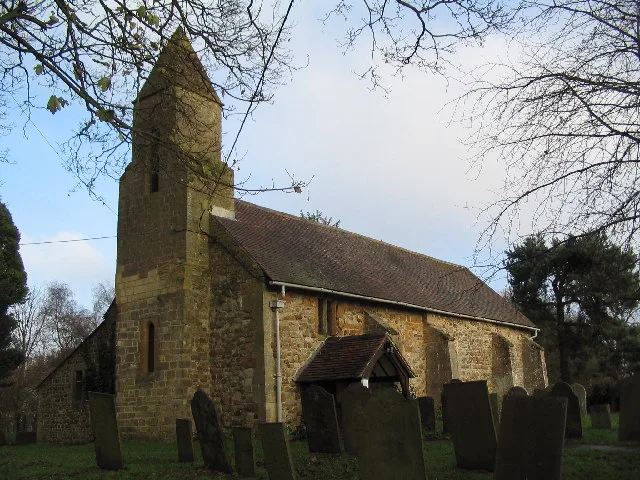
All Saints' Church, Stanton on the Wolds
All Saints' Church, Stanton on the Wolds — grade II listed church in Stanton-on-the-Wolds, Rushcliffe, Nottinghamshire, England, UK.
 📷 3
📷 3Memorials & monuments · East Midlands
Stanton-on-the-Wolds War Memorial
Stanton-on-the-Wolds War Memorial — Grade II listed building-listed memorial in england-east-midlands, United Kingdom.
 📷 3
📷 3Historic houses · East Midlands
Normanton House
Normanton House — house in Normanton on the Wolds, Rushcliffe, Nottinghamshire, England, UK.
More towns in this region
 Flagship📷 3
Towns & cities · East Midlands
Aldborough
Aldborough — village in Norfolk, England, UK.
 Flagship📷 4
Towns & cities · East Midlands
Alderford
Alderford — village and civil parish in Norfolk, UK.
 Flagship📷 5
Towns & cities · East Midlands
Ashmanhaugh
Ashmanhaugh — village in Norfolk, England, UK.
 Flagship📷 3
Towns & cities · East Midlands
Attlebridge
Attlebridge — a village located in Broadland, United Kingdom.
Frequently asked questions
- Where is Keyworth?
- Keyworth is in Nottinghamshire, the East Midlands, United Kingdom (postcode NG12), in the parish of Keyworth.
- Is Keyworth free to visit?
- Yes, Keyworth is free to enter.
- How do I get to Keyworth?
- The nearest railway station is Park Gate, about 4.4 km away. Drivers can navigate to postcode NG12.