Mountains & hills · East Midlands
High Wheeldon
High Wheeldon — Named summit at 422 m.

Wikimedia Commons contributors — see linked file page for photographer and licence licence
Plan your visit
- Typical visit
- 3 h–8 h
- Best time of year
- Late spring – early autumn (May–Oct)
- Nearest railway station
- Buxton Miniature Railway · 8.5 km
- Free entry
- Dog-friendly
About
High Wheeldon is a named summit in the United Kingdom. Wikidata describes it as: "Named summit at 422 m.". Coordinates: 53.1920°, -1.8512°.
Photo gallery
From the Wikipedia article
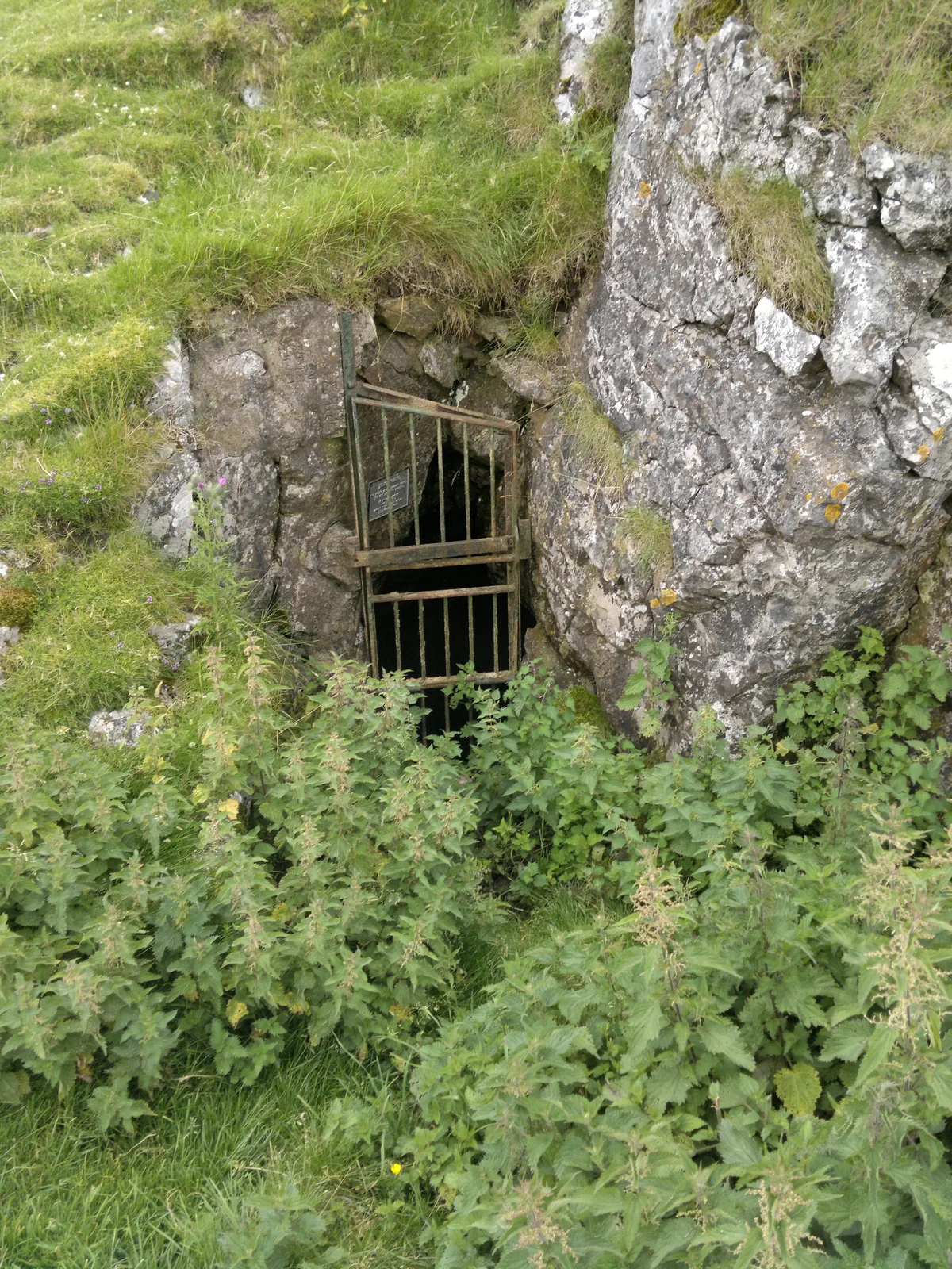
High Wheeldon is a dome-shaped hill near the Staffordshire border in Hartington Middle Quarter civil parish, Derbyshire, in the Peak District valley of Upper Dovedale, overlooking the villages of Earl Sterndale, Longnor and Crowdecote. It is close to Chrome Hill and Parkhouse Hill. High Wheeldon has been in the care of the National Trust since 1946 when it was donated by the owner to the Trust as a war memorial. A plaque at the summit says that the hill was presented 'in honoured memory of the men of Derbyshire and Staffordshire who fell in the Second World War'. Slightly below the summit of the hill is a rock shelter called Fox Hole Cave, which is closed by an iron gate as it has archaeological significance. Items, including Peterborough ware, early Bronze Age pottery, a stone axe, flint microliths and animal bones, have been found in the cave, which is believed to have been used from the Upper Paleolithic. The cave is a scheduled monument.
Excerpt from Wikipedia under CC BY-SA 4.0. See the source article linked in Sources below.
- Coordinates
- 53.1920, -1.8512
- County
- Derbyshire
- District
- Derbyshire Dales
- Parish
- Hartington Middle Quarter
- Postcode
- SK17 0DA
- Parliamentary constituency
- Derbyshire Dales
- Nearest railway station
- Buxton Miniature Railway — 8.5 km
Sources
- osm: n3884540830 (ODbL)
- wikipedia: High Wheeldon (CC BY-SA 4.0)
- commons: High Wheeldon, near Earl Sterndale - geograph.org.uk - 1460927.jpg (CC BY-SA 4.0)
Other places nearby
Loading nearby places…
Nearby
 📷 3
📷 3Mountains & hills · East Midlands
Fox Hole Cave
Fox Hole Cave — cave in Hartington Middle Quarter, Derbyshire, England, UK.
Campsites · East Midlands
Crowdecote Campsite
Crowdecote Campsite — a campsite in england east midlands.
 📷 3
📷 3Historic bridges · East Midlands
Crowdecote Bridge
Crowdecote Bridge — Grade II listed building-listed bridge in england-east-midlands, United Kingdom.
 📷 3
📷 3Burial mounds & barrows · East Midlands
Cronkston Low Bowl Barrow
Cronkston Low Bowl Barrow — a burial mound in england-east-midlands, United Kingdom.
 📷 3
📷 3Historic houses · East Midlands
Coachman's house to rear of Crewe and Harpur Arms
Coachman's house to rear of Crewe and Harpur Arms — Grade II listed house in Longnor, Staffordshire Moorlands, Staffordshire, England, UK.
Caravan parks · East Midlands
Pomeroy Camping and Caravan Park
Pomeroy Camping and Caravan Park — a caravan park in england east midlands.
More mountains in this region
 📷 3
📷 3Mountains & hills · East Midlands
Axe Edge Moor
Axe Edge Moor — Named summit at 551 m.
Mountains & hills · East Midlands
Beacon Hill
Beacon Hill — Named summit at 244.5 m.
Mountains & hills · East Midlands
Beacon Hill
Beacon Hill — Named summit at 105 m.
 📷 3
📷 3Mountains & hills · East Midlands
Black Edge - Summit
Black Edge - Summit — Named summit at 506.7 m.
Frequently asked questions
- Where is High Wheeldon?
- High Wheeldon is in Derbyshire, the East Midlands, United Kingdom (postcode SK17 0DA), in the parish of Hartington Middle Quarter.
- Is High Wheeldon free to visit?
- Yes, High Wheeldon is free to enter.
- How do I get to High Wheeldon?
- Drivers can navigate to postcode SK17 0DA. It sits within the Derbyshire Dales parliamentary constituency.