Towns & cities · South East England
Hever
Hever — village and civil parish in Kent, England.

Wikimedia Commons contributors — see linked file page for photographer and licence licence
Plan your visit
- Typical visit
- 3 h–6 h
- Nearest railway station
- Hever · 1.1 km
- Free entry
- Family-friendly
- Dog-friendly
About
Hever is a town, city, village or settlement in the United Kingdom. Recent population estimates put it at around 1,136 people. Address: TN8. Wikidata describes it as: "village and civil parish in Kent, England". Coordinates: 51.1835°, 0.1105°.
Photo gallery
Protected designations
- Area of Outstanding Natural Beauty: High Weald
- Area of Outstanding Natural Beauty: Kent Downs
Designations sourced from Natural England open data under OGL v3.
From the Wikipedia article
Hever is a village and civil parish in the Sevenoaks District of Kent, England. The parish is located on the River Eden, a tributary of the River Medway, east of Edenbridge. It is 5 miles (8 km) by 1-mile (1.6 km) in extent, and 3,062 acres (12.39 km2) in area. The parish includes the villages of Four Elms, Hever itself, and Markbeech, and had a population of 1,136 in 2001, increasing to 1,231 at the 2011 Census. The place-name 'Hever' may come from 'Heanyfre', meaning 'high edge', which is attested in Saxon charter S175 of 814, referring to an altogether different place. Hever contains Hever Castle, the childhood home of Anne Boleyn, second wife of King Henry VIII. There are three parish churches, one at each village. All are one united benefice. In the parish church of St Peter is the tomb of Thomas Boleyn, the father of Anne Boleyn and grandfather of Queen Elizabeth I. Hever Church of England Primary School is near the centre of the village. Hever railway station is 1.2 miles (1.9 km) west of the village by total road distance. It is on the Oxted line between Uckfield and Oxted, with services often continuing to London Bridge.
Excerpt from Wikipedia under CC BY-SA 4.0. See the source article linked in Sources below.
- Coordinates
- 51.1835, 0.1105
- County
- Kent
- District
- Sevenoaks
- Parish
- Hever
- Postcode
- TN8
- Parliamentary constituency
- Tonbridge
- Population
- 1,136
- Nearest railway station
- Hever — 1.1 km
- Official site
- www.ksymuseum.org.uk
Sources
- wikidata: Q954918 (CC0)
- wikipedia: Hever, Kent (CC BY-SA 4.0)
- commons: Hever Church.JPG (CC BY-SA 4.0)
Other places nearby
Loading nearby places…
Nearby
 📷 5
📷 5Memorials & monuments · South East England
Hever War Memorial
Hever War Memorial — Grade II listed building-listed memorial in england-south-east, United Kingdom.
📷 5Historic churches · South East England
Church of St Peter
Church of St Peter — church in Hever, Kent, England, UK.
 📷 5
📷 5Museums · South East England
Kent and Sharpshooters Yeomanry Museum Kent and Sharpshooters Yeomanry Museum
Kent and Sharpshooters Yeomanry Museum Kent and Sharpshooters Yeomanry Museum — a museum in england-south-east, United Kingdom.
 📷 5
📷 5Castles · South East England
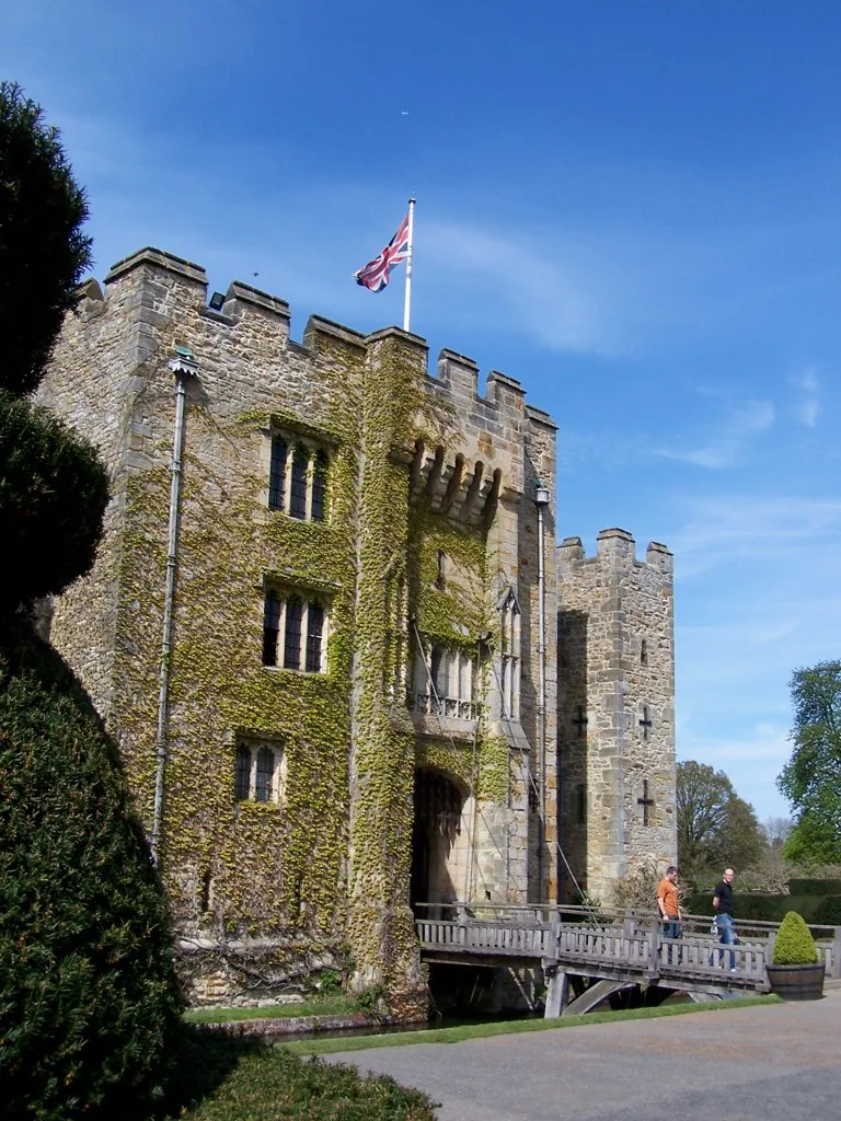
Hever Castle
Hever Castle — Grade I listed country house in Hever, Kent, England, UK.
 📷 5
📷 5Gardens · South East England
Italian Sculpture Garden To South East Of Hever Castle
Italian Sculpture Garden To South East Of Hever Castle — sculptures and garden near Hever Castle, Kent, England, UK.
 📷 5
📷 5Public art & sculpture · South East England
Italian Sculpture Garden To South East Of Hever Castle
Italian Sculpture Garden To South East Of Hever Castle in England South East, United Kingdom.
More towns in this region
 Flagship📷 10
Towns & cities · South East England
Aldermaston
Aldermaston — village and civil parish in West Berkshire in England, UK.
 Flagship📷 10
Towns & cities · South East England
Aldingbourne
Aldingbourne — village and civil parish in Arun, West Sussex, UK.
 Flagship📷 10
Towns & cities · South East England
Aldington
Aldington — village and civil parish in the Ashford District of Kent, England.
 Flagship📷 10
Towns & cities · South East England
Aldworth
Aldworth — village and civil parish in the English county of Berkshire.
Frequently asked questions
- Where is Hever?
- Hever is in Kent, South-East England, United Kingdom (postcode TN8), in the parish of Hever.
- Is Hever a protected site?
- Yes — Hever is part of the High Weald National Landscape (AONB) and the Kent Downs National Landscape (AONB).
- Is Hever free to visit?
- Yes, Hever is free to enter.
- How do I get to Hever?
- The nearest railway station is Hever, about 1.1 km away. Drivers can navigate to postcode TN8.